
|
|
Mountain/Rock |
|---|---|
|
|
46.75600°N / 88.156°W |
|
|
Baraga |
|
|
Hiking |
|
|
Spring, Summer, Fall, Winter |
|
|
1979 ft / 603 m |
|
|
Overview
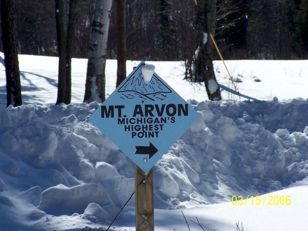
Mt. Arvon is certainly not the most imposing peak on this website, in fact it may contend for the lowest peak included on the list. It is, however, Michigan's highest point and not far from where I live so I thought I'd do it the honor of including it here.
It is located in the Huron Mountain Range in the north-central Upper Peninsula, or U.P, as it is known by locals. The mountain rises over 1300 feet from the shores of Lake Superior 10 miles or so to the north.
Strangely enough Mt. Arvon has only been recognized as the state's highpoint since 1982. Previously the highest point was nearby Mt. Curwood at 1978 ft. When the USGS did a survey that year, however, it found Mt. Arvon to be 1979.238 feet, taller by a mere 11 inches! It is still disputed which is taller and some maps still incorrectly label Curwood as the highest.
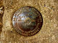
Benchmark
Not long ago Mt. Arvon had the reputation of being one of the most diffucult state highpoints to reach. Not due to a technical climb but due to remoteness and the maze of logging roads in the area. In the past few years however many improvements have been made. The road is now well-graded and numerous blue signs along the way help keep you on the right track on your way up. The road still is steep and rocky in a few sections, mainly within the last 2 miles, but can be driven with care by most vehicles (I wouldn't recommend taking your new Caddie or BMW up it, however!!). Even so, I recommend stopping by the Baraga County Tourist Information building to inquire on road conditions before setting out. Address and phone number info is below.
How To Get There
The following is an excerpt from the Indian Country Sports - Mt. Arvon page. It provides a detailed description on how to reach Mt. Arvon from US-41 in L'anse. The directions from L'anse to Roland Lake Road are the most important as the trail road is well-marked from the lake to the summit...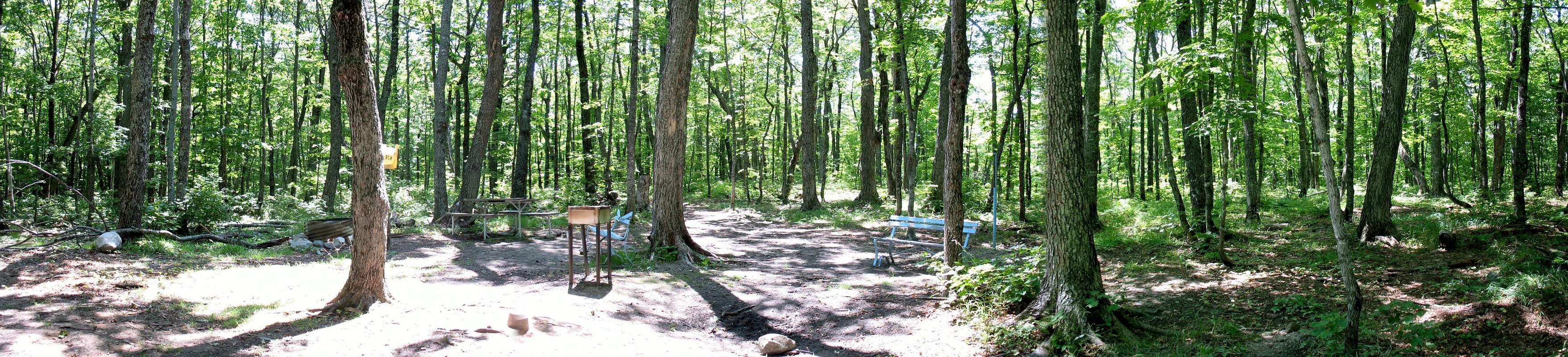
PRIMARY ROUTE:
-From the intersection of US Hwy 41 and Broad Street immediately South of L'Anse, proceed North into L'Anse on Broad Street for 0.7 miles to Main Street.
-Turn right (E) on Main Street which will become Skanee Road, and continue 16.1 miles to Roland Lake Road on the right, where the Zion Lutheran Church is on the SE corner.
-Turn right (S) on Roland Lake Road and proceed 2.9 miles to Ravine River Road at Roland Lake.
There are many less well-developed roads in the Ravine River Road area. Please follow the blue signs that mark the way to the top. Unless indicated below, stay on the obvious "main track" as you proceed along Ravine River Road. The route on Ravine River Road is as follows: (at this point reset the odometer).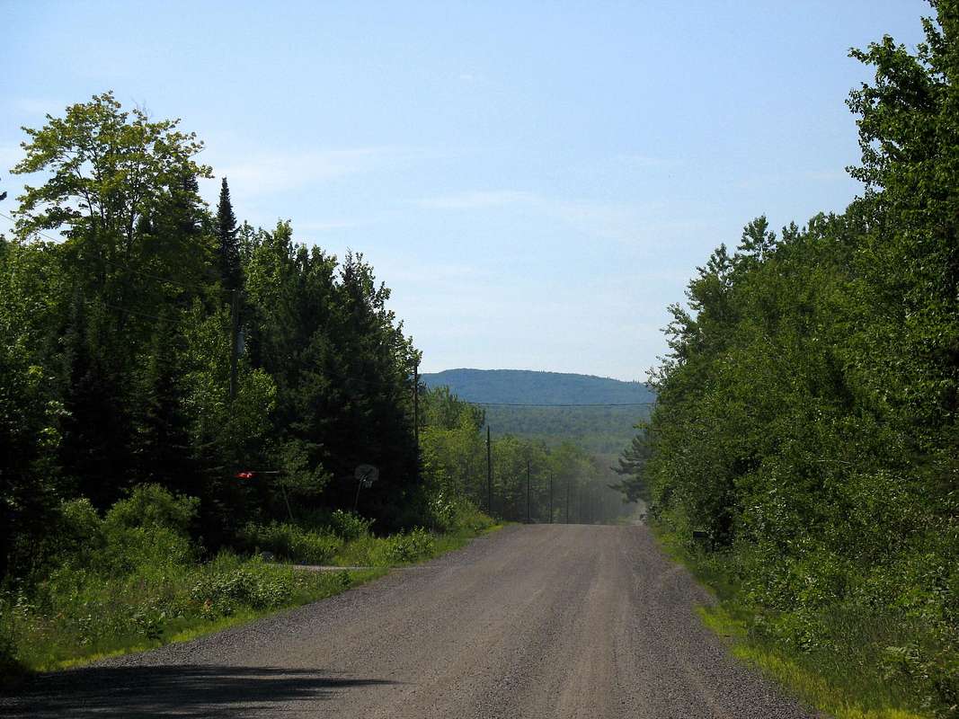
-At 0.7 miles, fork, go straight
-1.8 miles, pass through gravel pit
-2.0 miles, leave gravel pit at a fork, go straight
-3.0 miles, fork, bear left
-3.4 miles, fork, bear right
-4.0 miles, 4.5 miles and 4.7 miles, forks go straight
-6.1 miles. T-intersection, main road goes left, turn right (S)
-6.3 miles fork, go left
-6.4 miles, steep incline at the point, fork, go right
-6.8 miles, fork, go right
-7.2 miles go to right. At this point there is a parking lot and there is an approximately 1/2 mile walk to the summit.
These directions were printed before improvements had been made on the road. If you find that any of these directions differ from signage along the way, please follow the signs!
From the parking area a wide fairly level trail winds 1/2 mile to the summit. Only a few years ago this trail was a road (in the loosest sense of the term) that, with a 4-wheel drive, you could drive a vehicle to the summit on. There are a few moderately steep sections but nothing serious. You'll know the summit when you get there - a large blue marker and two blue benches mark the summit. Don't forget to sign the log book inside the small, steel mailbox attached to the summit marker!
Visit the Indian Country Sports website below. There is also a map of the route at this site.
White Tape
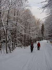
Winter Ascent
I call this section White Tape instead of Red Tape because there is no red tape. The summit and access road are free to anyone who decides to visit them. Most of the surrounding land is paper company land and undeveloped.
White Tape refers to the restrictions mother nature places during the region's longest season - winter. The U.P. is famous for its snowfall. Between late October and April up to and above 300 inches of snow can fall on the Huron Mountains. By early March the snow can set 6 or more feet deep in places. Roads can remain snow-covered well into May. Once the snow finally melts then comes mud season. It usually takes until early June for the ground to thaw and absorb that 300 inches of melted snow.
After that though you have a good 3 or 4 months unrestricted access before the snow flies again!!!
Obviously, very few people visit the summit in winter. It is a long 8 mile snowshoe or cross country ski trip to the summit (one way!). Another option is bringing or renting a snowmobile. The U.P. is some of the best snowmobiling country anywhere and numerous trails criss-cross the area. You can pik up a trail map at almost any area gas station.
Camping & Miscellaneous
I noticed numerous campfire rings near the road on my way to the summit but am unsure as to specific rules regarding camping in the area. If you have any info regarding this please contact me so I can include it here. The surrounding area does have numerous state and national forest campgrounds. Please call or visit the Baraga County Tourist Info Center below for more info...

Baraga County Tourist Information
755 E. Broad Street
L'Anse, Michigan 49946
906-524-7444
or visit thier website below!
External Links
- Mt. Arvon Page
Info on Mt. Arvon from Americasroof.com. Also has trip reports. - Baraga County Tourist & Recreation Association
Anything you need to know about Baraga County including Mt. Arvon. - Indian Country Sports - Mt. Arvon Page
Detailed directions to Mt. Arvon along with a useful map of the route.
DWhike's Adventures - Shameless self promotion...come visit my website for more pics of Mt. Arvon and other places that I have wandered off to in recent years... 
Redwic - Jul 7, 2008 11:45 am - Hasn't voted
No more 1/2-mile hike...The "fairly wide level trail" leading 1/2-mile from the parking lot to the summit has changed. The 1/2-mile jaunt is a drivable unpaved road leading to an open parking area next to the summit entrance... A person only needs to walk about 40 feet into the trees to reach the summit, now, with no elevation gain on foot. (On my personal list of Difficulty Ranks for State HPs, I am dropping the difficulty of this HP from #24 to #47, as a result of this route update...)
dwhike - Jul 9, 2008 9:42 am - Hasn't voted
Re: No more 1/2-mile hike...This is very interesting news...I was up there last year and it was still very much a trail. Can't say I'm happy about the change...
Marcy725 - Jul 29, 2009 4:51 pm - Voted 10/10
Re: No more 1/2-mile hike...I was just there on July 25th, the road is not drivable unless you have a 4 wheel drive with high tires to get over the blockades they have up.
Redwic - Jul 7, 2008 11:56 am - Hasn't voted
No reference to "Church Road"..."Church Road" is not referenced on any street sign. The street sign says "Roland Lake Road", and a small church is located at that street corner.
dwhike - Jul 9, 2008 9:39 am - Hasn't voted
Re: No reference toNoted, I'll make the change right away...thanks!
Marcy725 - Jul 29, 2009 4:55 pm - Voted 10/10
viewArticle states there is no view from the top. That has changed, they have cleared trees and there is now a short path from the summit with an nice overlook.
dwhike - Jul 30, 2009 1:56 pm - Hasn't voted
Re: viewThanks!! I had asked around about mysterious reports of a view but received no response. I'll make the update as soon as I have time. Out of curiosity what direction does the overlook face (i.e. Lake Superior or the Huron Mountains)? If you have any pics they'd be more than welcome! Regards, Dan
hanobert - Jul 9, 2013 6:06 pm - Voted 10/10
Great AdventureI would definitely recommend the Mt. Arvon high point. I headed up there today and even a bit overcast, the view was still great. The benchmark and the register are fun to look through. I did not see a reference to Church Rd., it was still Roland Lake Rd. Also, the trail was only a few hundred feet to the benchmark and a few hundred more to the view from the parking area. Very easy access once you reach parking.
HuronBayGuide - May 10, 2014 8:51 pm - Hasn't voted
View from Mt. ArvonAbout 3-4 years ago, the trees were cleared near the NW summit of Mt. Arvon providing a nice view over Lake Superior's Huron Bay, Abbaye Peninsula, Keweenaw Bay and the Keweenaw Peninsula. I own a cabin on the shore of Huron Bay, about 15 miles by logging roads north of the summit, and often take guests to the top of Mt. Arvon.
Colin - Aug 11, 2015 5:40 pm - Voted 9/10
Scout Your RouteI visited on 8/4/15. The directions above are good and the little blue signs help (where they are't overgrown), but I was glad that I had scouted the route on Google Earth. It's a tangled network of dirt roads and it helped to have some landmarks, such as the quarry area and the "beaver dam" to reassure me I was on the right track. Nice set up at the top, but it was too cloudy and wet for me to see Lake Superior.
gcrain - Jun 8, 2016 6:06 pm - Hasn't voted
Road Washed Out - 1-mile hikeMy wife and I drove to Mount Arvon this weekend (6/5/16). The directions from Summitpost.com were perfect! It is very well marked with those great blue signs. However, at the very last turn the road had washed out. A beaver dam that abuts the road had overflowed and the road has large ruts in it. I do a lot of off-roading, and I would not attempt this wash-out except in a serious, high-clearance 4WD vehicle. The wash-out is approximately 1 mile from the summit. The road is not steep and is very obvious. It is a lovely(!) walk and well worth it. So don't turn around at the wash-out. Park your vehicle and do this wonderful walk. Also, make sure you take a little N-NE-ish diagonal trail from the summit. There's a lookout with a great view and a highpointers.org bench to sit on and enjoy it. (I've posted pictures on this page, as well.)
Hamel512 - Jan 31, 2017 7:46 pm - Hasn't voted
Any guides or Snowmobile rentals?Hello! I have an opportunity to visit in about a week and a half. I wanted to see if anyone out there knows of any snowmobile rentals? I would love to check this one off, but I think it would be best this time of the year to not drive/hike. I am also willing to use an 'unofficial' rental source like a local family that would be willing to rent me one and perhaps accompany me. If anyone has contact information, that would be appreciated.
maddie77777 - Jun 5, 2017 10:28 am - Voted 10/10
Road goes to the topAfter the 7.2 Mile Marker point, it's another 1.1 miles to the very top, where they have a small turnaround for cars. So total distance is 8.3 miles from the point you reset your odometer. Thanks!
rbirk - Sep 19, 2017 6:15 pm - Hasn't voted
Sep 2017Drove up the road last Sat (Sep 16) and then road was mostly fine for a small 2-wheel drive car. Some potholes you could drive around if you go slow. I parked by the little pond .4 miles or so from the summit (with small area to park). Wasn't sure how the last part would be and it was nice to move the legs a little. I think it would have been fine to drive the whole way up. Good place to park and so. The road has some steeper sections going up and you don't want to lose momentum going slowly uphill, but I made it fine with my small car.
tdmowery - Mar 18, 2018 10:25 am - Voted 7/10
Want to do Arvon in winter?Call ahead to Tracy at L’Anse visitor center! She helped us rent snowmobiles and a guide to the summit. Made Mt Arvon our favorite Highpoint to date!
MountainHikerCO - Jun 10, 2018 2:18 pm - Hasn't voted
Caution: Hiking Trail / Trailhead Parking Signs lead up wrong roadWe visited Mt Arvon on May 31, 2018. The blue signs were very helpful for finding our way through the maze of back roads. However, on the outside of a left turn about 2 miles short of the summit there are some misleading signs. "Mt Arvon Hiking Trail 1-3/4 miles," "Trailhead Parking" & "Follow Blue" (with a blue diamond & a straight arrow pointing up a lesser side road.) Do not follow this side road. Stay on the obviously more maintained road that turns left. There apparently is some sort of overgrown tick gauntlet they are passing off as a hiking trail, but we didn't see it. We did hike over a mile back this 4WD rough, puddle saturated side road before deciding it couldn't be right. Then with several tick passengers and directions from a chance encounter, we drove the rest of the way to the summit parking lot. The correct road was passable in a Dodge Caliber, but some places were mud rutted and required a lot of care. I wouldn't want to try those same stretches when the mud was soft. It would be great if a clarification arrow were added to this group of signs to indicate the correct direction for driving.
richh - Jul 1, 2018 11:50 pm - Hasn't voted
Re: Caution: Hiking Trail / Trailhead Parking Signs lead up wrong roadYou obviously missed the trail, but for a very good reason. It doesn't exist yet! (and maybe never will.) I put a full report and gps track on peakbagger.com.
justinmeats - Jul 23, 2018 1:57 am - Hasn't voted
Easy drive in 2w drive carWe made it to the top on 7/22/18 just fine in a Mazda 6. There are a few potholes and rocks sticking up out of the ground. The instructions on here are very good. DO NOT use Google Maps to get to the top or to go east from here in Michigan. We followed Google Maps east and the roads kept getting worse, finally had to turn around. It added about 3 hours to our trip. Plan on driving back through L’Anse.
JustHeiges - Jun 9, 2019 9:10 am - Hasn't voted
Re: Easy drive in 2w drive carThis post was spot on, from a fellow Justin. We tried to take Northwestern Rd from the east to Mount Arvon. It continued to get worse until we had to turn around due to road blockage. Would recommend only coming from L'Anse.
lime - Sep 25, 2020 5:57 am - Hasn't voted
Additional mileage notesWe were able to drive up to the parking lot - we had a Jeep, but people in the parking lot had sedans. We noted that after the above directions stop, we followed the blue sign at 7.2 (forgot to write down if L or R, but I believe L) , forked right at 7.9, and arrived at the parking lot at 8.2 miles.