
-
 94337 Hits
-
 91.66% Score
-
 36 Votes
|
|
Mountain/Rock |
|---|---|
|
|
41.00720°N / 104.0305°W |
|
|
5429 ft / 1655 m |
|
|
Overview
Though the State of Nebraska is home to many buttes and even the southern terminus of the Dakotas' Badlands, its highpoint is in the middle of a nearly featureless field just over 1 mile away from the borders of Colorado and Wyoming. Panorama Point, at 1,655m (5,429ft), features geology very similar to that of the Southern Great Plains of East Colorado, Kansas and Oklahoma; the land has been shaped through rainwater runoff and especially human hands / machinery. While this highpoint is atop a hill, it is difficult to tell exactly where the true highpoint is. Were it not for the marker placed by the Kimball Chamber of Commerce, one would have a very difficult time locating the true Highpoint of Nebraska. Be sure to open the drawer of the large metal desk next to the monument marker and sign in to the register notebook within. Recently a bench was placed next to this looking west to the distant mountains of CO and WY, easily visible on a clear day. Wind and hoof erosion has caused ground level to drop 6-8" all around the highpoint, exposing the concrete footings to each of these features. Gravel is being brought in to fix the situation in the summer of 2016. |  |  |  |  |
Getting There
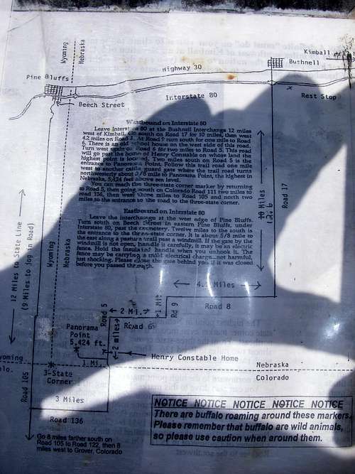
-Take Exit 8, just East of the WY-NE border
-Go S on CR 17 for 10.0 miles until dead-end
-Turn W (R) on CR 8 and continue for 4.2 miles
-Turn S (L) on CR 9 and continue for 1.0 miles
-Turn W (R) on CR 6 and continue for 2.0 miles
-Turn S (L) on CR 5 and continue for 2.0 miles
-Turn W (R) on dirt road with sign, cross double cattle guard (for bison!) and continue for 1.0 miles to a bend to the right (NNW), and continue0.2 miles to the highpoint marker
Directions from Pine Bluff, WY:
-Leave I-80 on US 30 to enter the town of Pine Bluff (north side of I-80).
-Go south on Beech Street, which is on the east side of town. This is county road #164.
-Pass under I-80 and go about 9 miles to road #203 leaving left (east).
-Follow this road, which jogs south and becomes road #6, for 3.4 miles.
-Turn right (south) on road #5 and go 2.0 miles.
-The dirt road to Panorama Point leaves right (west), just a hair north of the Colorado state line. From the road sign, it is 1.2 miles to Panorama Point.
 |  |
Red Tape
Panorama Point is on the High Point Bison Ranch and is owned by Glen and Jill Klawonn. The Klawonn's are extremely welcoming to highpointers during the day, and at night the gate to the highpoint is left open. The Klawonn's request a donation of $3.00 for visiting the highpoint, which can be placed in a box near the final turnoff to Panorama Point. The Nebraska-Colorado-Wyoming tri-state marker is also located on the Klawonn's porperty, however, due to the fact that open buffalo range must be crossed to get there, they request that visitors do not hike from the highpoint to the marker. Please respect the Klawonns' wishes and approach the tri-state marker from the road to the west.
The area receives a fair amount of rain and snowfall, and at times in the past this has caused the 1.2 mile access road to be closed for safety. Many visitors come from across America and are very disappointed to learn that not only can they not drive out to the highpoint, but they are asked to not walk the road either. Please respect the property owner's requests! This is private property, and visitors are allowed in most of the time, but the road is closed for public safety. The bison are frequently within the fences of this section, and it would be dangerous to walk the road the entire way without the safety of a vehicle nearby.
The Klawonns are working with The Highpointers Foundation, a non-profit organization that is a sister entity to The Highpointers Club, to make road improvements. Some gravel was placed on the road in 2014, and in 2016 the road will be bladed by a grader, and additional gravel placed in the low spots, such that the road will go from a dirt 2-track, to a decent gravel road. This should reduce the annual closure days from 20-30+ down to perhaps under 10 a year during periods of big snowfall and drifting during winter. The Klawonns will alert the Kimball NE Chamber of Commerce as well as the HP Club and Foundation when there is a closure. These organizations have websites and Facebook pages that should have the info posted.
Miscellaneous Info
After "ascending" the Nebraska highpoint, you can contact the Kimball, NE Chamber of Commerce for a certificate of completion for visiting Panorama Point. A side-trip can be added to Pine Bluffs, WY for those wanting to get some true hiking near Nebraska's highest land. The Pine Bluffs are visible in the distance from the "summit". |
External Links
- Winter Ascent of Panorama Point
A winter "climb" of Nebraska's highest point.
- America's Roof Guide to Panorama Point
An information page on Nebraska's highpoint maintained by the Highpointer's Club.
- Nebraska high point page
This page contains directions from Denver, Colorado, as well as photos.
- Return to Thick Air
A very amusing account of visiting Panorama Point.
ChaddBragg - May 8, 2005 11:40 pm - Hasn't voted
Untitled CommentThey are now requesting $2.00 at Panorama Point.
Alpinist - Jul 31, 2006 5:18 pm - Voted 9/10
Access feeJuly 22, 2006: The access fee is now $3.00 per person.
Corax - Aug 26, 2007 1:55 am - Hasn't voted
LinksHi! It seems like the two links to the winter ascent pages don't work. Here's a link to a story about an expedition to Panorama Point - Return to Thick Air http://dim.com/~jbettin/air/ne000.htm
txmountaineer - Sep 5, 2007 3:18 pm - Hasn't voted
Re: LinksThanks you very much for finding this! I've made the changes to the page. Daniel
Jeremy Hakes - Jun 3, 2010 10:38 am - Voted 10/10
From ColoradoMay I suggest adding directions from Colorado to the "getting there" section?
txmountaineer - Jun 22, 2010 10:48 am - Hasn't voted
Re: From ColoradoJeremy, If you can provide them, I will happily add the directions to the page. Thanks! Daniel
moneal - Aug 26, 2018 3:10 pm - Hasn't voted
Re: From ColoradoI recently came in from CO and it worked great using these directions. If you just put in Panorama Point, Google Maps will try to send you down a road that isn't a road (aka County-138) North on CO-71 through the Pawnee Natl Grassland Left on County-132 (dirt) - Note Google Maps called this Tower Rd RIght on County-135 (dirt) - 132 dead ends into this road Left on County-134 (dirt) - Make sure you put a waypoint here for Google Maps Right on County-111 (dirt) - 134 dead ends into this road Left into Panorama Point All of the roads are fantastic and easy in any car. Go this way for sure if you're coming from CO
Cascade Scrambler - Jun 2, 2011 1:48 pm - Hasn't voted
External links brokenI just wanted to point out that under the External Links, only the link "America's Roof Guide to Panorama Point" is not broken.
Niederbayer - Jun 9, 2014 9:39 pm - Hasn't voted
Coloradofrom Colorado - head to Hereford (right south of Wyoming State Border) head east on CR 136 - pavement ends at junction CR 136/89 - continue until junction with CR 111 - turn left on CR 111 until you cross the state line and you reached CR 5 if the Colorado route makes distance/timewise sense depends on where one starts - if starting from Denver Metro Area it is actually faster to go via the Wyoming/Nebraska route ( as per mapquest) instead of going to Hereford from the Pawnee Buttes one can get to Panorama Point via CR 107,CR 124 and CR 111 - all gravel roads
Niederbayer - Jun 9, 2014 9:45 pm - Hasn't voted
Winter Ascentlink is broken
Bark Eater - Sep 16, 2014 12:02 pm - Hasn't voted
Tri-Point VisitIf you wish to visit the CO-WY-NE tri-point, from the high point turn off the private road, head a few miles south to CO county 136, right (west) a few miles to the next real road intersection, right (north) a few miles to the state border. You will see a fence line perpendicular to the road at the state border, and a closed gate just prior to it. Enter the gate, drive about a half mile along the road trace to the wind mill/stock tank, and park. The tri-point monument is about a quarter mile further along the fence line. I do not recommend driving beyond the stock tank. During our visit this area was quite wet; you would likely get stuck. Well worth the side visit. You can continue back on that public road north to Pine Bluffs and I-80.
DesertLobster - Mar 18, 2023 1:17 pm - Hasn't voted
Closed for snow in March 2023If anyone is looking to visit in the next few weeks, it may be better to postpone. I drove up today and there was a pile of snow in front of the gate and the gate was padlocked. It looks like it will take a few weeks at least to melt!
LazyJSkwires - Apr 2, 2023 7:39 pm - Hasn't voted
Re: Closed for snow in March 2023It was open today, no trouble getting in