-
 52553 Hits
-
 88.34% Score
-
 27 Votes
|
|
Mountain/Rock |
|---|---|
|
|
40.67080°N / 111.683°W |
|
|
10246 ft / 3123 m |
|
|
Overview
Gobblers Knob is located in the Wasatch Mountains, in near proximity to Salt Lake City. This peak is the highest summit on the ridge separating Big Cottonwood Canyon on the south, and Millcreek Canyon on the north. Gobblers Knob is located in the Uinta-Wasatch-Cache National Forest, just outside of the Mount Olympus Wilderness area. Nearby summits include Mount Raymond to the west, and Little Water Peak and Reynolds Peak to the east. With an altitude of 10,246 feet, Gobblers Knob has the distinction of being the highest point on the ridge separating Big Cottonwood Canyon and Mill Creek Canyon.
USGS Quads:
- Mount Aire, Utah (1:24k)
- Dromedary Peak, Utah (1:24k)
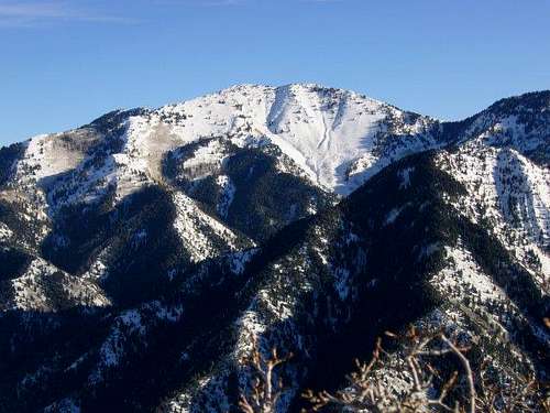
![Gobblers Knob, as viewed from...]() Gobblers Knob from the summit of Grandeur Peak
Gobblers Knob from the summit of Grandeur PeakGetting There
There are numerous trailheads and routes which may be used for a climb of Gobblers Knob. From the north Mill Creek Canyon contains approaches of Bowman Fork and Alexander Basin, while from the south Big Cottonwood Canyon contains approaches of Mill B North Fork and Butler Fork. Two additional appoaches include Porter Fork (Mill Creek Canyon) and Mill D North Fork (Big Cottonwood Canyon), but these approaches are longer and less commonly used.
The most popular trailheads for ascending the peak are as follows:
Mill Creek Canyon:
Bowman Fork Trailhead
From I-215 heading on the east side of Salt Lake Valley, get off on the 3300~3900 South Exit, this will put you on Wasatch Blvd. Follow the BLVD and turn right onto 3800 South, look for signs to Mill Creek Canyon. About 5.3 miles up the canyon you’ll come to Terrace Campground on the right. Turn into the campground area and follow (0.2 miles) around to the back to the campground to the Bowman Trailhead.
Alexander Basin Trailhead
From I-215 heading on the east side of Salt Lake Valley, get off on the 3300~3900 South Exit, this will put you on Wasatch Blvd. Follow the BLVD and turn right onto 3800 South, look for signs to Mill Creek Canyon. About 8.5 miles up the canyon you’ll arrive at the Alexander Basin Trailhead, located on the right (south) side of the road. There is a very small area for parking along the road at the trailhead.
Big Cottonwood Canyon:
Mill B North Fork Trailhead
From the 6200 South exit off I-215, head east and south on State Highway 190 for ±2 miles to the intersection with Big Cottonwood Canyon road. Turn left at the intersection and drive approximately 5 miles east to the "S" turn in the road, and park on the right. The trailhead is located on the left side of the road a short distance to the north of the parking area.
Butler Fork Trailhead
From the 6200 South exit off I-215, head east and south on State Highway 190 for ±2 miles to the intersection with Big Cottonwood Canyon road. Turn left at the intersection and drive approximately 8 miles east to the Butler Fork Trailhead and parking area, located on the left side of the road.
See the corresponding 'Routes' sections for details on climbing the peak from each of these trailheads.
![]()
![]()
![]()
![]()
![]()
Red Tape
Mill Creek Canyon is a fee area. A toll booth is located approximately 1.5 miles up the canyon, and collects a fee of $3.00 per vehicle as you exit the canyon. Annual passes may also be purchased for $40.00.
Prior to June 1 each year, a locked gate on Mill Creek Canyon road prevents driving the final 2.4 miles to the Alexander Basin trailhead. After June 1 the gate remains open until the first significant snowfall of the season.
No fees are required for approaches from Big Cottonwood Canyon.
When To Climb
Gobblers Knob can be ascended year round. Dry hiking can usually be found on the mountain by early to mid June, depending on the snowpack, but snow may linger considerably longer on the north facing approaches from Mill Creek Canyon.
Winter months allow for good backcountry skiing on the mountain. Depending on the route and snowpack, gear from basic snowshoes to crampons and ice axe for the various chutes might be required. There are numerous avalanche slide paths on the mountain; carefully assess snow conditions before considering a winter attempt.Mountain Conditions
- National Weather Service forecast .
- Weather forecast and current conditions for nearby Brighton Ski Resort.
- Utah Avalanche Center website.