

-
 37717 Hits
-
 85.13% Score
-
 20 Votes
|
|
Mountain/Rock |
|---|---|
|
|
14.75696°N / 91.55173°W |
|
|
Hiking |
|
|
Winter |
|
|
12375 ft / 3772 m |
|
|
Overview
Santa María volcano is part of the volcanic arc that runs all along the coast of Guatemala. Prior to the Spanish Conquest it was called Gagxanul in the local K’iche’ language. The main attraction for most non-locals is the view from the top of the active Santiaguito lava dome (2510 m) which grows within the large outward-facing crater that formed during Santa María's cataclysmic eruption in 1902. This eruption was one of the largest of the 20th Century, associated with strong earthquakes and dispersal of pumice and ash over a huge area. Thousands died during the eruption and from malaria. Prior to the 1902 eruption there had been no activity for several hundred years. The normal route to climb Santa María starts from the outskirts of Quetzaltenango city, also known as Xela. The path up the cone passes through subtropical and then pine forest and is fairly steep overall but easily manageable due to the well maintained switchbacks. The summit region is a large open area of rocks and boulders which offers great views of the surrounding volcanoes and of Santiaguito. Many people climb it daily, as the summit is also a place for Mayan ceremonies conducted by local people. Many of the photos and figures on this page were submitted by others so thanks to them for helping illustrate this amazing place. Thanks also to bartjansen for starting this page.
 Santa María from NW
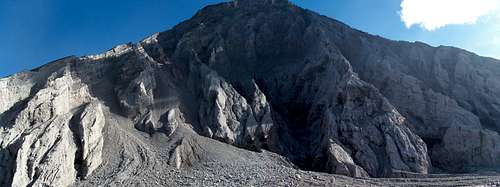 Santa María from the south-west
 View from Santo Tomas (SE)
Getting there
Getting there: Quetzaltenango is the ideal base for a trip. There are many ways to get to the trailhead including taking taking a southwest bound bus (2 quetzales, US 25 cents) or taxi (60 quetzales, US$7.50); ask for Llano del Piñal, which is on the northern base of the volcano (7 km away, ~2500 m asl, see map below) and/or Chicavioc which is a little closer. Note that 'Rio Seco' as shown on some older Google map images refers to a dry river bed that runs through the area rather than a specific place. If you drive to the regular trailhead, either get dropped off or find someone locally to look after your vehicle, don't just leave it by the roadside. Hitching rides or paying someone to drive you there or back is also possible if you're bored of waiting for buses or if you've missed the last one. Drive time is ~ 30 minutes. If you have something with 4-wheel drive you can actually save an hour or so of hiking by following the rutted-track that heads west from Chicavioc and then curves back round to the south and then east till you get to La Mesa (see the annotated figures in the Routes section below). Note that you would want to be getting dropped off as leaving your vehicle up there might not be the best. Also this route has so many offshoots that you'll need good directions or try using Google Earth.
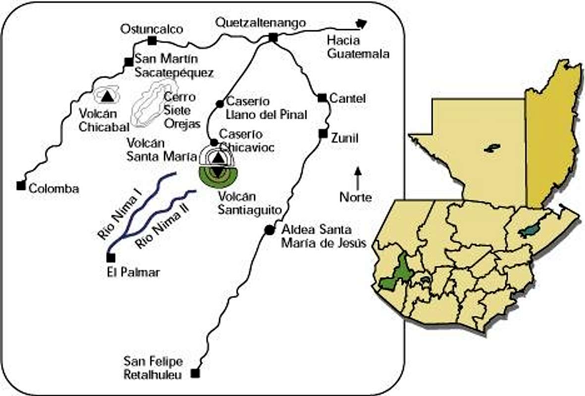 Regional towns
View Larger Map (if no image above, right-click area and refresh)
Routes
Santa María summit
The climbing time to the top is 3 - 5 hours depending on how much you're carrying and the descent time is approximately 2 - 3 hours. From these settlements of small houses, farmland, a bus stop and a local shop you continue on the road towards the volcano. After a few minutes from Chicavioc the road will change into a path (picture 1 below) through steep farmland and into forests. After about an hour you reach an 'La Mesa', an open grassy area/field surrounded by trees. At this point the volcano cone is on your left (east). You can miss it easily if there is thick cloud cover as you would perceive the mist above the trees as open air. Leave La Mesa in an easterly direction and continue till you hit a big sign and some wooden constructs. (There is actually a shortcut a little ways back down the main approach path that brings you to the same point, see route figure below).
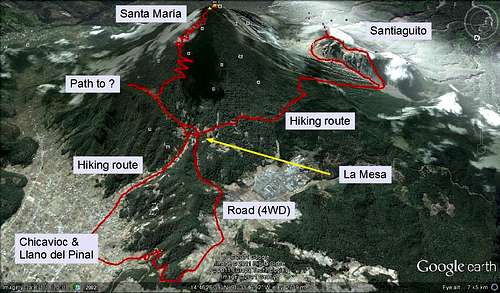 Potential routes
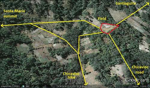 Area around La Mesa
Regardless, from here take a right and the path which heads up the cone. You can't really get lost, just follow the obvious trail as it goes upward. The path is essentially a mixture of dirt and rocks and can get muddy if wet. Due to the gradual slope of the land it can look like you are near the top for quite some time before you actually get there. It's only when you break form the trees that you will be within 15 mins. At the top you get a great 360 degree view including many other volcanoes in the arc such as Tajumulco, Tacaná and Fuego, which you might spy an eruption from. When approaching the summit pay attention to details indicating the return direction as it's very easy to become disorientated while up there given the number of paths. As this is a busy trail however feel free to ask anyone for directions.
 Trail head Trail head |
 Route to junction Route to junction |
 Junction to cone Junction to cone |
 Climbing Climbing |
 Still climbing Still climbing |
 Still climbing?! Still climbing?! |
 Summit! Summit! |
 Ceremonies Ceremonies |
 Patience... Patience... |
 Tajumulco and Tacaná Tajumulco and Tacaná |
Santiaguito viewing: To get the best views of Santiaguito you'll want to head down towards Santa Maria's crater. If you follow the ascending path over the summit and down again, where it starts petering out, keep going down but work your way a little to your right. Go through some trees and you'll come out onto an open area with rocky outcrops from which you can get the full experience. The spot mentioned isn't right at the edge, it's a little above and back but of course you can get as close to the edge as you want. Just remember it's a 1300 m drop, and pretty unstable. It may be possible to hike along the edge of the crater all the way down to the moat area between Santa María and Santiaguito but couldn't say for sure. At night you can get nice views of incandescent activity as it's usually cloud free, just remember to dress up warm.
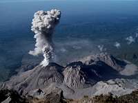 Santiaguito overview
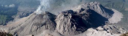 For close ups
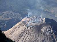 El Caliente surface
Video of morning view from top of Santa María down to Santiaguito.
Getting to Santiaguito
From the main crossroads (La Mesa) shown in the route figures above you can continue southward through a complex network of paths to 'El Mirador' which gives you a good look out over Santiaguito if the weather is clear (similar to that below). Many of the paths lead to the same place but it's not particularly obvious as they were made by locals for various other purposes. The position and rough route are marked on the topo map below. If going solo my main tip is that when you come to a big fallen tree that you take a left and go round the back of it rather than taking the more obvious path in front of you. It takes about 45 minutes to get to 'El Mirador' from La Mesa, and then several more hours to get to Santiaguito if you're up for it, it's certainly recommended. See the main Santiaguito page for more specific route info including some GPS coordinates. Proceeding this way will also get you to Santa María's exposed face which is heavily eroded and prone to rockfall.
 Area topo map
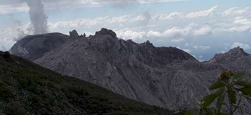 View of Santiaguito from El Mirador
 Approaching Santa María's crater
Guide information: While you don't really need a guide to get to or up Santa María there are options available. Some examples I found listed on the internet during a brief search are listed here, the latter two of which are listed in Lonely Planet's Guatemala book.
When to climb and Weather
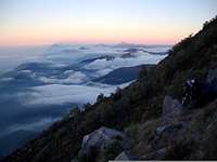
During the dry season (November to April) climbing conditions on the steeper parts of the climb will be much easier as the muddy paths will be drier. The views will also be considerably better as cloud cover will tend to be restricted from ~10 AM to 5 PM. This is a considerable change to days gone by when the dry season meant no clouds. The clouds will often be more focussed on the oceanic side of the mountain but there may be times when the whole mountain is enveloped or relatively cloud free (you can see I've had a mixed experience. Winds can also be quite strong, it's not unknown for tents to collapse. Temperatures may be extreme during the dry season, ranging from freezing at night to 30 C / 90 F during the day. There is a chance of a slight rain too if there are clouds about. During the wet season expect persistent cloud and a lot of rain. Not really worth going if you want to have a good time. Compare the photos below for an idea of the difference between seasons.
 Dry season morning, clear
 Dry season day / wet season
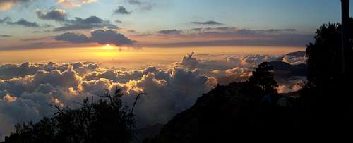 Dry season evening, clouds dispersing
Camping and Dangers
There aren't any restrictions to camp in the forest or on top of the mountain, nor are there any huts or fees. Note that people camping on the summit previously have been robbed. There are plenty of places you can camp off the summit which might afford you better protection, but no guarantees. There are no tourist police around unless you hire them yourself. You're pretty safe from any volcanic activity from Santiaguito but might get a bit of ash coming your way depending on the wind direction. There are no water sources unless it rains on you.
Also, from mmcguigan: "Recently drug runners have been using the lower portion of this trail as they carry cocaine and other substances to Mexico. There have been a number of gun battles between these criminals and the military. Don't let this stop you from climbing this wonderful volcano but be careful and don't leave the trail - especially in the lower sections."
Adrenalina Tours and Quetzal Trekkers (see links above) have offices in town which may be able to provide up to date information on things going on. Click the 'Contact Info' links on their websites for addresses.
Note also that the summit of this mountain is approaching 4000 m and some people may find the altitude a problem, particularly if they haven't acclimatised in the area.
There are a couple of camping spots (i.e. bits that are flatter than others) down around Santiaguito also, one in the lower moat to the left of where you reach the open, and one in the upper moat, again to the left of where you reach the open, on a raised platform. There are two good spots on Santiaguito itself, one between the tops of Brujo and El Monje domes, and one close to the top of La Mitad. There are no reliable water sources down there in the dry season to my knowledge, but there's the odd river on the map and depressions in which water might collect. Best taking all supplies with you.
External Links
- GVP Santa María / Santiaguito page
- MTU Santa María page
- A gripping first hand account of the eruption and the events leading up to it by G. Eisen.
mmcguigan - May 11, 2008 5:48 pm - Voted 10/10
CAUTIONRecently drug runners have been using the lower portion of this trail as they carry cocaine and other substances to Mexico. There have been a number of gun battles between these criminals and the military. Don't let this stop you from climbing this wonderful volcano but be careful and don't leave the trail - especially in the lower sections.
Tim Geerlings - May 26, 2010 4:10 pm - Voted 8/10
Getting thereWhile Google maps calls the town Rio Seco, anyone in Xela knows Rio Seco to be a dry riverbed that runs through all of the city, not the town at the base of the volcano. If taking bus(2 quetzales, US 25 cents) or taxi (60 quetzales, US$7.50), ask for Llano del Piñal, should get you to the base.
Baarb - May 27, 2010 7:22 am - Hasn't voted
Re: Getting thereHi there, thanks very much for the info clarification! The previous page iteration had referred to Llano del Piñal also and have integrated all the information I have available. Please feel free to contribute or suggest anything else that you think will improve the page.
zola - Aug 13, 2014 12:04 pm - Voted 7/10
Starting at Llano del PinalHi, I just did this hike yesterday. Just for clarification, taking the chicken bus to Llano del Pinal starts you off on a northeasterly approach from the far left side of your trail map of potential routes. Basically, it means you join the main path from the east (labeled "Path to?" in your trail map). To get to this path from Llano del Pinal (No tilde over the "n"), you follow the main road south from where one gets dropped off to hike Santa Maria. After about 1 hour, the trail(s) approach a grassland plateau between Santa Maria and a small mountain ridge. Before actually arriving at the top of the plateau, you veer right towards Santa Maria, following a deep ditch-like trail littered with white gravel and rocks on either side (appropriately referred to as "túnel blanco"). There is a large tree with a white arrow spray-painted on the bark in the woods where you join the main path going up about 20-30 minutes after veering right. I would recommend relabeling "Chicavioc & Llano del Pinal" to just "Chuicavioc" to avoid confusion, and it would be helpful to label the far left side "Llano del Pinal." You could then also change "Path to?" to "Path from Llano del Pinal." Thank you for this great write-up. Please make the corrections above, as apparently others have gotten temporarily lost on their guide-less hikes looking for the trail from Llano del Pinal.
Baarb - Aug 13, 2014 10:24 pm - Hasn't voted
Re: Starting at Llano del PinalHi there, thanks for these comments and your others on the photos/diagrams. I will look to make the corrections you have suggested. Cheers.
Storm2 - Mar 25, 2017 9:26 am - Hasn't voted
Update January 2017In January 2017 the trail was in good shape. Here are a few reference points that might make routefinding easier. - Get off the bus at Llano del Pinal (end of the line) and walk to QUATRO CAMINOS, a junction where the main street turns into a rocky path, and take the path. - Walk through fields, stay on main path, ignore any junctions/dead ends going into fields. - IMPORTANT: there is one critical junction on the trail. Shortly after the path enters the forest, you'll come to a fork. Go LEFT, uphill on a less obvious path (right goes to the other side of the mountain where people got lost). - Reach a flat grassy area and go right. - From here it's a straight shot to the summit. Bring hiking sticks, the trail is very muddy when the morning frost melts. I recommend camping on the grassy meadow or on the summit to fully enjoy the night sky and views of Xela and Santiaguito. There is little shelter on the summit, though.
MjSt - Mar 17, 2019 7:46 pm - Hasn't voted
Route to El MiradorThanks for this very helpful description! We went to Santa Maria today. As we hiked Tajamulco yesterday, we thought the summit would be a bit too exhaustive, so we decided to hike up only to El Mirador to see Santiaguito erupt. Getting to the starting point is really easy by bus. We took the southward bound bus at Iglesia El Calvario and hopped off at the final stop in Llano de Pinal. From there it's only a short walk southward (following the main road) to the start of the trail. Getting to La Mesa from there is easy: just climb the obvious rocky path and don't enter any farmland. Getting to El Mirador from there is a bit more tricky though. We never saw the fallen tree as desribed in the text - even took a few wrong left turns that brought us to a private terrain and to a secret lumberjack spot. My main advice would be to stick mostly to the right. The route to El Mirador from La Mesa is quite flat. If you face any long (+5 minutes) hikes up or down, you've probably taken a wrong turn. We had to climb two low wooden fences to get to El Mirador as well. In the end, it was really worth it. El Mirador is very quiet and has retained its natural feel (no fencing, artificial platforms, or anything). And the view over Santiaguito is amazing!