
-
 54804 Hits
-
 87.31% Score
-
 24 Votes
|
|
Mountain/Rock |
|---|---|
|
|
38.99200°N / 106.12405°W |
|
|
Chaffee & Park |
|
|
Hiking, Scrambling |
|
|
Spring, Summer, Fall, Winter |
|
|
13326 ft / 4062 m |
|
|
Special Note
Buffalo Peaks | JonBradford
2 July 2012
I have adopted this page with the blessing of the original author, Jon Bradford. I have done my best to update much of the tactical information and freshen the layout while maintaining the solid foundation and descriptive prose provided by Jon. I will also add a detailed description (including GPX data) of the route from the east.
Thank you, Jon!
Sarah
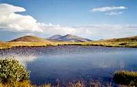
Buffalo Peaks Overview
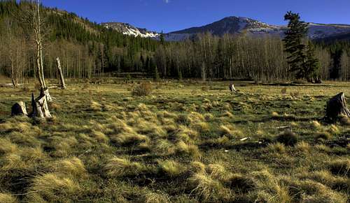
Buffalo Peaks from a meadow | pyerger
| Introduction Text by Jon Bradford |
The Buffalo Peaks are the twin southern sentinels of the relaxed Mosquito Mountains. As such they are the last grand hurrah of the "Greater Park Range". This long mountain chain, although not possesed of a single official nomenclature, is geographicaly contiguous, yet split by two major drainages and a theoretical line of distinction, into several smaller, "official", ranges. The "Greater Park Range" begins in northern Colorado as the rugged Park Range proper, near Mount Zyrkel, which terminates where the Colorado River bisects the range at Gore Canyon. The cordillera continues on south after Gore Canyon as the mighty and majestic Gore Range. It suffers another break at Tenmile Canyon and continues south as the Tenmile Range. Where the Tenmile Range is cut on the perpendicular by the Continental Divide this great range takes on the name of the Mosquitos. Thus East Buffalo Peak, at 13,300 feet, and its higher counterpart, West Buffalo Peak, 13,326 feet, mark the southern terminus of the "Greater Park Range". They rise as two distictive domes visable from both South Park and Buena Vista. Traveling north on 285 I know I am nearing familiar terrain when I spot these friendly mountains. South of the Buffalo Peaks the terrain plunges below timberline and marches off into the amorphus junction of the Sawatch and Sangre de Cristos near Poncha Pass.
As the end of a great range the Buffalo Peaks are a bittersweet farewell to the greatness further north. Yet they stand on their own. They are a distinctive set of domed summits guarded by some handsome cliffs. In marked contrast to the other nearby Mosquitos (or any other summits of the "Greater Park Range") the Buffalo Peaks are volcanic in origin. Twenty five to thirty million years ago a volcanic episode associated with the orogengy that created the Rocky Mountains flooded a prehistoric valley with a deep layer of molten lava (the volcanic vents were likely on the east side of South Park in the Elevenmile Volcanic Field). This valley deposit became a hard layer of basalt. Later the valley deposit was inverted as the continuation of the orogeny hoisted what was once a valley to the heights, along with the long anticline that birthed the Mosquito/Tenmile Mountains. The erosion resistant cap of basalt then protected the Buffalo Peaks as water and ice tore down what the earth had thrust skyward. The Buffalo Peaks of today are the lagacy of this geologic dance.
As befits their volcanic origin the Buffalo Peaks are composed of rock that is both looser and more colorful then the other nearby Mosquitos. The basalt while not necasarily columnated, is distinctive. On closer inspection many interesting hydrothermal mineral deposits can be found. Opaline chert is common in the area. I have found a nice opal on the summit of East Buffalo Peak gleaming in the sun like a piece of irradescent glass.
The Buffalo Peaks are also home to a healthy herd of bighorn sheep. The traverse between the two summits gives many opportunities to view these animals. Below the summits elk, mule deer, and beaver are common. This is a good place to view wildlife in a less stressed setting than the more popular wildernesses.
For climbers the Buffalo Peaks offer a chance to get away from crowds and enjoy something distinctive yet different. Both mountains are but a healthy hike but the hike is memorable. Traversing between the peaks is an ideal juant. The views from the summits of both the Buffalos offers superb views into the heart of the Collegiate Peaks Wilderness and along the crest of the Mosquito Mountains. Fourteen miles north lies the other jewel of the Mosquito Mountains: Horseshoe Mountain. Beyond lies the Mosquito fourteeners: Mount Sherman, Mount Democrat, Mount Bross, and Mount Lincoln.
In recognition of the distinct wilderness qualities of the Buffalo Peaks Congress designated the Buffalo Peaks Wilderness in 1993. This petite wilderness of 43,410 acres is the only designated wilderness in the Mosquito Mountains. Its gentle lower slopes, replete with meadows and beaver damns, makes it a pleasant addition to the wilderness system. The Buffalo Meadows are a sweet series of alpine meadows resplendant with flowers and small beaver damns to the north and west of the high mountains. However the summits the Buffalo Peaks are the wilderness's name de etre and they are worth the climb. They can offer a glimpse of the sublime in a region not known for such transendance.
 |
 |
 |
 |
West Buffalo Peak
 |
 |
 |
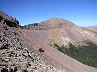
West Buffalo Peak is the guardian of the southern Mosquito Mountains. Its elegant domed summit with its steep east facing cliffs offers a sublime view of the spine of the Mosquitos to the north and the was of the Sawatch to the west. It is 26 feet taller then East Buffalo Peak and seperated by a 12,800 foot saddle. The traverse from East Buffalo to West Buffalo is a worthwhile endeavor. While nothing more then a class two hike the views are outstanding and the cliffs on the north and east side are always there to instill sobriety. The north ridge route on West Buffalo Peak is the easiest way up this mountain and makes an ideal descent route [when combining the two Buffalo Peaks]. - By Jon Bradford
Stamped with the USGS marker titled "Marmot Peak," West Buffalo Peak is a gentle giant from most angles, though its northeastern aspect - carved deeply by an alpine cirque - strikes a more dramatic pose. With nearly 2,000 feet of vertical prominence, along with neighboring East Buffalo Peak, this mountain serves as a bold and beautiful local landmark.
Rank: 372nd highest peak in Colorado
Prominence: 1,986
USGS Quad: Marmot Peak
Rank & Prominence: Lists of John

Getting There
From the East
This access (not really a trailhead) is approximately 15 miles away from Fairplay. The main access point on the east side of the Buffalo Peaks is Forest Service Road 431, also known as the Buffalo Peaks Road. This road is reached by traveling south from Fairplay approximately 12.4 miles or north from the US-285 US-24 junction for 8 miles. Turn west on the signed road and drive 8 miles to a small saddle. Park here. Further on the road descends into the Rough and Tumbling Creek drainage. The Trailhead is not signed. All routes from here do follow old logging roads for some distance but bushwhacking is assured. Enjoy.
From the West
The Fourmile Creek trailhead is roughly 12 miles northeast of Buena Vista. From Main Street in Buena Vista, drive north on CR 371. After traveling 2.7 miles on CR 371, turn east (right) on CR 375 just before the Midland Tunnels. Travel about 7 miles to the trailhead.
Red Tape

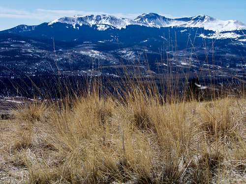
Along the connecting ridge | miztflip
| Generally, there is relatively little red tape in this area. There is no fee to visit this part of the Black Hills National Forest and permits are not required for parking or foot travel. The Buffalo Peaks are located in the Buffalo Peaks Wilderness. Wilderness regulations apply, and include, per the Wilderness Act of 1964: • Only foot traffic is allowed in the wilderness and all dogs must be on a leash. • Motorized equipment is prohibited, including chain saws, battery powered tools, generators, etc. • Mechanized transportation is prohibited, including, including bicycles, hang gliders or carts. • Aircraft, including helicopters, are prohibited from landing, or dropping off/picking up any materials, supplies or persons. Please follow LNT (Leave No Trace) principals: 1. Plan Ahead and Prepare 2. Travel and Camp on Durable Surfaces 3. Dispose of Waste Properly 4. Leave What You Find 5. Minimize Campfire Impacts 6. Respect Wildlife 7. Be Considerate of Other Visitors The nearby South Park Ranger District manages the east side of the wilderness: 320 Highway 285, Box 219 Fairplay, Co 80440 (719) 836-2031 The west side of the wilderness is managed by the Salida Ranger District: 325 West Rainbow Blvd. Salida, CO 81201 Phone (719) 539-3591 |
Weather & Seasons
Summer and Fall are the recommended seasons. Although avalanche danger would not be severe the distance from road closures to the summits in the snow season would make this a much tougher outing.


Camping & Lodging
Car Camping
Camping is allowed in the Buffalo Peaks Wilderness. Many promising sites for car camping are to be had along the Buffalo Peaks Road. More pristine sites can be found further west near the Buffalo Meadows.
USFS Camping
Weston Pass Campground:
• 14 sites
• No reservations (first come, first served)
• $12.00 per night
• Elevation: 10,200 ft.
Fairplay & Buena Vista
A small collection of hotels and bed & breakfasts can be found in the nearby towns of Fairplay and Buena Vista.