
|
|
Mountain/Rock |
|---|---|
|
|
45.3865°S / 167.59090°E |
|
|
4829 ft / 1472 m |
|
|
Overview
Mt. Luxmore is the highest point along the Kepler Track in New Zealand. The Kepler Track is one of the newer tracks in New Zealand, being completed in December 1988. The track was built to relieve pressure off the nearby and very popular Routeburn and Milford Tracks. The Kepler Track has now become popular its self, and since its one of the "Great Walks" of New Zealand, advanced booking for huts and campsites is required.
The Kepler Track makes a 67 km (42 mile) loop "tramp" through some great scenery in Fiordlands National Park. Walking the loop usually take four days. The track starts at the Lake Te Anau Control Gates, goes over the tops of the mountains between the South Fiord of Lake Te Anau and Lake Manapouri, across the top of Mt. Luxmore, and follows the Iris Burn Gorge down to the Waiau River, which it follows back to the trailhead.
The track has a diverse range of scenery that includes lush forest, lakeside and riverside walking, walking long stretches of track above the bushline, and walking through glacier carved and lush U-shaped valleys.
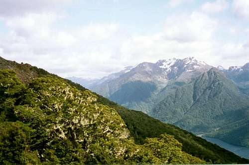
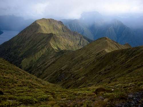 View of Forward Peak from near Mt Luxmore.
Getting There
The track has very easy access, and is one of the most accessible tracks in the area. To get to the trailhead, you must first make your way to the town of Te Anau.
The following bus companies have daily services to Te Anau from Queenstown*.
*International callers dial international ++64-(3) before the following local numbers:
InterCity: 249-7559
Newman's Coachlines
Fiordland Travel: 249-7419
Southern Explorer: 249-7820
Bottom Bus: 442-9708
Once you reach Te Anau, you must check in with the Fiordlands Visitor Center located on the south side of town, on Lakefront Drive, and on the turnoff of the road to Manapouri.
To get to the start of the track from the visitor center, you can either walk or take a shuttle from many of the hotels and hostels in Te Anau. The trailhead is 4.6 kms (2.9 miles) from the visitor center. Take the Manapouri Road south to the first turn on the right, follow it past the golf course to the next right, and follow that road to the trailhead. The trailhead is located very near the Lake Te Anau Control Gates and is well signposted.
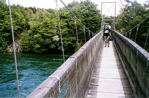 Crossing the bridge near Rainbow Reach.
Route Overview
This is just an overview, so see the detailed ROUTE DESCRIPTION for much more detail.
The trip up Mt. Luxmore and along the Kepler Track is normally walked in a four days and done as a loop trip. This is the recommended route, and is how this route description will be presented. The DOC recommends that the loop be walked in a counter-clockwise direction. This enables you to get the weather forecast from the hut warden at the Mt. Luxmore Hut before doing the alpine section. The loop can be shortened by one day by exiting the trail at Rainbow Reach off the Manapouri Highway, but spending the night at the Motorau Hut and completing the loop is recommended. You are given a discount for the last night's hut fee, and the setting right on the shore of Lake Manapouri makes the hut an ideal place to spend the last night. The relatively level track along the river back to the Control Gates of Lake Te Anau is a nice walk, so it seems a shame not to complete the loop.
Day 1; Te Anua Control gates to the Mount Luxmore Hut is 14.1 kms (8.8 miles) long and has 885 meters (2900 feet) altitude gain. The Mt. Luxmore Hut is at 1085 meters (3560 feet), sleeps 60, and is a comfortable (and scenic!) place to spend the night.
Day 2; Mount Luxmore Hut to Iris Burn Hut is 18.6 kms (11.6 miles) long and has many ups and downs. Most of the route is above the bushline. Follow the track to the saddle just west of Mt. Luxmore at 1400 meters (4590 feet). The summit of Mt. Luxmore at 1472 meters (4829 feet) is a short scramble from the saddle. Return to the saddle and continue following the track along the ridge. The Iris Burn Hut sleeps 60, is at 497 meters (1630 feet).
Day 3; Iris Burn Hut to Motorau Hut is 17.2 kms (10.7 miles) long and descends about 320 meters (1000 feet) with a few ups and downs. The hut is set along a beautiful beach and sleeps 40. There are excellent views of the Kepler Mountains across the lake from the beach.
Day 4; Motorau Hut to Control Gates is 17.1 kms (10.6 miles) and involves short ups and downs, but no significant altitude gains or losses. It's a nice and pleasant walk along the river with little elevation gain.
Once again, see the route page for a lot more detail.
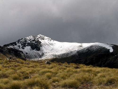 Mount Luxmore from just above the Mt. Luxmore Hut
Red Tape
Advance bookings for the huts and campsites are required. This is a very popular track, so book several months in advance. Bookings for the next coming season opens September 16 for the late October to late April season. You can book online, email, phone, mail, or fax.
To book online:
Department of Conservation
To book by mail:
Fiordland National Park Visitor Center
Department of Conservation, Lakefront Drive
PO Box 29
Te Anau
New Zealand
To book by phone:
(03)-249-7924
International ++64-3-249-7924
To book by fax:
(03)-249-7613
International ++64-3-249-7613
When To Climb
The normal booking season is from late October through late April. Travel outside this time period requires special skills, equipment, and planning. The very best season weather-wise is from December through March. The track is very crowded in December and January , and sometimes February as well. Fiordlands National Park is very wet. Expect wet, windy, and cold weather at any time of year. It can snow at any time of year, so go well prepared. We had significant snow over Christmas 2002, which is in summer time. Note also that the track can be closed during adverse weather conditions, even in summer, as it was just after our visit.
 Near the Mt. Luxmore Hut. Black Cone is the peak on the right, Mt. Owen the one on the left.
Huts and Camping
Current information as of December 2013:
Huts
Between late October and late April, three huts on the track are maintained with heating, cooking stoves (you must bring your own cooking utensils and food), mattresses (you must bring your own sleeping bag), running water, and flush toilets. There is a national park warden at the huts during the booking season. You are expected keep the huts clean and carry out all trash.
Hut fees during the booking season are as follows (prices are in New Zealand dollars):
Hut fees during the summer season (late October through April) are as follows (prices are in New Zealand dollars):
Adult (18 years and over): $54 per night
Youth (5 to 17 years): Free
Child (5 years and under): Free
Hut fees during the winter season (May to late October) are as follows (prices are in New Zealand dollars):
Adult (18 years and over): $15 per night
Youth (5 to 17 years): Free
Child (5 years and under): Free
A 10% discount is available to members, staff and instructors of the following organisations, who also hold a valid 12 months Backcountry Hut Pass: NZ Mountain Safety Council; NZ Federated Mountain Clubs; NZ Deer Stalkers Association; NZ Land Search and Rescue (LandSAR); Scouts New Zealand; GirlGuiding NZ.
Camping
Camping along the Kepler Track is allowed only at the designated locations at Brod Bay and next to the Iris Burn Hut. No camping is allowed at any other locations including near the Mt. Luxmore Hut. Campers need to take their own stoves (no fires are allowed). Since camping is not allowed near the Mt. Luxmore Hut, the second day of the tramp is a long one as you must make it all the way from Brod Bay to Iris Burn in one day.
Camping fees for the summer season are as follows:
Adult: $18 per night
Youth: Free
Child: Free
Camping fees for the winter season are as follows:
Adult: $5 per night
Youth: Free
Child: Free
 Mt. Owen and South Fiord from the Mt. Luxmore Hut.
Mountain Conditions and Links
The Department of Conservation has information on tracks and booking.
For the latest weather forecast, contact the Fiordlands Visitor Center by phone at (03)-249-7924 or International ++64-3-249-7924.
There are no weather links or mountain cams at this time, so the weather forecast must be asked for by phone or in person at the visitor center. There are weather links to Queenstown, but this is a ways away and has a much drier climate and usually different weather, thus they aren't included on this page.
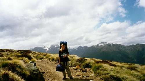
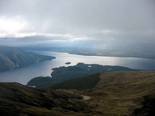 View of Lake Te Anau from Luxmore summit.