
|
|
Mountain/Rock |
|---|---|
|
|
39.55610°N / 105.6061°W |
|
|
Park |
|
|
13575 ft / 4138 m |
|
|
Rosalie Peak Overview
Rosalie Peak
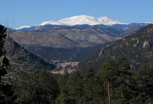
Rosalie Peak, the 207th highest peak in Colorado, is the southernmost thirteener in the Mount Evans Wilderness. When viewed from Denver, it's the rounded summit on the left end of the Evans Massif. It is named for Rosalie Bierstadt, wife of the famous painter of Western landscapes, Alfred Bierstadt. Originally, Mount Evans was named Mount Rosalie, but when the Colorado legislature renamed that summit for the second territorial governor of Colorado, John Evans, they gave Rosalie Peak its current name.
Rosalie Peak is a convenient destination for Denver-area residents. You can get to the Deer Creek Trailhead in around an hour from many parts of town. On a clear day, your views from the summit will reach far and wide. It's satisfying to see the Crestones – 110 miles away! – from your perch above Denver. Views of Pikes Peak, the Lost Creek Wilderness, and of the rest of the Evans Group are superb.
Rosalie has two sub-peaks, which add to its stature: Bandit Peak (12,444') and the highpoint of Pegmatite Points (12,227'). A hike of Rosalie can be planned to include either or both of these unranked twelvers. You can also add Epaulet Mountain (13,530') to your summit bid for Rosalie. Rosalie has a pretty, east-facing cirque, which holds the Roosevelt Lakes.
Mount Evans Wilderness
The Mount Evans Wilderness has many distinguishing features, including its flora and geology. It is one of the few places south of the Arctic Circle where arctic tundra can be found. Arctic tundra differs from more typical alpine tundra, according to Mark Pearson, "by virtue of its moisture, as it contains countless small pools of water." My group encountered some of these interesting pools during our climb of Rosalie. The Evans Wilderness is also home to some of Colorado's oldest residents, the bristlecone pine. These gnarled trees can live to be over 2000 years old!
The rock of the Evans Massif and of Rosalie Peak is from the Mount Evans Batholith, which emerged about 1.4 billion years ago. According to Hopkins and Hopkins, "This igneous intrusion cooled slowly to form a variety of granitic rocks, most predominantly the rock type called granodiorite (a granitic rock darker than granite and intermediate between granite and diorite)." Rocks on Rosalie can be crosscut by intrusions of quartz and pegmatite, the latter of which obviously led to the naming of Pegmatite Points. Pegmatite, a coarse-grained granite, is sometimes rich in rare elements such as uranium, tungsten, and tantalum.
Pegmatite Points Overview

Pegmatite Points
Pegmatite Points are really a lengthy extension of Rosalie Peak's east ridge. The Pegmatites' highpoint is at 12,227', and this summit can be readily added to a hike of Rosalie Peak from the Deer Creek Trailhead. From their highpoint, the Pegmatites descend gradually to the east, reaching a terminus at Rosedale Peak (11,825'), a popular Denver-area hike in its own right. The Pegmatite Points have no ranked summits.
To climb the 12,227' highpoint, follow the East Ridge route. When the Tanglewood Trail reaches the saddle, head east. There are a number of scrambling opportunities (opportunities that frankly don't exist on rounded Rosalie's standard routes) on these rocks, especially on the summits preceding the true highpoint. Take the time to check out the rocks while you're there. Pegmatite veins can contain feldspar crystals, giving an overall pink appearance to the area. Also, the ground is littered with quartz in spots.
Getting There
Deer Creek Trailhead: To approach Rosalie Peak from the south, please refer to the East Ridge route.
Mount Evans Road: Hiking Rosalie Peak from the Evans Road is a less strenuous way to enjoy this fine summit. To get there, exit I-70 at Idaho Springs and take Colorado State Highway 103. After 13.5 miles, you'll reach the Mount Evans Road. The road is seasonal, so unless it's summer, check ahead to make sure it's open. The toll is $6. Past Summit Lake, park at the saddle, before the road begins to switchback up to the summit of Evans. Hike south, over or skirting the summits of Epaulet Mountain and "Epaulie" en route to Rosalie Peak's summit.
Rosalie Trail: A lengthy approach to Rosalie is available via the Rosalie Trail. From Guanella Pass, hike the Rosalie Trail down-valley to its intersection with the Abyss Lake Trail. Continue on the Rosalie Trail to the saddle between Kataka and Tahana Mountains. Climb Epaulet Mountain's southwest ridge to its summit, and then hike southeast to Rosalie's summit. The Rosalie Trail can be approached from the Burning Bear Campground, as well. Hike the Abyss Lake Trail to the aforementioned junction with the Rosalie Trail where you join the route. To access Guanella Pass or the Burning Bear Campground, use the Guanella Pass Road, which connects I-70 and US-285 between the towns of Georgetown and Grant. Burning Bear is a bit over five miles from Grant.
Red Tape
Rosalie Peak is located in the Mount Evans Wilderness, and typical wilderness restrictions apply. Contacting the managing agencies (see 'Mountain Conditions') is the surest way to get up-to-date information.
Leave No Trace suggests you observe these principles when traveling and camping in all public lands, especially wilderness:
1. Plan Ahead and Prepare
2. Travel and Camp on Durable Surfaces
3. Dispose of Waste Properly
4. Leave What You Find
5. Minimize Campfire Impacts
6. Respect Wildlife
7. Be Considerate of Other Visitors
When To Climb
Rosalie Peak can be climbed year-round. Access is good, even in the winter, and the area is heavily used so you might get lucky and not have to break trail. Most of the slopes in the vicinity are low-angle. Keep avalanche safety in mind, and you can have a great winter outing on Rosalie.
Camping
Camping is permitted in the Mount Evans Wilderness. Remember, you find a camping spot, you don't make one. Help sustain water purity by camping away from creeks and lakes.
Mountain Conditions
Forest Service ranger districts are your best bet for gathering information on current snow conditions and other information. The South Platte Ranger District (303-275-5610) is responsible for the Deer Creek Trailhead. They share management responsibilities of the Mount Evans Wilderness with the Clear Creek Ranger District (303-567-3000), who could be useful for approaches from Guanella Pass or the Mount Evans Road.
For weather information, the National Weather Service is a good place to start:
Rosalie Peak experimental point forecast
Sources
Halka Chronic and Felicie Williams, Roadside Geology of Colorado, Second Edition
John Fielder and Mark Pearson, The Complete Guide to Colorado's Wilderness Areas
Ralph Lee Hopkins and Lindy Birkel Hopkins, Hiking Colorado's Geology
Dave Muller, Colorado Summit Hikes for Everyone
Gerry Roach, Colorado's Thirteeners: 13,800 to 13,999 Feet