

|
|
Mountain/Rock |
|---|---|
|
|
40.61320°N / 75.9117°W |
|
|
1615 ft / 492 m |
|
|
Overview
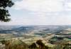
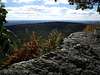
The Pinnacle is about as spectacular as it gets in a state not known for dramatic mountain peaks. Rising a thousand feet above the surrounding farmland, the Pinnacle is a tight kink in the hundred-mile-long ridge of Blue Mountain on the southern margin of the Alleganies. The dramatic bare rocks and cliffs provide incredible views to the north, east and south out over the farmlands of Berks and Lehigh County. Turkey Vultures soar in the thermals and rat snakes bask on the sun-warmed rocks.
It's close proximity to population centers (Philadelphia, Harrisburg) and moderate approach on good trail makes the Pinnacle a popular destination for dayhikers and school groups. The famous Appalachian Trail passes the Pinnacle as well so thru-hikers are common in season (June-July).
A small fissure cave on the summit (unfortunately but not unexpectely marred with graffitti) provides half an hour of 3rd and 4th-class exploratory fun. There is a wet, dangerous vertical entrance which could easily result in a 20' fall. A safer but less obvious horizontal entrance lies on the south side of the bluffs a bit below the top. Both entrances lead to a tall fissure and a short side passage. Bats, spiders, and other biota typical of much larger caves call this place home.
 |
 |
 |
 |
 |
Getting There
The Pinnacle is most easily accessed from Eckville on Eckville Road. From I78, take PA143 north (exit 35) from Lenhartsville and wind along the western bank of the Maiden Creek. After 4 miles, turn left onto Hawk Mountain Road. The Appalachian Trail crosses the road in about 4.8 miles. There is a small parking area.
"Pennsylvania," the saying goes amongst thru-hikers, "is where boots go to die." Typical Pennsylvania AT is largely level but covered with jagged rocks of all sizes. These rocks will eat your boots, break your ankles, and make you gladly trade the long-milage days on level ground for the steep climbs and descents encountered farther north or south.
Fortunately, the first few miles of the AT up to the Pinnacle are nicely mellow. Follow an old fire road as it slabs up the mountain to the broad, forested plateau. From here, the old AT continues straight (south) and cuts off about 5 miles of trails while the Pinnacle side trail (the current AT, sadly, more typical of PA trails) continues to the east along the ridgeline. A mile or two of trail will bring you to a huge cairn in the woods beyond which are the spectacular bluffs.
Total distance from Eckville Road TH is 5.3 miles and about 1000 vertical feet of climb.
 |
 |
 |
 |
 |
Red Tape
No red tape. Hunting season in the autumn may make it prudent to wear safety orange.
 |
 |
 |
 |
 |
When To Climb
Any time of year is fine though the Pennsylvania mountains are swelteringly hot in the summer and water can be scarse.
 |
 |
 |
 |
 |
Camping
Camping is permitted along the AT except within 1/4 mile of existing campsites, shelters and road crossings. There are no established campsites in the area of the Pinnacle itself and the region immediately south of the Pinnacle is closed to camping (watershed area). There are two trail shelters five miles 'north' and four miles 'south' on the AT for long-distance hikers. The Eckville Shelter is an old tool-shed in the back yard of local hiking personality Lazee and features showers and flush toilets as well as snacks and icecream for a donation. Tent sites are located across the road in a nice meadow. The Windsor Furnace Shelter south of the Pinnacle is a more typical trail shelter and will sleep a dozen or so if packed closely. Several tentsites are located here as well and there is the standard pit privey. Rocky ground elsewhere may make finding a level campsite challenging.
Mountain Conditions
