
|
|
Mountain/Rock |
|---|---|
|
|
43.79870°N / 114.1515°W |
|
|
11865 ft / 3616 m |
|
|
Overview
This peak, 5th highest in the Pioneer Range is one that should attract more attention than it does. It looks dissimilar when viewed from different sides. From the North it is pyramidal shaped, from the East it looks rather blocky.
There is some confusion as to which mountain is the Bedstead. Originally the peak with that name is a little to the West and has a lower elevation. It is shown on most maps as being the true Devil's Bedstead. Most now refer to them as the Devil's Bedstead EAST and WEST.
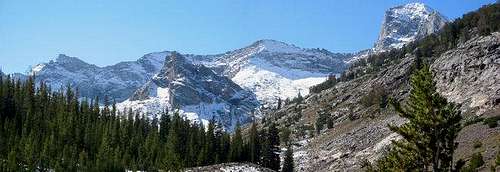 Photo by kdonaldson
**Note: After seeing this peak again from afar, I can't help but think that this is the peak that was originally meant to be called the Devils Bedstead. It looks too much like the head of a bed with ridges forming the bed. I think map makers got confused and made a mistake......just my opinion.
Climbing from the Boulder Lake trail or Kane Creek will not disappoint one. It doesn't get any better than this in Idaho.
The traffic on this one is very light as most folks are headed for the Hyndman,Old Hyndman, Cobb area.
This peak is generally climbed July/August using the North face route(Class 3) which can be approached from both Kane Creek or Boulder Lake trails. (The Kane Creek approach looks like it could be a bushwack). Other routes on this mountain appear to be technical.
**Note: Had another close look at this peak from Near Phi Kappa Peak on July 31, 2004.....just spectacular!
Getting There
From Mackay Idaho (89 miles Northwest of Idaho Falls), drive North on 93 to the Trail Creek Road (+-15.5 miles), then Southeast to the Copper Basin Road turnoff (18.5 miles) then South to the Wildhorse road (2.1 miles) then following Wildhorse Creek (5.6 miles ) to Boulder Creek.
From Sun Valley drive over the Summit Creek Road to the Copper Basin turnoff (+-19.5 miles) and follow directions given above.
Kane Creek approach turn off is just 3.8 miles further up the Trail Creek road coming from Mackay.
Red Tape
No Permits or Fees. Much of the Trail Creek road is closed during winter months.
When To Climb
July / August / September are the best times to climb. This would be a difficult peak to climb for most people out of season. Hard to get to and all of the obvious difficulties associated with Snow climbs.
Camping
There are several campgrounds in the area, Phi Kappa, Park Creek and Wildhorse. Or there are any number of unimproved areas to rough it.
Mountain Conditions
Ketchum Ranger District
P.O. Box 2356
Ketchum, Idaho 83340 -----Phone (208) 622-5371----Fax (208) 622-3923
Lost River Ranger District
P.O. Box 507
Mackay, Idaho 83251----Phone (208) 588-3400----Fax (208) 588-2924
I called these folks on 6/29/04 Very Nice & Very Helpfull
There are some web cams in the Sun Valley area that are used mainly for skiing conditions.