
|
|
Mountain/Rock |
|---|---|
|
|
47.79200°N / 121.613°W |
|
|
5464 ft / 1665 m |
|
|
Overview
Special Note: The Proctor Creek gate at Hwy 2 can sometimes be locked with little or no notice. They (logging company) have closed it before due to garbage dumping.Mt. Persis is Mt. Index's little sister. One might say Persis is Index's stunted twin, for the two peaks share a lot of "facial features." Both are steep walled on the north and east sides and both are rugged but relenting on their south and west sides. This is understandable, as both peaks are part of a granodiorite intrusion emplaced in the early Tertiary Period (50-60 million years ago).
Mt. Index has garnered all the fame. This is expected given the ominous appearance of its three distinct summits, not to mention the pristine Lake Serene at its northeastern base. Persis has no lake attributable to it. However, what you don't get from Index or Lake Serene is a view of Index's stunning west side. The east and northeast sides of Index may cradle the lake and the views of the towers from below, but it is Mt. Persis that offers up the views of Index's west side from a high position. As such, you don't or won't get dizzy with tilted head gazing up at shear walls. This requires, of course, that the weather be clear so you can actually have a view. This is western Washington; you takes your chances. Ergo, if you have a choice, don't climb this peak on a bad weather day as you'll be missing out on the peak's main allure.
The nice thing about Mt. Persis is the existence of an easy trail to the top, though I must admit I have not been on this trail (I bushwhacked my way to the top). The effort-to-view ratio tops the charts--at least in so far as nearby Mt. Index is concerned. Also, Persis along with Index can be seen on the Cascade front from the greater Seattle area.
Persis was the name of Amos Gunn's wife. They settled the valley in 1890.
 |  |  |  |
Getting There
Mt. Persis is located in the Skykomish River valley at about the point where the North and South forks join. The peak is located roughly two miles northwest of Mt. Index and three miles WSW of the town of Index. U.S. Highway 2 runs past the north side of the peak. This highway is your approach road from afar.To get to Mt. Persis from the Puget Sound, take US-2 (Stevens Pass Highway) east from Everett. There is a shortcut route via SR-522 from the Greater-Seattle area that goes through Woodinville and meets US-2 at Monroe. Suggest you consult with your maps. From Monroe, drive east roughly 13 miles on US-2. A turn-off from the highway takes you via a logging road to the trailhead. The turn-off is about 0.6 miles beyond where the four-lane road necks down to two-lanes From the east (from Leavenworth), drive US-2 over Stevens Pass and continue approximately another 24 miles to milepost 33. The turn-off is just east of this milepost.
The logging road has been gated in the past right off the highway (gated due to vandalism and illegal trash dumping), but currently (in the last couple of years) this road has been open. This road goes by various names: No Name Creek Road, Proctor Creek Road, Cavanaugh Lake Road, and Forest Road 62 (FR-62).
Drive FR-62 3.4 miles to a junction (1,623 ft) and go left. In another mile reach another junction (2,380 ft). Go left again and continue to roads end in another 0.7 miles or so. This is the trailhead for Mt. Persis (c. 2,800 ft). This is not a wide parking area. More like a wide stretch at road's end. Find the trail somewhere on the uphill side of the road. It might lead back to the north.
 |
West Ridge Trail
The trail gains the West Ridge and follows it eastward to Pt. 5017 (NW Persis). A short 100-ft descent then climb up takes you past a few ponds just before the summit. The summit area is flat from this approach. The trail is steep at first but benign later. Distance = ~2 miles. Elevation gain = 2,700 ft. Time = 2-3 hours depending on fitness level.A climb from the southwest from the head of Proctor Creek is to be avoided at all costs. This is the route I took. The brush was thicker than the bristles of a paint brush. I was lucky to make it out alive.
 |  |  |  |
Red Tape
Possibly that blasted Trail Park Pass but I'm not sure on this. Besides, maybe it'll be going away soon (fingers crossed).As mentioned before, FR-62 is gated at times way down by the highway. The timber company active up the road doesn't take kindly to vandalism and illegal dumping. And why should they?
 |
When To Climb
This mountain can be climbed year-round. In the summer it is a peace of cake (see West Ridge Route above). This is also a popular winter snowshoe. The difficulty will be getting to the trailhead (2,800 ft) or sufficiently close to it that you don't have to traipse many extra miles of logging road, which isn't always exciting. Furthermore, the road may be gated way down by the highway. In this case, a bike might be nice to have.Camping
There is not much need for camping on this mountain as it is a day-climb. However, if doing a two-day traverse to Mt. Index, a camp along the way will be required. Just where you camp would depend on how far you got or cared to get on the first day. The traverse can be done in a long day with a very early start. The peak resides in the Mt. Baker-Snoqualmie National Forest.Mountain Conditions
Localized ForecastIndex town forecast
 |
Proctor Creek, Head of
 |  |  |  |  |
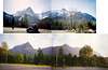
Views from the Mountain, Part I
 |  |  |
Views from the Mountain, Part II
 |  |  |  |  |
kati8293 - Sep 29, 2005 6:36 pm - Hasn't voted
Untitled CommentWe were up there yesterday (9/27) and it is still gone...grrr...
Bicyclebob - Aug 21, 2005 10:58 am - Hasn't voted
Untitled CommentSome worthless dirtbag has misplaced or stolen the register. Searched the area and couldn't find it.
kati8293 - Sep 29, 2005 6:36 pm - Hasn't voted
Untitled CommentWe were up there yesterday (9/27) and it is still gone...grrr...
Redwic - Jul 15, 2009 4:02 am - Hasn't voted
As of July 13, 2009...... the gate near Highway 2 will be closed and locked, except during times the road is needed for logging use. Also, it is illegal to park in front of the gate, if closed.
bigjoesmith - Jul 24, 2010 10:17 pm - Hasn't voted
Gate Now OpenOn 7/23/2010 the logging company (Longview?)that controls access to the road up Proctor Creek has unlocked the gate. We talked to the person who was unlocking the gate and he said it had been locked (for general access) for over a year, but they were now unlocking it on a trail basis. It is now possible to drive to the high point of the logging road for the start of the west ridge climbers tail.