

-
 11850 Hits
-
 87.7% Score
-
 25 Votes
|
|
Mountain/Rock |
|---|---|
|
|
45.79750°N / 7.01900°E |
|
|
9609 ft / 2929 m |
|
|
Overview
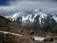
Testa di Liconi (2.929m) is, with Mont Crammont (2.737m), one of the most important panoramic summit for Italian side of Mont Blanc. Located at the end of a lonely valley, Testa di Liconi lies dominating Liconi Lake, a blue pearl in a green-grass plateau, and the omonimous pass. Testa di Liconi is not such a beautiful mountain, but it becomes very interesting joining together these three significant elemens: lake, pass and summit. 200 meters higher than Mont Crammont, from Testa di Liconi is visible the Mont Maudit (4.468m), Mont Blan du Tacul ridge (4.248m) and Aiguille du Midì (3.842m). Great sightseen on most of Valle d'Aosta main summits. A great experience to live here is the sunrise on SE face of Mont Blanc.
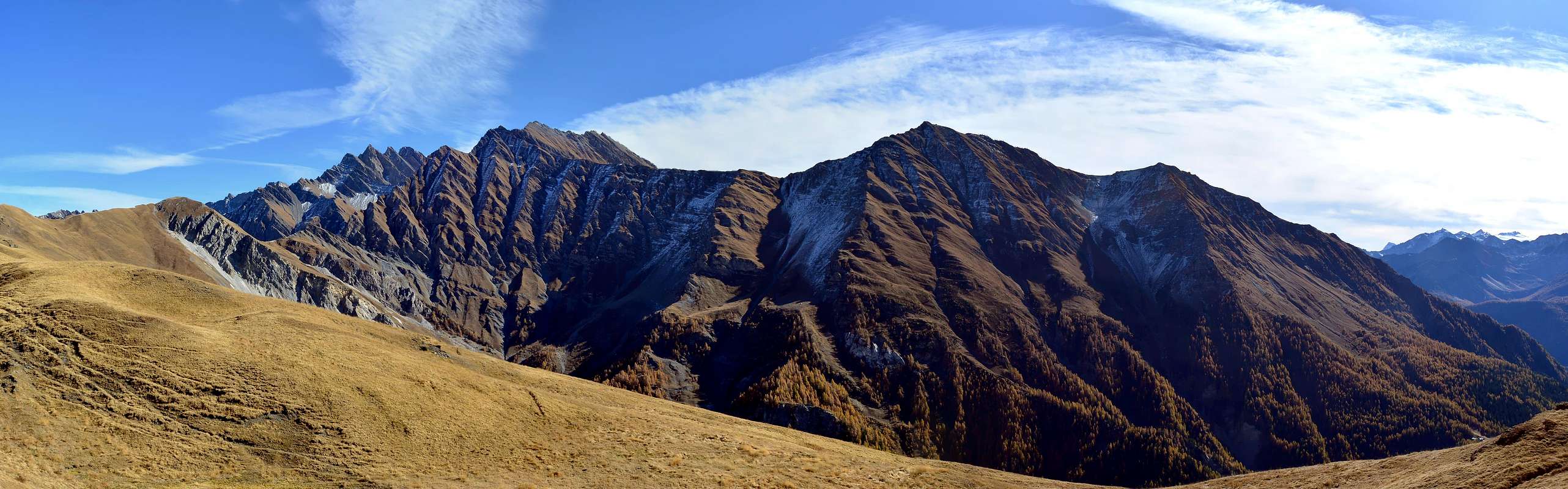
Testa di Liconi (2.929 m) è, con il Mont Crammont (2.737 m), una delle vette panoramiche più importanti nella parte italiana del Monte Bianco. Situata alla fine di una valle solitaria, Testa di Liconi si trova a dominare il Lago Liconi (2.595 m), una perla blu in un altopiano di erba verde, e il colle omonimo. Testa di Liconi non è una montagna così bella, ma diventa molto interessante unire insieme questi tre elemeni significativi: lago, passo e vetta. 200 metri più alto del Mont Crammont, da Testa di Liconi è visibile il Mont Maudit (4.468 m), la Cresta del Mont Blanc du Tacul (4.248 m) e l’Aiguille du Midì (3.842 m). Inoltre si ha una spettacolare veduta sulla maggior parte delle vette principali della Valle d'Aosta. Un'ottima esperienza da vivere qui è l'alba sulla parete SE del Monte Bianco.
Getting There
Morge (La Salle):- From Turin, Milan, Switzerland (Tunnel or Grand St. Bernard Pass): Motorway A5 - Courmayeur direction, Morgex exit. Turn right to La Salle. Follow Planaval direction. Before arriving at Planaval, where paved road ends, once passed Morge village, a car park close to a wooden spring signs the headtrail. Yellow panels help for Liconi Valley direction.
- From Seez, Bourg St. Maurice, Petit St. Bernard Pass (France). Drive through La Thuile to Pre Saint Didier, turn right to La Salle on SS.26, until La Salle. Turn lefto for Morge (Planaval).
- From Chamonix/Geneve (Mont Blanc Tunnel) Drive through Courmayeur on SS.26 road, until La Salle. Turn left for Morge (Planaval). Villair, Courmayeur (Val Sapin Route)
- From Turin, Milan, Switzerland (Tunnel or Grand St. Bernard Pass): Motorway A5, Courmayeur exit. Enter in Courmayeur downtown. Follow La Saxe, then turn right to Villair (Val Sapin) direction.
- From Seez, Bourg St. Maurice, Petit St. Bernard Pass (France). Drive through La Thuile to Pre Saint Didier. Turn left for Courmayeur on SS.26d road. Enter in Courmayeur downtown. Follow La Saxe, then turn right to Villair (Val Sapin) direction.
- From Chamonix/Geneve (Mont Blanc Tunnel) Once arrived in Courmayeur, turn left, downtown. Follow La Saxe, then turn right to Villair (Val Sapin) direction.
Route
From the village of Morge (1.629m) follow the path n° 21 towards the North-west until you reach the Alpe Piginières where, leaving on the right the path n° 20 towards Planaval little Hamlet, continue towards the West and, after having crossed a very small stream and you after again having crossed the Torrent de Chambave, it reaches the Alpe Villottes first and then that of Liconi (1.878m; 1h'15/ 1h'30) near the "Madonna de Lourdes", where even the path n° 4 arrives (from Morgex Municipality). With this last continue on the valley floor next to Torrent Liconi reaching, after passing a small waterfall, the homonymous lake (2.555m) located between the Testa (Head) of Liconi and the Aiguille de Chambave (3.067m). With a small arch-shaped turn to the North you get to the Arp de Liconi (2.662m) and with almost level path to the homonymous hill (2.674m; 3h'30/4h'00). From this two possible itineraries:a) - traverse to the left on the Northeast Slope and on a small track in the middle of debris and crushed rocks reach the wide saddle located between the two Summits (Western 2.929m, Eastern 2.915m). Or
b) - from the hill follow the North Ridge formed by easy but broken and sometimes insecure rocks reaching the Western Summit, the highest (for the both around 1h'00 from Colle Liconi).
 |
 |
 |
 |
 |
Dal Villaggio di Morge (1.629 m) seguire verso Nordovest il sentiero n° 21 fino a raggiungere l'Alpe Piginières dove, lasciando sulla destra il sentiero n° 20 verso il Villaggetto di Planaval, si continua verso Ovest e, dopo aver guadato un torrentucolo, si raggiunge, nonché dopo aver attraversato anche il Torrent de Chambave, l'Alpe Villottes prima e poi quella di Liconi (1.878 m; 1h'15/1h'30) presso la "Madonna de Lourdes" ove arriva anche il sentiero n° 4 (con partenza dal Comune di Morgex); con questo ultimo continuare sul fondovalle a fianco del Torrent Liconi raggiungendo, dopo aver oltrepassato una cascatella ben in vista, l'omonimo lago (2.555 m) posto tra la Testa di Liconi e l'Aiguille de Chambave (3.067 m). Con un piccolo giro a forma di arco a Nord si arriva a l'Arp de Liconi (2.662 m) e con percorso quasi pianeggiante all'omonimo colle (2.674 m; 3h'30/4h'00). Da questo due itinerari possibili:
a) - traversare verso sinistra sul Versante Nordest e su di una appena accentuata traccia in mezzo a detriti e rocce frantumate raggiungere l'ampia sella situata tra le due sommità (Occidentale 2.929 m, Orientale 2.915 m). Oppure
b) - dal colle seguire la Cresta Nord formata da rocce facili ma rotte ed a volte insicure raggiungendo la sommità Occidentale, la più alta (per entrambi all'incirca 1h'00 dal Colle Liconi).
Bivacco Luigi Pascal
Since June 2006, a new bivuoac was built on the summit of Testa di Liconi. The right term to define "Bivacco Luigi Pascal" is "apartment". This very confortable building can host up to 8 person (in huge bed-spaces). It's possible to cook (gas available) and, in July and August, when ice is not a problem, there is an internal toilet. A small solar cell panel give enough energy for lamps. Dining room with confortable seat places, with a panoramic window on Mont Blanc's Breva side. Probably, this is the most beautiful and confortable bivouac in Aosta Valley.
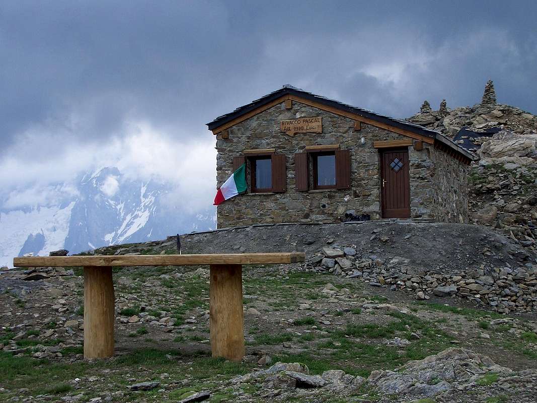
Dal giugno 2006, un nuovo bivacco è stato costruito nei pressi della Testa di Liconi. Questo edificio molto confortevole può ospitare fino a 8 persone (in comodi posti letto). È possibile cucinare (gas disponibile) e, nei mesi di Luglio e Agosto, quando il ghiaccio non è un problema, c'è un bagno interno. Un piccolo pannello solare fornisce energia sufficiente per l’illuminazione interna, una sala da pranzo con posti a sedere confortevoli, con una finestra panoramica sul lato del ghiacciaio della Brenva, Monte Bianco. Probabilmente, questo è il bivacco più bello e confortevole in Valle d'Aosta.
Difficultie
The routes is rated E.
L'itinerario è da classificarsi in E.
Gear
Hiking gear.
Da escursionismo.
Image by Buxlex
 |
 |
 |
 |
 |
 |
 |
 |
 |
 |
 |
 |
 |
 |
 |
Campings
Remember that free camping is forbidden (except for emergency reasons, over 2.500m, from darkness until dawn).
Mountain Conditions
- You can get meteo information at the official site of the Regione Valle d'Aosta:
- Valle d'Aosta Meteo
Webcam
- WEBCAM on Aosta Valley:
- Webcam
Books and Maps
BOOKS:
- "Guida dei Monti d'Italia-Alpi Pennine" (Vol. I°) di Gino Buscaini-Club Alpino Italiano/Turing Club Italiano, Luglio 1971 (in Italian).
- "Diari Alpinistici" di Osvaldo Cardellina e Indice Generale accompagnato da Schedario Relazioni Ascensioni 1964-2014 (inediti).
- "Rifugi e Bivacchi della Valle d'Aosta - Massimo Martini e Luca Zavatta, Editrek e l'Escursionista Editore.
 |
 |
 |
MAPS:
- Kompass "Massiccio del Monte Bianco Valle d'Aosta Sentieri e Rifugi" Carta turistica 1:50.000.
- I.G.C. Istituto Geografico Centrale Torino "Massiccio del Monte Bianco" (carta n° 4), Torino, 1998 1:50.000.
- I.G.C. Istituto Geografico Centrale Torino "Monte Bianco-Courmayeur-Chamonix M.B.-La Thuile" (carta n° 107), Torino 1989 1:25.000.
- I.G.M. Istituto Geografico Militare "Gr. Rochère" 1:25.000.
- L'Escursionista "Monte Bianco Courmayeur" Edizioni Rimini 2004 1:25.000.
- Edizioni Tabacco "Mont Blanc" Udine, 1978 1:50.000.
- Studio F.M.B. Bologna 1988 "Monte Bianco-Mont Blanc" 1:50.000.
- Carta Comunità Montana "Valdigne e Mont Blanc Les Sentiers", 2001 1:50.000.
Important Information
- REGIONE AUTONOMA VALLE D'AOSTA the official site.
- FONDAZIONE MONTAGNA SICURA Villa Cameron, località Villard de la Palud n° 1 Courmayeur (AO) Tel: 39 0165 897602 - Fax: 39 0165 897647.
- A.I.NE.VA. (Associazione Interregionale Neve e Valanghe).
Useful Numbers
- Protezione Civile Valdostana località Aeroporto n° 7/A Saint Christophe (Ao) Tel. 0165-238222.
- Bollettino Meteo (weather info) Tel. 0165-44113.
- Unità Operativa di Soccorso Sanitario Tel. 118.