

|
|
Mountain/Rock |
|---|---|
|
|
39.38216°N / 120.36417°W |
|
|
Nevada |
|
|
Hiking |
|
|
Spring, Summer, Fall, Winter |
|
|
9017 ft / 2748 m |
|
|
Overview
Basin Peak is located just north of Interstate 80 in the northern portion of the Sierra Nevada range and in close proximity to Lake Tahoe and Truckee. A ridge connects it to Castle Peak 9,103' forming a bowl know as Round Valley. While this area is very popular, Basin Peak sees a lot less traffic than Castle Peak. In the winter this whole area is very popular with skiers and boarders because of the relatively flat, easy approach and the gentle wide open bowl of Round Valley.The mountain can be reached in a couple hours from either the ridge between it and Castle Peak or from the Pacific Crest Trail (PCT).
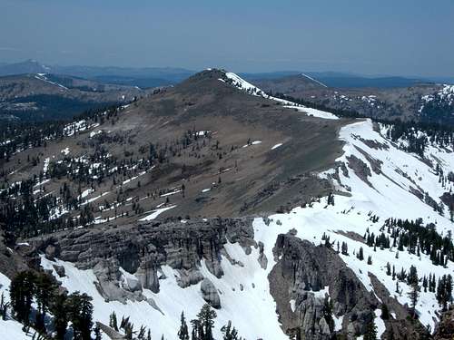
Basin Peak in May 2007 from Castle Peak
 |  |  |  |
Getting There
Take Interstate 80 to the Castle Peak/Boreal Ridge exit. In the winter some people may park at either the Sno-Park or the Boreal Ridge parking lot. Both are on the south side of the freeway. Otherwise everyone just parks on the road to the north of the freeway exit where it is paved, free and often crowded.For information on Sno-Park fees and permits:
The most popular route starts at the road just north of I-80 at the Castle Peak/Boreal Ridge exit. The road is paved for an eighth of a mile or so up to the gate where it turns into a dirt road and heads north. There are guidebooks and information out there suggesting starting south of I-80 at the PCT trailhead. The PCT goes under a bridge often flooded with water, and is very hard to follow. It is also way longer. For day-hikes, the road north of I-80 is recommended.The road terminates after about one and a quarter miles. A trail continues north to Castle Pass at 7,938'.
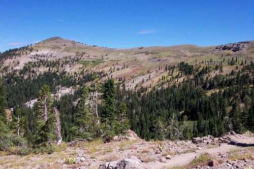
Basin Peak from near Castle Pass
From Castle Pass there are two options. If just hiking Basin Peak, head down the PCT until you reach Round Valley at about 7,850'. You can go straight up to the summit from the valley, or continue up the trail a little further to gain elevation. Generally, this approach has a distance of between 4 miles to 4 1/2 miles one way, gaining about 1,800'.
The second option is to head up towards Castle Peak. Before getting up to the ridge between Basin Peak and Castle Peak, head north towards Basin Peak and descend to the saddle. There are a few ups and downs, and the true saddle is actually about 3/4 miles from Basin Peak. The total distance via this route is a little under 4 miles one way, gaining a little under 1,900'. If combining Basin Peak and Castle Peak, the total round trip distance is about 8 1/4 miles. If combining Basin Peak with Castle Peak, many often do the trifecta, and include Andesite Peak 8,219'. This can be done as a loop, by hiking up Castle Peak first, then Basin Peak, then down to the PCT to Round Valley back to Castle Pass. Then heading up to Andesite Peak, dropping down to the Hold in the Ground Trail and back to the trailhead. I did this on May 24, 2015. It was only about 9 miles total, gaining less than 3,000'.
Red Tape
There is no red tape. The road is managed by the U.S. Forest Service. People often park on the paved part of the road in busy summer weekends.When To Climb
Basin Peak is an ideal snowshoe destination. Certainly summer and fall are easier times to hike here, but this is really a year-round destination.
Typical Sierra winter weather patterns are encountered here and the summers are usually mild to warm.
Camping
This is such a short endeavor that camping is just not necessary except perhaps in the winter when you may like to make a weekend out of it skiing. In that case the famous Peter Grubb Hut is an excellent option. For a nominal fee you and several others can stay in this rustic hut, which is right smack in the middle of Round Valley. Its location facilitates making laps from Castle Peak to the east, Basin Peak to the north and everywhere in between. The hut is available through reservations.Mountain Conditions
By virtue of its location and orientation, the Sierra Nevada mountain range is the first area that receives significant precipitation in the form of snow. Many tales of people at odds with extraordinary winter weather originate from the area of Donner Pass including the famous Donner party. Weather data has been gathered here for over 130 years and can be accessed online. Please take a look at weather historian Mark McLaughlins home page:
Considering how much snow this area receives it should come as no surprise that the ridge between Castle and Basin Peak and a portion of the north ridge of Basin Peak usually become corniced in the winter. So, here is a link to the local avalanche report:
Local weather report: