

-
 33656 Hits
-
 91.13% Score
-
 34 Votes
|
|
Mountain/Rock |
|---|---|
|
|
45.28654°N / 14.20240°E |
|
|
Hiking, Sport Climbing |
|
|
Spring, Summer, Fall, Winter |
|
|
4573 ft / 1394 m |
|
|
What's New On This Page?
 Branko - Vojak summit
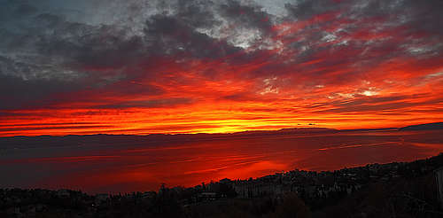
> Jan 24th, 2019: Design corrections.
> Dec 31st, 2018: Geological overview added.
> Jun 1st, 2016: Ripenda and Skitača chapter added.
> Oct 28th, 2009: Lovran chestnuts chapter added.
> Sep 15th, 2009: Routes Overview chapter added.
> Jun 10th, 2009: The Suhi Vrh chapter added.
> Sep 26th, 2008: A few pictures embedded.
> Sep 26th, 2005: The Sisol chapter added.
Overview
The name is pronounced Uchka, and written Učka. It is of a Croatian origin and supposedly comes from 'Vučka', meaning 'Wolf's mountain'. It is said that Istrian people were naming it Caldiera. The Dinarides, stretching across Balkan peninsula, are not very high on their NW end. Where Eastern Alps finish and Balkan begins, landscape is hilly, but still some summits deserve to be called mountains, especially because they often rise from planes with low altitude or even from the sea level. Istria peninsula, the biggest one in Adriatic, is separated from the continent with one such streak of mountains, stretching in a NW-SE direction, and when reaching Kvarner bay, continuing along the whole eastern Istria towards the south. The highest summit of these mountains is Učka, the landmark of Kvarner bay.
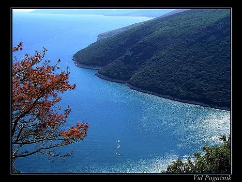 Plomin Bay
Učka can be best considered as a massif, although the most remarkable part is only its highest part. The mountain range is running along the Kvarner bay in a north-south direction. On the north, the massif of Učka starts on Poklon saddle, 922 m.
A few kilometers towards the south the highest summit already stands. Its name is Vojak, 1394 m. Then the range continues over Suhi vrh (Dry Peak), 1332 m (where the core part of Učka ends) to Perun, 881 m, Brgud, 907 m, Kremenjak, 827 m, Sikovac, 780 m, Sisol, 835 m, Bukovo, 711 m to Vrlič, 607 m, after which the range ends in Plomin bay.
 Branko - Vojak summit
 Hiking the south ridge
The eastern slopes of Učka, facing towards Kvarner bay, are covered with dense forests. Although Kvarner is very sunny, this part of the mountain gets a lot of rain, understandable for a 1400 m high barrier rising just from the sea. The eastern part is dry and grassy, but its slopes are also high - 1000 meters to the plane of Boljunsko polje.
On Kvarner coast, below Učka, famous tourist resorts are situated. The riviera begins after the big city of Rijeka. First the famous Opatija comes with its many luxurous hotels. Then Ičiči, with a nice marina, Lovran and Mošćenička draga. On the inner side of Učka, just below its summit, there are two small villages: Vela (Big) Učka, 920 m and Mala (Small) Učka, 1000 m.
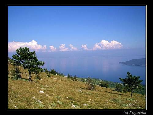
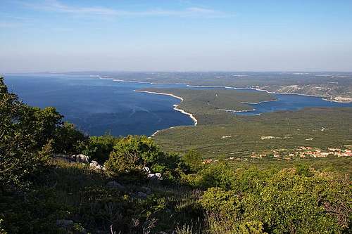
Down on Boljunsko polje there are several more or less abandoned villages. The summit of Učka is interesting first of all because of grandiose panorama. Its most beautiful part is of course Kvarner bay with its many islands. The panorama of Kvarner bay (area around Rijeka) includes, besides sea and coastal towns with harbours, also the magnificient mountain background with Obruč, Snježnik, Risnjak and later coastal range leading to Velebit. On the other side the whole Istria peninsula lies below our feet.
In the distance, if visibility is very good, Alps and Apenines can be seen. Secondly Učka is a nice hiking goal. Many trails reach the summit from all sides. Although the mountain looks humble it hides also one beautiful climbing region - Vranjska (or Vela) draga (canyon). And finally, the mountain can also be the objective of many other, non-mountaineering interests: cycling, paragliding, nature observing, speleology etc. In conclusion: if you are spending holidays in Istria, why not visiting on your way there or back also Učka?
Geological Overview
Being part of Outer Dinarides, Učka is also built of various limestones which were deposited in ancient Thetis sea during the Cretacious and Paleogene period, since some 145 million years ago on. The rising of Učka was caused by the Adriatic tectonic micro-plate, which before some 65 million of years started to move towards the NE. That process is still going on, but moving of the Istrian plate, which is also turning counter-clockwise) and the important Kvarner fault are causing that the massif of Učka is running in the N-S direction, and not in the typical Dinaric NW-SE direction.
The very upper ridge of Učka is made of Upper Cretacious and Paleogene rocks which are superimposed on layers of Eocene flysh and limestones. All that is resulting in a big number of caves (some 200), distinct rock walls and ravines. While the western side of mountain is mostly dry, on the eastern side on some places there are valuable water sources, while on other places fresh water is rushing from underground only on the sea level or even below it.
 |
 |
 |
 |
 |
Crags and Areas For Climbing
 Branko - Vela draga
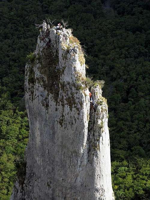 Branko - the Big tower in Vela draga
Vranjska draga (canyon) is a natural pearl. It is situated on the NW part of Učka - just below the entry of the road into the Učka tunnel (on the inland side). While once the canyon obviously had water, today it is dry - the only one thing missing for the perfect paradise. The canyon starts on the altitude of some 700 m, descending down to Boljunsko polje (plane) on 200 m.
Walls are also appropriate for climbing, but the biggest attraction are limestone towers, some of them being thin as spaghetti and really picturesque. Climbing routes (they are of various difficulties) are being only recently discovered. So to summarize: In this climbing area you will be alone, rock is fine and warm, appropriate for spring and autumn (also in winter if there's no wind), while in summer ascends could be very hot. The list of routes which are protected by bolts, and their difficulty is posted in English on this web site.
Zijavica is another area, situated on the other, coastal side of Učka. The crag is close to the small tourist town Moščenička Draga, and has some two dozens of routes, rated from 4c to 7c. The topo is here.
The Karst Edge (Kraški rob) is a limestone step, stretching from Trieste on the NW to Učka on the SE. This is the step (above it is the mountain range, forming the border of Istria), where limestone changes to flysh, which is then forming the central part of Istria. Above Trieste and in Slovenia in the Karst Edge walls there are very popular climbing regions (Glinščica, Osp, Mišja peč, Črni Kal etc.). For the Croatian part I am not familiar, if there are any popular routes - but the landscape and possibilities seem the same. The above described Vranjska draga is not a part of Karst Edge, although limestone walls look similar.
The appropriate guidebook for Istria climbing resorts is: J. Skok, E. Švab, D. Perhat: Plezališča brez meja. Sidarta, 2003. The guidebook deals with Istria and Karst edge climbing resorts in three countries: Italy, Slovenia and Croatia. The guidebook is in 4 languages: Slovenian, Italian, German and English. (See also here).
 |
 |
 |
 |
 |
Suhi Vrh
Suhi Vrh peak (1.332 mtrs) is the 2nd highest peak of Učka mountain. It is situated south of Vojak peak, where the core part of Učka ends. The peak itself is standing above the rock cliffs on the eastern slopes of the mountain. The view from this peak is great! It offers panorama view towards Kvarner bay and its islands (Krk, Cres, Lošinj,...), Rijeka city and hinterland mountains, Velebit massif and beautiful beechwood forests of Učka.
The main route to Suhi Vrh peak goes from the saddle east of Učka main summit. First marked route leads over the grassy slopes from where is nice view of Sisol peak and after some 15 min route enters into beechwood forest. Another 15 min and you will arrive to Suhi Vrh lookout point. Some 20 mtrs more and you will reach the summit. To return you can use same way, but there is also another path, which is not well marked, that continues from Suhi Vrh summit over the ridge (in north direction) and descends towards Vrata pass, where the route from Lovranska Draga is passing.
 |
 |
 |
 |
Sisol
 Kvarner bay from the ridge of Sisol
It's a mountain of its own, this Sisol, 835 m. But being with Učka a part of the same massif, it is also correct to be represented on this page. It is a beautiful hiking goal. Being more than 500 m lower than the summit of Učka, it still enables a great panorama over Kvarner bay. Or even more so, especially on a bit hazy day, when from a higher altitude hardly any detail can be seen. If we hike up from the Plomin or the panoramic point SE of this beautiful old town, paths bring us on a grassy plateau.
The marked path continues northwards all the way on the E side of the grassy ridge and when reaching the rocky fore-summit of Sisol it climbs over a few rocks up. The other usual route to Sisol is from the E, from the picturesque Brseč town. From there the marked path ascends on the main ridge N of Sisol. It gains it on the point where just on the ridge there's a beautiful natural window, called Provrtenica ('Drilled-through' would be a direct translation).
From there we follow the rocky main ridge towards the S and in less than 30 min we reach the highest point. Both these tours can be combined in a nice round tour (possibly with a bike connection). From Plomin (or the panoramic point SE of it) over Sisol to the very summit of Učka a marked path goes, representing one of the most interesting and panoramic hikes in Istria.
 |
 |
 |
 |
Ripenda and Skitača
 From Brdo above Skitača village, due south
Even further towards the south, across the bay of Plomin, the last two higher limestone massifs of Učka region are rising. The highest point of Ripenda is 474 m above sea level, the highest point of Skitača is 538 m (Goli vrh). More to the south there is the flatland towards Pula town. The summits of both plateau-like mountains are rarely visited by hikers.
The place is quite remote and only on the coast there are nice and quite popular tourist destinations (like Rabac). The biggest town in the area is the beautiful Labin. On Ripenda nice must be the hike from Rabac to Ripenda Kosi village and further on some panoramic summit. There are also a few very nice bays and coves on the coast, which can be reached only on foot (even by pathless terrain).
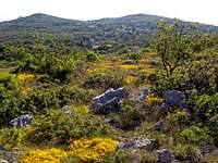
On Skitača nice and very panoramic are the hills above the village, but also crossing the whole massif (can be done also by mountain bike) is a nice challenge. Especially beautiful is spring there (May, start of June).
 Sunrise Sunrise |
 Orlić panorama Orlić panorama |
 Skitača in spring Skitača in spring |
Getting There
 The position of Učka mountain
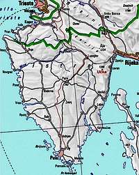
From Rijeka towards the center of Istria a modern road goes. While the old road climbs the Poklon saddle, the new one goes through the tunnel on an altitude of around 500 m. From NW, say from Trieste or Koper, Učka can be reached by a road via Buzet. And from the south, from Pula or other tourist resorts on the coast of Istra, Učka can be reached by a modern road via Pazin. From Poklon saddle a rather good road climbs to the very summit of Učka. And how to reach the old road over Učka? From Rijeka side (east): through Matulji and Veprinac, from Istra side (west) exit at the west portal of Učka tunnel from main to the local road in an upward direction.
Routes Overview
Show a bigger map
Mountain paths: Close-up the above map to see the paths!
- A marked path ascends the summit from Poklon saddle.
- Even closer to the summit starts the path from Mala Učka village.
- Many marked paths go up from Kvarner tourist resorts: they start on the sea level (Lovran, Medveja, Moščenićka draga etc.) or higher - in Lovranska draga (400 m). For any path from the sea level you will need some 3-4 hours or more to reach the summit.
- The paths from Istria inland are not marked.
- The paths along the whole southern ridge are very nice, but quite long.
Besides marked paths also many old shepherd and peasant paths climb up, but many of them are probably in a bad shape.
Lovran chestnuts
 Lovran chestnuts - Marrons
Lovran chestnuts - also called Marrons - are the expression of Lovran's uniqueness and valuable heritage of this area. The privately-owned plantations of chestnuts trees are spreading on the eastern slopes of Učka mountain, where they have been grown on orchard-like parcels for centuries. The climate and the sunny slopes of Učka from Ika to Mošćenička Draga facilitate the cultivation of marrons.
Every year in October, when chestnuts are ripe, the traditional Marron Day ('Marunada' or 'fešta od maruna')is held during weekends, starting from the 2nd weekend at October first at Lovran, than at Dobreč and finally at Liganj village. The Marrons chestnuts are famous because they are larger and tastier than the other kinds. This was obtained by selecting, improving and inoculating the common chestnut.
There are two types of Marrons, the 'Branac' and the 'Dubenac'. The 'Branac' is picked ripe, when it falls down from the tree free of its prickly bur, called 'žajica'. It spoils quickly, so it should be consumed soon after picking. The 'Dubenac' ripens later, it is gathered in heaps and covered with branches, after which it is left to mature for another month.
 |
 |
 |
Old Towns and Villages of Istra
 Chimneys of old Krsan - Ucka is behind
If you want to explore Istria, there are endless possibilities for panoramic driving or cycling. The landscape is like in Tuscany or Umbria (although less urban), towns and villages have a rich heritage and are very picturesque. As this is a mountaineering site I'll post just a few sample pictures.
 |
 |
 |
Red Tape
 Branko - A tower in Vela draga
The whole region is protected as a natural parc. If interested, here is its web page. For the tunnel of Učka you need to pay a toll, while the old road from both sides and to the summit is toll-free.
When To Climb
Učka can be climbed all year, the best time is when visibility is good. Due to its height, Učka receives a lot of precipitation. The annual average is around 3000 mm. In winter the summit receives considerable amounts of snow, which adds at that time to its attractive appearance.
Camping

Although you probably will not sleep on the mountain there's a mountain hut on Poklon saddle. It has 14 beds, and is the propriety of Opatija Mountaineering Club. For information call Mrs. Marica Tomaško, tel. (051) 712-785. Camping is possible at Medveja & Icici camp resort by the sea.
Mountain Conditions
For weather see Croatia at WeatherOnline or Croatian Meteorological and Hydrological service.