
-
 29928 Hits
-
 85.21% Score
-
 20 Votes
|
|
Mountain/Rock |
|---|---|
|
|
39.81600°N / 77.47°W |
|
|
1946 ft / 593 m |
|
|
Overview
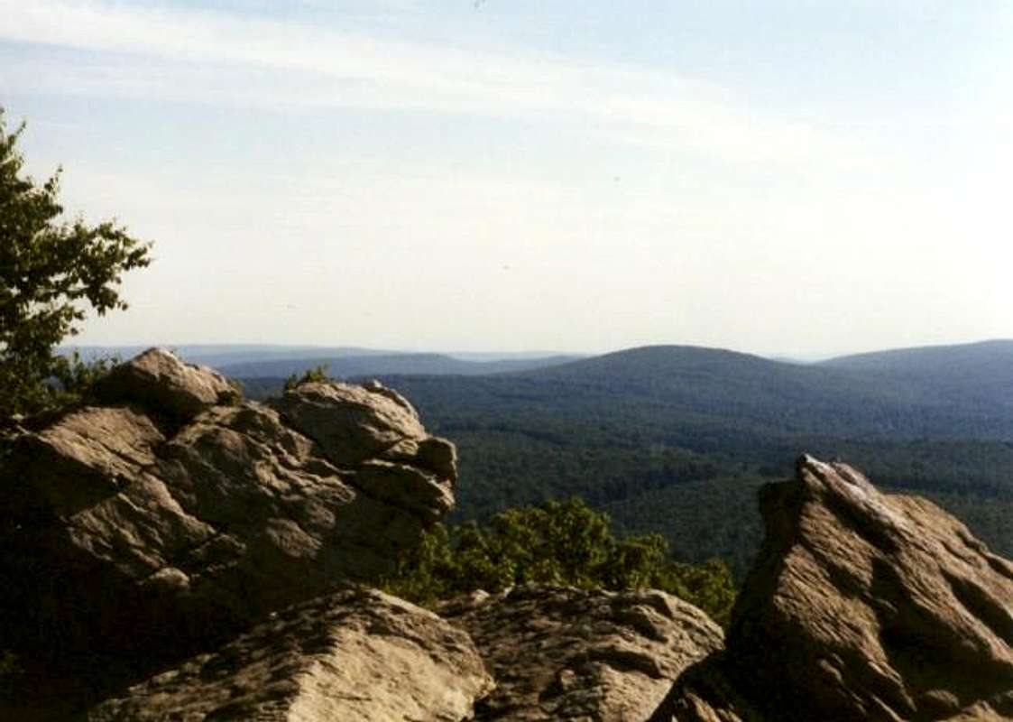
Buzzard Peak is located in the southern portion of Michaux State Forest and shares a saddle with its' larger neighbor, Snowy Mountain . This section of mountains is blazed by a section of the Appalachian Trail for about forty miles. This little mountain range is known for its' rock outcroppings and famous rock climbing locations. Some of the more famous areas include Schaffer Rock and Chimney Rocks ( which makes up the summit block of Buzzard Peak). Also, it is nicely situated only fifteen miles from Gettysburg and four miles northeast of Waynesboro.
The area is also known for Penn State's Mont Alto Forestry campus on the west side of the range. The mountains for the most part are not terribly rugged, but they provide a wonderful place to hike and quite a few technical climbing routes as stated above. The Peak rises steadily from the valley floor just to the northeast of Waynesboro. Chimney Rocks juts out from the top and provides wonderful views to the east, north, and south. Buzzard Peak gets its' name from the buzzards that built nests throughout Chimney Rocks. There are still a few nests around for the adventurous hearts who wish to explore the naturally formed caves from the rock. These caves are built up underneath the summit block. The views are beautiful and well worth the short hike to the top. It would make an excellent venue in which to view an early morning Pennsylvania sunrise.
 |  |  |  |
Getting There
The most common places of entry are from Gettysburg and Waynesboro.
From the east (Gettysburg):
• From U.S. route 15 get off onto the York St. or Route 30 (Lincoln Highway) exit for Gettysburg. Take 30 west through town and continue for fifteen miles into Michaux State Park. You will then reach the highway 233 jct. and you'll want to head south. Continue for six miles to either the town of South Mountain (for the southern A.T. trailhead) or turn right and continue onto route 233.
• From South Mountain: head east on Cold Spring Road through town and then after approximately two miles turn right onto Old Forge Road and continue to the Appalachian Trail sign which is the trailhead for the southern approach (on the north side of the road). There is parking available.
• From 233 (northern trailhead): After turning right at the intersection the A.T. sigh is only .3 miles on the left side of the road. The trail on the south side of the road is the trailhead for the northern approach.
From the west (Waynesboro):
• From town head east on highway 36 for about 3 miles. From here get on Old Forge Road and continue into the mountains and into Michaux State Forest. You’ll then reach the A.T. sign and your trailhead is on the north (left) side of the road.
Interstate 81 access:
• From either direction on I-81, get off onto the exit for highway 233 and follow the directions listed above.
 |  |
Red Tape
There are no permits or fees required for hiking in Michaux State Park. It is open all year round with possible road closures during the winter. All State conservation rules apply for garbage and pack it in, pack it out rules. Follow the Leave No Trace system and you'll be fine. Free parking is available at both trailheads. There is room for probably five cars, but don't worry as there shouldn't be herds of people in your way.
When To Climb
For the best views, fall or early winter would be the best time to summit Buzzard Peak just because the leaves would be off the trees and views would be wonderful the entire trip up. Views on top are phenominal all year round. In winter conditions with snow and ice, crampoons may be needed, especially for the summit block.
Camping
There are many places within the Michaux State park to camp, but you'll want to contact the park office at (717)352-2211. They'll get you information about all available camping areas in the park.
For more park information go to:
www.dcnr.state.pa.us/forestry/forests/michaux.htm
You can also write to
Michaux State Forest
10099 Lincoln Way East
Fayetteville, PA 17222-9609
Shelters
There are three shelters within the immediate area of Buzzard Peak. The closest is Tumbling Run Shelter which has two shelters, a spring, and a bathroom. It is maintained by the Potomac Appalachian Trail Club as are the other two. The other shelter is Hermitage Cabin which is on reservation from the PATC. You can call their offices at (703) 242-0965. Also on the other side of the road from the trailhead is Antietam Shelter which is similar to the Tumbling Run Shelter. Tumbling Run and Antietam Shelters are good for emergency use throughout all times of the year.
Mountain Conditions
For current and up-to-date weather conditions click on the link below!
weather.com
External Links
- Michaux State Park
This page contains all provided information by the state of Pennsylvania about Michaux State Forest and Park.
- Appalachian Trail
This is the official website of the Appalachian Trail from Maine to Georgia. It contains lots of useful information about the trail.
- Potomac Appalachian Trail Club
This page is from the PATC and gives information on the stretch of trail maintained by the PATC as well as trail guides and publications.
birdny - Nov 10, 2010 8:46 am - Voted 10/10
linksyour links for Michaux State Forest are no longer good, they should be http://www.dcnr.state.pa.us/forestry/stateforests/michaux.aspx
Cascade Scrambler - Jun 2, 2011 10:57 am - Hasn't voted
"Getting There" clarifiedFirst, as birdny pointed out well over a year ago, the links need to be updated for Michaux State Forest. Second, a clarification on the "Getting There" directions from Gettysburg and I-81. From the 233/30 junction, drive 4.15 miles south on 233/ Rocky Mountain Road. At the "T" intersection, do not continue to follow 233; turn left and drive towards (and past) the South Mountain Restoration Center (signed). 1.7 miles after the "T" intersection, turn right on Old Forge road. The Appalachian Trail crossing will be in 3.4 miles. There is room for parking for less than 10 cars in three different pullouts, but it doesn't seem to be an issue.