

-
 53913 Hits
-
 85.87% Score
-
 21 Votes
|
|
Mountain/Rock |
|---|---|
|
|
46.68622°N / 8.07585°E |
|
|
Mountaineering, Scrambling, Via Ferrata |
|
|
9606 ft / 2928 m |
|
|
 Schwarzhorn from the west after a summer dusting of new snow.
The right skyline is the SW Ridge.
 From the north
Overview
 From the SW
Considered to be part of the Berner Voralpen - the Bernese Prealps - the Schwarzhorn is dominated by the mighty summits of the Bernese Alps from the Wetterhorn west to the Jungfrau and beyond. However, this peak makes for a nice day climb and offers some grand views. It's a good trip to get to know the really crumbly, layered rock so typical of the area. While the Schwarzhorn presents few technical difficulties and can be done solo, it does require one to pay attention on the final, exposed summit ridge. It is the highest and most easterly summit in the subrange that starts from Männlichen and includes the Faulhorn, Reeti and Simelihorn and Wildgerst.
Getting There
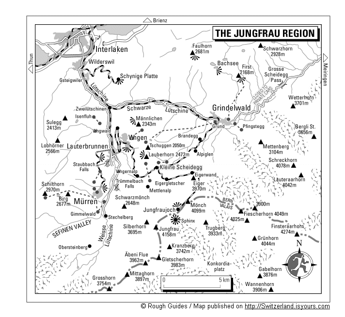
Grindelwald can by reached by rail or car from Interlaken.The First gondola , which starts from nearly the center of town, takes you to the First, a broad basin area. One can hike up to First, about a 3 hour hike. One first follows a well-maintained wide trail towards the Grosse Scheidegg around into another basin, Distelboden from where a smaller trail takes off towards Schwarzhorn.
See the topo and the Jungfrau overview map.
Routes Overview

There are only 2 routes described for the Schwarzhorn and both are easy to find.
SW Flank and South Ridge: This is the regular route and continues on the trail from Distelboden up the SW flank to the south ridge. Once on the ridge, follow it to the summit. At one point there is a very large gap, which is protected by fixed chains. Down climb on them to the notch and then scrambles back up to the final summit ridge. You can also leave the trail earlier, climb straight up the SW face directly to this notch. 2.5 hours from First, rated EB (experienced mountain walker). (YDS Class 1 and 2 with one very short piece of Class 3.)
SW Ridge: This used to be a technical route of UIAA II (YDS Class 4), but has been turned into a Klettersteig (Via Ferrata) with many ladders. The first ladder is easily seen from the Distelboden. Leave the trail to the SW flank at about 2500m elevation and heads in a NW direction towards the pass called the Grossi Chrinne. The final slopes to the pass are over large plates that are ascended through a series of ramps to the right of the couloir.
Descent
The regular route can be followed back to First. You can drop down to one of the intermediate stations on the First gondola to avoid having to walk back up to First. One can also continue on the main trail to Grosse Scheidegg and either take a Post bus back to Grindelwald or walk back into town. It is also possible to descend an east facing couloir between Gemsberg and Schwarzhorn to access the Grosse Scheidegg trail.
 On South Ridge On South Ridge |
 Kletterstieg ladders Kletterstieg ladders |
 On Kletterstieg On Kletterstieg |
Summit Views
 To Eiger & Mönch To Eiger & Mönch |
 Wetterhorn WetterhornSchreckhorn |
 Eiger etc. Eiger etc. |
Accommodations
The Grindelwald, Lauterbrunnen and Interlaken offer a large variety of hotels, hostels and camping grounds. This is a very heavily visited part of Switzerland and reservations are needed. It would be possible to do this climb from Interlaken, if one left early and took an early gondola. The first gondola up is 8am, the last one down is 6pm.External Links
- Pictures of the Bernese Oberland
Fantastic views of the Bernese Oberland