

-
 80731 Hits
-
 94.82% Score
-
 49 Votes
|
|
Mountain/Rock |
|---|---|
|
|
48.72840°N / 113.6497°W |
|
|
Mountaineering, Scrambling |
|
|
10014 ft / 3052 m |
|
|
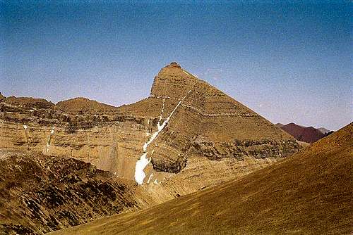
Overview
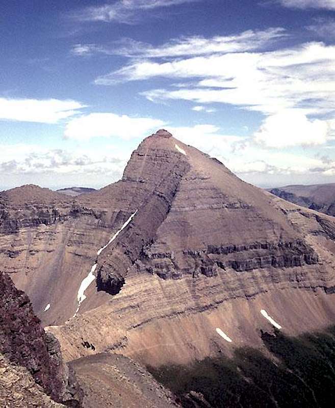
Mount Siyeh from the southwest.
Mount Siyeh is located about four miles northeast of Logan Pass in Glacier National Park. It is the fifth highest peak in the Park, one of just six peaks in the park over ten thousand feet in elevation. The peak has a rather unimpressive hump shape viewed from the south, but has a much nicer profile from the west and east. The north face is one of the highest rock faces in the Lower 48, and to the best of my knowledge, has been climbed only two times.
The mountain was named by G. B. Grinnell for a Blackfeet Indian, "Sai-yeh," who was described as being so recklessly brave that after a time none of his fellow tribal members would go with him on raids against the enemy. In Blackfeet "Sai-yeh" means Crazy Dog, or Mad Wolf.
Views of Mount Siyeh
 From the south. From the south. |
 From the north. From the north. |
 From the northwest. From the northwest. |
 From the east. From the east. |
 From above Siyeh Pass From above Siyeh Pass |
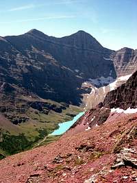
Getting There

View to Siyeh Bend.
Glacier National Park is located in northwestern Montana. Going-to-the-Sun Road is the main scenic route through the Park and the way to Logan Pass and Reynolds Mountain. It is not kept open during the winter. Closing in the fall and opening in the spring depends on snow depth and conditions. Opening can be as late as July.
Current Road Status
The two most common routes on Mount Siyeh (South Slope & Piegan Pass) are most easily approached via the Piegan Pass Trail starting at Siyeh Bend about 3 miles east of Logan Pass on the Going to the Sun Road.
Piegan Pass can also be reached from Many Glacier, but this adds 4 miles (one way) to the hike.
Logan Pass Area Trail Map
The West Couloir is best approached via the Piegan Pass Trail from Many Glacier.
Mount Wynn is climbed from the Cracker Lake Trail starting at Many Glacier.
Many Glacier Area Trail Map
Routes Overview
GUIDEBOOK: A CLIMBER'S GUIDE TO GLACIER NATIONAL PARK; J. Gordon Edwards
SPECIAL CONSIDERATIONS:
Because of the nature of the rock, there are special considerations regarding climbing in Glacier National Park, and grading systems unique to the Park have been developed. Please see this Fact Sheet for further details:
GNP Rock & Grading Systems

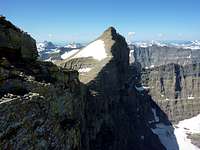
South Slope from below.
South Slope : Class 2 and 3 with care in route finding. There is the possibility of a Class 4 pitch through the diorite sill depending on exactly where it is climbed. About 4,200 feet of vertical gain from Siyeh Bend over five miles about half of which is on trail.
A detailed route description is included in CLIMB GLACIER NATIONAL PARK Volume 1
Piegan Pass : Class 2 and 3 with care in route finding. About 4,200 feet of vertical gain from Siyeh Bend over about 7 miles, 4.5 of which is trail (about 11 miles with 8.5 of trail from Many Glacier).
From just east of Piegan Pass, ascend a goat trail toward the saddle east of Cataract Mountain. At the cliff barrier on the ridge, traverse southeast to a class 3 couloir and climb it back to the ridge top which is then followed without difficulty to the summit.
West Couloir : Not recommended in ascent, but apparently a great 1,500 foot scree run down when free of snow. It brings one down to the trail on the Many Glacier side of Piegan Pass in the area of Morning Eagle Falls.
Mount Wynn (traverse) : A 5 to 5.5 mile high ridge traverse from the summit of Mount Wynn to Mount Siyeh. Class 2 and 3 including the climb of Mount Wynn.
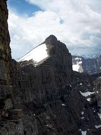
North Face.
North Face : An extremely difficult climb, rated Grade V or VI 5.9, A2. This is probably the most difficult climb in the Park. It was first climbed 13, 14, & 15 September 1979 by Jim Kanzler and Terry Kennedy on their fourth attempt. They reported 25 or 26 hours of actual climbing with 25 belayed pitches plus some 1,000 feet done third class.
Details appear in Volume 1 Number 1 (Jan. - June 1980) GOING-TO-THE-SUN MAGAZINE and the JOURNAL OF THE GLACIER MOUNTAINEERING SOCIETY, No. 36, 2005.
The face finally got a second ascent 14 & 15 August 2005 by Ben Smith and Justin Woods. They followed roughly the same line as the first ascent party free climbing the entire route which they rated 5.10+ R with much loose rock and poor protection.
Red Tape
Current Entrance Fees
Registration for day climbs in Glacier National Park is recommended, but not mandatory.
Outdoor Activity Page Includes links to boating, bicycling, fishing, etc. and the regulations applying to each.
When To Climb

South Slope Route
June, July, August, September, and even into October depending on the amount of snow and the road closures.
Camping
There are numerous campgrounds available within Glacier National Park:
Backcountry Camping Page Includes trail status reports, campground availability, daily backcountry bulletins, and a backcountry blog.
Car Camping Page
There are also many campgrounds just outside the Park on both the west and east sides.
Camping on the Blackfeet Reservation is restricted to established campgrounds only.
Mountain Conditions
Weather Page an overview with a link to the local forecast.
Webcam Page
External Links
Glacier National Park Homepage
Glacier Mountaineering Society
Non-government Glacier National Park Information
 Mount Siyeh from the west.Photo by saintgrizzly