
|
|
Mountain/Rock |
|---|---|
|
|
46.43978°N / 13.83041°E |
|
|
Hiking, Mountaineering, Sport Climbing, Ice Climbing, Big Wall, Mixed, Scrambling, Skiing |
|
|
Spring, Summer, Fall, Winter |
|
|
8599 ft / 2621 m |
|
|
Overview
Geographical structure: Eastern Alps > Julian Alps > Martuljek group.The name means in English (big altar).
Veliki Oltar is one of the highest mountains in Martuljek group. It leads in the main ridge of Martuljek group. From the village Gozd Martuljek it can be observed in the famous view of these mountains. It is very heterogeneous mountain because to each side it is showing different ground, screes, sheer slopes, faces, couloirs…
From north, Martuljek group looks like a broad, slightly curved crest of wild, rugged peaks. This range starts on NE with Vrtaski vrh, 1898m, continues towards W-SW over Sleme, 2077m and reaches the sharp Kukova spica 2427m, with which a beautiful half circle of high mountains starts. Skrnatarica 2448m, Dovski kriz 2542m, Veliki Oltar, 2621m and from this one in a NW direction Velika Ponca, 2602m, Mala Ponca, 2502m, Spik 2472m, Frdamane police, 2284m, Rusica, 2074m. In front of this ridge leads a very hard approachable mountain called Siroka pec. It is nice seen with its steep N face from Gozd Martuljek.
Veliki Oltar continues the ridge in the SW direction towards the second highest mountain called Skrlatica. Between them is a mountain called Visoki Rokav 2646m. It is also very hard mountain for climbing. Very crumbly, steep and so on...
Veliki Oltar is approachable from more sites. From SE, W, N and NE. Every side has slopes with its own difficulty. There is no marked route to Veliki Oltar. Only from the N side leads marked route but only to the Bivak III (the Bivouac III) on the altitude 1340m. You can only find hunting routes or some unmarked paths. But in mostly you have to find your own way. But don’t be afraid, now the normal route is very popular and to the Bivak II (the Bivouac II) on the altitude 2118m you come by the nice trodden hunting route.
Veliki Oltar is also nice skiing mountain but for skiers which have a lot of experience in tour and alpinist skiing. Nice route goes from north through the couloir called Kacji jezik (the Snake tongue).
 |  |  |  |  |
Getting There
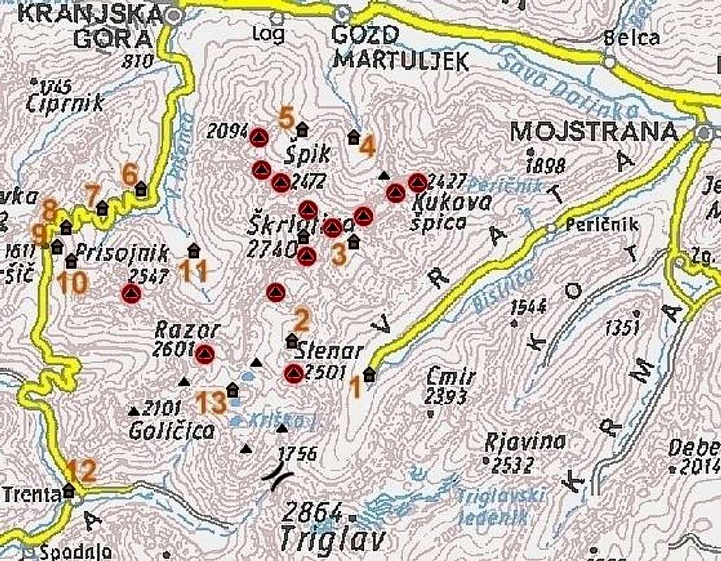
The main valley to start climbing on Veliki Oltar is Sava valley. If you go from Ljubljana you travel by highway towards NW, through Jesenice and further to Mojstrana, Martuljek or Kranjska Gora (from Kranjska Gora on the road to the Vrsic pass and then turning to Krnica valley).
If you climb on Veliki Oltar from south you start in the famous Vrata valley, going from Mojstrana village to foothills of Triglav. The trailhead starts on Poldov rovt (meadow), some 2 km before Aljazev dom (hut). Less than 2 hours walk from Mojstrana. Here you have parking place and stone signpost.
From west side you drive from Kranjska Gora to the branch to the Krnica valley and Koca v Krnici (hut). Here you park and proceed to the Koca v Krnici (hut). On the way you go by another bivouac called Bivak I. It is very small but you can sleep there.
If you want to climb on Veliki Oltar from north you drive to village Gozd Martuljek where you follow the signpost for Bivak III (the Bivouac III) and walking route number 6.
Maps:
Kranjska Gora. Community of Kranjska Gora - Tourist map. 1:30000
Julijske Alpe - Vzhodni del (Eastern part). Planinska zveza Slovenije. 1:50000.
Triglav. Planinska zveza Slovenije. 1:25000
 |  |  |  |
Routes Overview
 Veliki Oltar and some of its routes.
There are many possibilities for climbing on Veliki Oltar. Many of them are also described here on the route pages of Veliki Oltar. Here is the list:
 Normal route from Vrata valley by bivouac II. The medium hard ascent. Some climbing UIAA I-II on the upper part. Description. From the Vrata valley through the valley Na Brinju. The medium hard ascent. Some climbing UIAA I-II on the upper part. Description. From Krnica valley (west side) over the basin Velika Dnina and over the N ridge. The meduim hard route, climbing UIAA II in the upper part, on the north ridge. Description. Over Kacji jezik (Snake's tongue) from the north side, from the village Gozd Martuljek. Medium hard climbing route UIAA II. Better in early season when there is more snow. Desription. From north side, from the village Gozd Martuljek over Grlo pass. Medium hard climbing route UIAA II. Description. NE ridge from the village Gozd Martuljek. Climbing route UIAA IV/III. Description. Climbing route Bucar - Kristan. Climbing route in the north face of Mali Oltar. UIAA IV-/III. Very nice climbing route. Climbing route Gros - Manfreda. The route over the north pillar of Mali Oltar. UIAA VI-/V.
View from Veliki Oltar
Veliki Oltar is mountain in the middle of Martuljek group and from it is nice view to all mountains in that group and far forward.You can see a Vrata valley and Krnica valley, Prisojnik, Razor, all mountains in Martuljek group, Triglav, Skrlatica, Cmir, and also Karavanke / Karawanken GROUP and Kamnik Alps group.
 |  |  |  |
Red Tape
Veliki Oltar is in Triglavski Narodni park. |
When To Climb
Best time from south is in June, July when is not very hot. From north is fine when snow stil lies. From west also when the snow still lies because this can make you easier come over the screes.For skiing through the Kacji jezik (the Snake tongue) are the best months March, April and May. Or in Winter months but be careful for avalanches.
 |
Camping
In Sava valley there are many huts and hotels. In Kranjska Gora, for example hotels: Lek, Larix, Kompas and many family hotels.Bivouacs II (6 beds), III (8 beds), I (3 beds) are maintained by Mountaineering Club Jesenice. Address: Cesta zelezarjev 1, 4270 Jesenice; tel.: (04) 586-60-70