
-
 45727 Hits
-
 93.04% Score
-
 41 Votes
|
|
Mountain/Rock |
|---|---|
|
|
48.58847°N / 120.70422°W |
|
|
Hiking, Mountaineering, Trad Climbing, Scrambling |
|
|
Summer, Fall |
|
|
8444 ft / 2574 m |
|
|
Overview
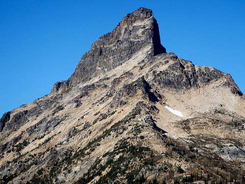 The East Face
As with many of Washington's highest mountains, Tower Mountain is part of a pair. It shares an east-west trending ridge with nearby Golden Horn. Most climbers who tackle the long approach will make a point of climbing both peaks. It's located on the Cascade crest between three major drainages, including Pine, Swamp, and Cataract creeks. In terms of rank, Tower Mountain has many respectable qualities. With 2884 feet of clean prominence and a height of 8444 feet, it is both the 66th most prominent peak and 66th highest peak in Washington. Furthermore, it is the 36th steepest peak in the state.
 The West Face
Tower Mountain was first climbed in 1913 by surveyors but the names of those men are unknown. That first ascent party built a 7 foot cairn which stands to this day, nearly 100 years later. Tower Mountain is not climbed as often as some of it's nearby neighbors. Certainly Silver Star Mountain, Black Peak, and Cutthroat Peak all see more ascents on any given year. Even Golden Horn gets more attention. A likely reason for this is the reputation for loose rock, but another factor might be the foreboding appearance.
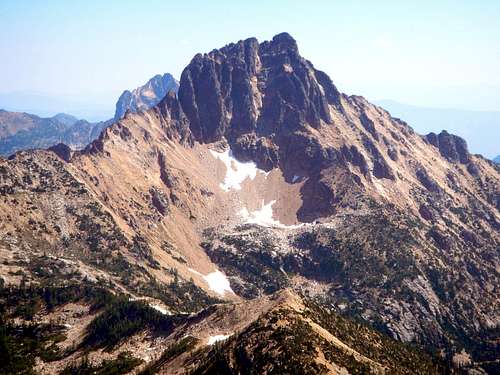
 The South Face
There are several possible approaches and climbing route options to choose from. The standard route entails high alpine lakes and stunning beauty of the Rainy Pass environs with golden-toned exposed granite and golden larches in the Fall. It offers great views to the west and north into the North Cascades mountain ranges and to the south into the Glacier Peak region. The west and south sides of the mountain consist of various gully systems allowing relatively easy climbing (class 3) but the east face presents a sheer vertical wall. The bedrock of the mountain is mostly solid, but much loose rock is scattered on the surface ledges. For that reason it is advised to keep group numbers to a minimum to avoid rockfall danger.
 The North Face
The Approach
There are four plausible approach routes to reach the base of the mountain; Swamp Creek drainage (no trail), Mount Hardy traverse (no initial trail), Cutthroat Lake (trail), the PCT from Rainy Pass (crowded trail). 95 percent of people choose to take the Pacific Crest Trail from Rainy Pass because it is scenic and requires the least amount of thought. This option loses 800 vertical feet in either direction.
For those who like to minimize distance and add on extra peaks, a traverse from Mount Hardy is the best choice. The Swamp Creek drainage option does cut down on distance but the steep climb out of the head of the basin might be more trouble than it's worth. Lastly, it is possible to come from Cutthroat creek to the east, and thereby also see Cutthroat Lake along the way, but this approach is no shorter than the PCT and adds 400 feet of elevation gain.
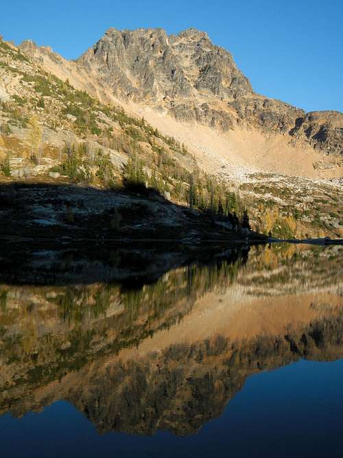 Tower Above Lower Snowy Lake
PCT from Rainy Pass to Cutthroat Pass
23 miles round-trip
From the Rainy Pass trailhead at 4880 feet on the east side of the highway, hike north on the PCT for several miles without gaining much elevation. The trail crosses several creeks before entering the Porcupine Creek drainage. The trail will follow the west side of the drainage to the head of the basin which is more open, affording views of Porcupine Peak. Above the head of the basin, multiple switchbacks ascend to Cutthroat Pass (6840 feet). Here, the PCT and Cutthroat Lake approaches converge.
From the junction, hike northeast (do not descend) on level ground along the PCT. The trail turns a corner and then proceeds north around another corner descending in switchbacks to Granite Pass. Above Granite Pass, Tower Mountain is finally visible. From Granite Pass (6280 feet) continue to follow the PCT, now is a northwesterly direction. This part of the trail could be treacherous when snow-covered. 2 miles beyond Granite Pass, the trail enters a flat basin just west of Tower Mountain. Watch for the obvious side trail which ascends north to Snowy Lakes. Another 500 or 600 vertical feet will bring you to camp, depending on which lake you prefer to stay at.
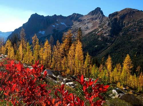 Fall Colors Below Cutthroat Pass
Cutthroat Lake to Cutthroat Pass
23 miles round-trip
From the trailhead hike east 2 miles through the Cutthroat Creek drainage. It is not necessary to go all the way to Cutthroat Lake (4960 feet). Rather, take the right fork junction and ascend many switchbacks to Cutthroat Pass (6840 feet). Here, the PCT and Cutthroat Lake approaches converge.
From the junction, hike northeast (do not descend) on level ground along the PCT. The trail turns a corner and then proceeds north around another corner descending in switchbacks to Granite Pass. Above Granite Pass, Tower Mountain is finally visible. From Granite Pass (6280 feet) continue to follow the PCT, now is a northwesterly direction. This part of the trail could be treacherous when snow-covered. 2 miles beyond Granite Pass, the trail enters a flat basin just west of Tower Mountain. Watch for the obvious side trail which ascends north to Snowy Lakes. Another 500 or 600 vertical feet will bring you to camp, depending on which lake you prefer to stay at.
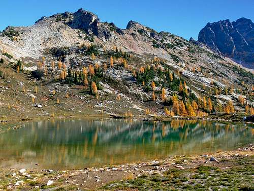 Upper Snowy Lake
Mount Hardy traverse via Swamp Creek
11 miles round-trip
The majority of hikers shy away from any route which is described as a bushwhack. Fortunately, the forest in the Rainy Pass area is rather light by Washington standards. Undergrowth is at a minimum and the trees are not densely packed. For the most part, it's open forest. From the pullout (3960 feet), walk northwest along the guardrail and cross to the north side of Swamp Creek. Beyond the guardrail, cut into the forest. Ascend westerly along a series of small ridges.
Around 4800 feet turn onto a north-bearing ascent. Between 5000 and 6000 feet there will be some evidence of an old fire with a few fallen logs and some smaller denser trees. Above 6000 feet the terrain is completely open and very easy to travel. Without snow, there is some scree here. Continue to climb Mount Hardy's broad south ridge to 7200 feet where a traverse to the east is easiest. 900 feet below the summit of Mount Hardy, traverse the loose scree and talus covered south face over to the east ridge.
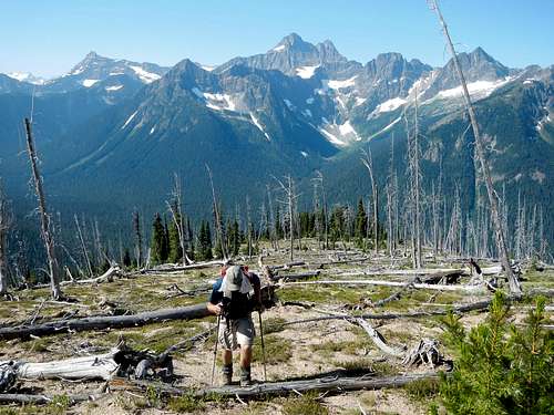 The Broad Open South Ridge Of Mount Hardy
Follow the ridge-crest down to Methow Pass (6600 feet) and the PCT. From the pass, it's just a short mile hike eastward to the flat basin and Snowy Lakes trail junction. Watch for the obvious side trail on the left. Ascend north another 500 or 600 vertical feet to camp, depending on which lake you prefer to stay at.
Swamp Creek drainage to Snowy Lakes
10 miles round-trip
This option saves distance but not necessarily any time. Beware of marshy ground and a few patches of slide alder. From the pullout (3960 feet) bushwhack along the east side of Swamp Creek and cross the creek to the north bank at 4950 feet. This should avoid the marshiest areas. 3 miles from the highway, around 5100 feet, turn north and ascend out of the drainage. The slope is steep and loose. It may be beneficial to make use of various small avalanche gullies. The PCT is encountered at 6300. From there make your way to the flat basin and Snowy Lakes trail.
Standard Route - West Face Main Gully (class 3)
From Lower Snow Lake make a slightly ascending traverse toward the west face of Tower Mountain. Cross talus and scree staying below minor cliffs. Passing through or above some scrub bushes, you will reach the main talus slope below the west face. Access to the main gully is blocked by a large headwall. The best way to bypass this headwall is the cave ledge system. The mouth of the cave itself is 20 feet high and visible from Snowy Lakes.
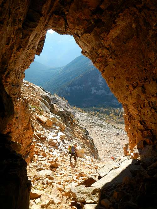 The Cave
Climb talus and scree along the left (west) side of the headwall to access the beginning of the ledge system. From below, the ledge appears daunting, but it's not as exposed as it looks. The ledge crosses above the headwall to the mouth of the cave. Beyond the cave it reaches the entrance to the main gully.
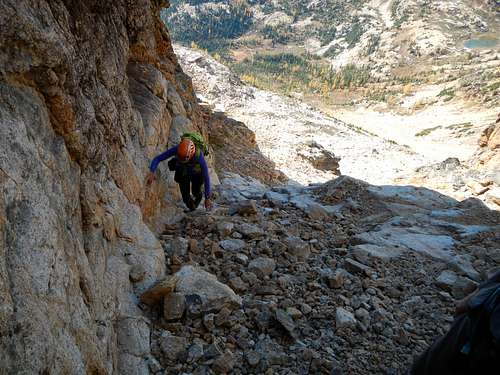 Entering The Gully
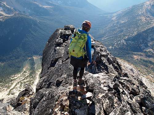
The middle and left sides of the gully tend to be steeper and more exposed while the right side has more features, more ledges, and usually lots of cairns. The center of the gully is often a whiter shade of rock with very few features. This route should never exceed class 3 although it comes close a few times. Remember to be careful of loose rock. Parties should not be greater than 3 or 4 and should stay close together.
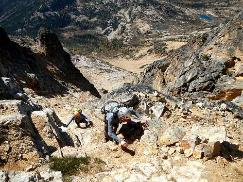 Climbers In The "Brown Gully"
Scramble the ledges on the right side of the gully zigzagging back and forth to reach higher ground. Sometimes it is necessary to scramble away from the gully for a spell but the route will always return into the gully. After about 150 feet of scrambling, ledges lead back to the center of the gully where a small promontory sticks up out of the center. Here another ledge system leads far to the right again before coming back to the center below the "brown gully". The "brown gully" is sort of a mini gully inside the main gully, and has slightly darker rock. Scramble up the center of the "brown gully". The alternative on either side is more technical.
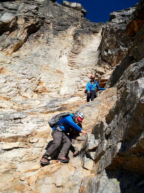 Climbers Below The White V
Above the "brown gully" you will be nearing the white headwall at the top of the gully with a distinct white V. Scramble to the very base of the white V and then go through a little notch up to the right and out of the gully. Avoid the temptation to ascend too quickly here. Some of the ledges above will end in technical climbing. It's better to traverse southward towards the south ridge. Follow cairns and a few more ledges looking for the best place to gain the south ridge. It's easy to get off track at this point so explore your options.
 Exposed Section On The South Ridge
Once on the crest of the south ridge, some more class 3, with one exposed move, takes you to the summit, where the famous cairn stands 7 feet tall. It's believed that the original summit party built this cairn in 1913.
Driving Directions - Highway 20
A Northwest Forest Pass is required at the trailhead. Registration at Marblemount Ranger Station is not required as the peak is outside the park.
Swamp Creek pullout parking area - Located on the north side of the highway 3 miles east of Easy Pass trailhead and 3.7 miles west of Rainy Pass.
Rainy Pass trailhead and parking area is located 4.7 miles west of Washington Pass.
The Cutthroat Lake trail is east of Washington Pass. From the pass drive 4.7 miles to Cutthroat Creek road (National Forest Road 400) on the west side of the highway. Follow this road one mile to trailhead.
Camping
There are excellent campsites along the PCT and especially at the Snowy Lakes area right at the base of the mountain.
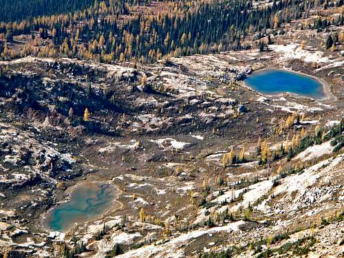 Snowy Lakes Seen From The Summit
External Links
- Recreation passes of the Northwest
Info for user fee options. - North Cascades Visitor Information
Road conditions for Highway 20
Also other related information for the North Cascades region.
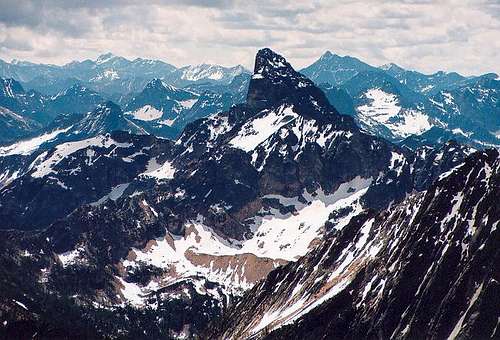
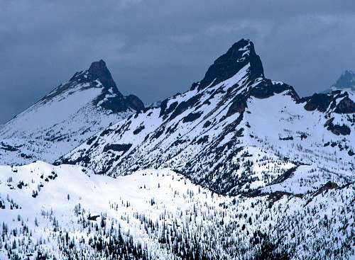 Golden Horn And Tower In Stormy Conditions
Trip Reports
- October 2006 trip report by b00
- August 2007 trip report by Roald
- September 2009 trip report by Tazz
- September 2009 trip report by Franklin Bradshaw
- September 2009 trip report by faelynn
- October 2010 trip report by Huron
- October 2010 trip report by John Morrow
- October 2012 trip report by gimpilator