
|
|
Mountain/Rock |
|---|---|
|
|
46.42546°N / 13.81509°E |
|
|
Hiking, Mountaineering, Trad Climbing, Big Wall, Mixed, Scrambling, Skiing |
|
|
Spring, Summer, Fall, Winter |
|
|
8500 ft / 2591 m |
|
|
Overview
Geographical structure: Eastern Alps > Julian Alps > Martuljek group.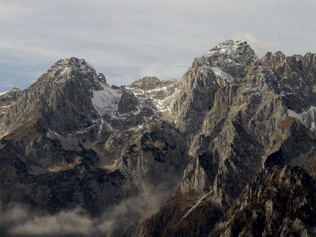
Dolkova spica (on the left) and Skrlatica from the SE way.
Dolkova spica is the ninth highest mountain in Slovenia and it’s the last mountain, which belongs to Martuljek group. It is not in the main group but it is in the secondary ridge which comes from Skrlatica, 2740m, from the NE way. Dolkova spica makes with Rogljica, 2547m a beautiful bulk of two peaks which are separated with notch Rdeca skrbina. From here this ridge goes over Dovski Gamsovec, 2440m and some not very important peaks to the top of Kriska stena, 2289m. Kriska stena is the end of Krnica valley. From the top of Dolkova spica goes in way SE a airy ridge which ends on Spodnja Dolkova spica , 2541m.On the SE slopes of Spodnja Dolkova spica goes one of the marked routes on Skrlatica. From here Spodnja Dolkova spica falls very steeply down to the Vrata valley.
Dolkova spica is the mountain which is not hard approachable. A normal route is nice marked route, which is not too hard and has some secured places on the upper ridge. A lot of climbers climb on Dolkova spica when they are reaching higher neighbour Skrlatica. Because on notch Rdeca skrbina goes one of the routes on Skrlatica and from Rdeca skrbina is not to far to the summit of Dolkova spica.
The main starting points for ascend on Dolkova spica are the Krnica valley and the Vrata valley. From both go on the summit marked routes, which are combined on the top of Kriska stena or on the notch Rdeca skrbina.
On the route from the Vrata valley you go by Bivouac IVwhich leads on the plateau between Dolkova spica and Stenar, 2501m.
 |  |  |  |  |
Valleys
Vrata valleyVrata (Door) is probably the most beautiful alpine valley in Slovenia. It is glacial valley, beginning bellow mighty Triglav and it’s gigantic north wall, spreading towards northeast till Mojstrana village and upper Savska Dolina valley. Powerful creek Triglavska Bistrica runs through it, which source is just bellow Triglav’s Face. Sides of the Vrata valley are very steep and high. Two of the Slovenia’s highest peaks are rising above it. On the north side is Skrlatica (2740m) while on the south is Triglav (2864m) and many other above 2500m. View on Triglav’s 1200m high and few kilometers wide north face is one of the most impressive in whole of the Alps!
Krnica valley
Starting point of one of the routes is Koca v Krnici hut(1113m), which lies in Krnica valley. The valley is beautiful, with stunning scenery. All around are some of the highest peaks of Julian Alps that fall into the valley with huge walls: Skrlatica (2740m), Rakova Spica (2545m), Razor (2601m) and Prisojnik (2547m). Krnica ends with probably most beautiful amphitheater in Julian Alps – Kriska Stena.
Hut is accessible from Kranjska Gora to Vrsic pass road. Junction towards the hut is some 2 kilometers behind Kranjska Gora, just at the bridge where main road crosses over Pisnica river to the right, you continue straight. From the bridge is 3 kilometers to V Klinu pasture where you have to park. From here is 20 more minutes to the hut. If you are on foot from Kranjska Gora you will need 1.30-2h.
Getting There
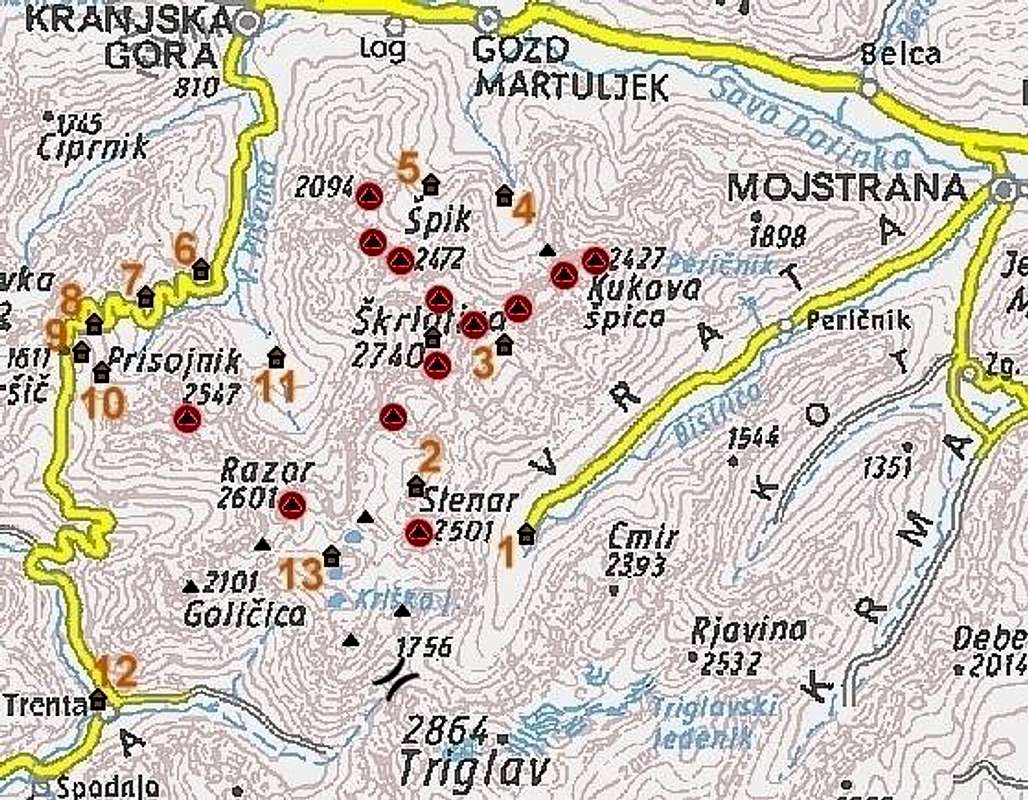
Dolkova spica is just in nearness of Skrlatica. Here you can see where exactly is Dolkova spica. Red spots are mountains which have own pages on SP.
The heart of the region is Kranjska Gora resort town, 84 kilometers from the Slovenian capital Ljubljana. Starting point for Dolkova spica is valley Krnica or Vrata valley.
By Plane:
If you want to reach Ljubljana by plane check a timetable on the site of Adria Airways, a national airline.
By Bus:
From Ljubljana buses depart towards Kranjska Gora every 60 minutes.
By Train:
From Ljubljana trains depart in Kranjska Gora direction quite often but only up to Jesenice town. There you have to change to bus, which come from Ljubljana anyway.
By Car:
From Ljubljana 84km.
From central Europe via Villach, Austria: Via Karavanke tunnel (around 40km) or Korensko Sedlo pass (around 30km).
From western Europe via Udine, Italy: exit Udine – Villach highway in Tarvisio. Tarvisio – Kranjska Gora – Gozd Martuljek 25km.
Maps:
Kranjska Gora. Community of Kranjska Gora - Tourist map. 1:30000
Julijske Alpe - Vzhodni del (Eastern part). Planinska zveza Slovenije. 1:50000.
Triglav. Planinska zveza Slovenije. 1:25000
 |  |
Routes Overview
On the Dolkova spica you can come from Krnica valley and from Vrata valley.Both marked routes from both valleys are described in routes section.
Very nice climbing tour is SE ridge of Dolkova spica which has difficulty around UIAA II.
 |  |
Red Tape
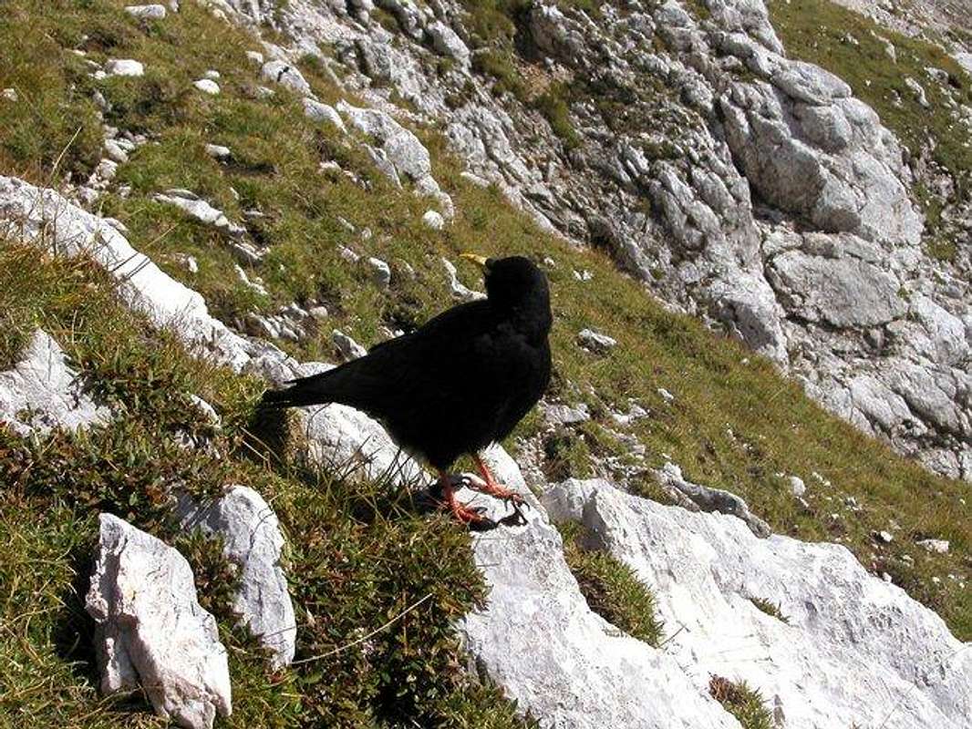
A mountain jackdaw.
No limitations but Dolkova spica leads in Triglavski Narodni park so you must be kind to the nature and other beauties.
When To Climb
The best season to climb Dolkova spica is from July to October.You can also ski there but you must be good tour skier.
For skiing the best months are April and May - when the conditions are safe of avalanches.
Camping and huts
Camping inside the National Park is forbidden. Beside the mountain huts there are plenty of hotels and private apartments in the towns and villages, which surround the area.In Sava valley there are many huts and hotels. In Kranjska Gora, for example hotels: Lek, Larix, Kompas and many family hotels.
There are three huts: Koca v Krnici, Aljazev dom in Vrata valley and in nearness Pogacnikov dom na Krskih podih.
Here are some information about huts:
KOCA V KRNICI hut (1113m) stands on a small meadow in conifer forest on the bottom of Krnica valley. The valley is surrounded by high peaks: Skrlatica (2740m), Razor (2601m) and Prisojnik (2547m). Opening year was 1933. It is open from May 1st till October 31st, while outside that frame during weekends and holidays. It has 20 beds, water and power from a generator.
POGACNIKOV DOM NA KRISKIH PODIH hut (2050m) is standing on the edge of Kriski Podi basin, high above the Trenta valley. Kriski Podi are bare rock basin, which is ascending in few steps. At the foothills of those steps lie 3 beautiful alpine lakes: lower, middle and upper Krisko jezero lakes. Area is surrounded from 3 sides by peak. Highest of them is Razor (2601m). The hut was opened in 1951 and named after a Joze Pogacnik whose idea was to build a hut here. Unfortunately he died on the way from Trenta valley to hut opening ceremony. In 1985, near the hut, load aerial ropeway and winter room were built. The hut is open from July 1st till the end of September. It has 67 beds + 16 in winter room, water and electricity from a generator. View from the hut is beautiful towards Trenta valley and Soca River, which shines on the afternoon sun and the wild peaks around.
ALJAZEV DOM hut (1015m) is placed in Vrata valley. It is accessible by car, 12km from Mojstrana village, which lies on the main road from Ljubljana to Kranjska Gora resort. It was opened in 1896. In 1909. the hut was destroyed by avalanche. New hut was opened the next year where it stands today. It has 150 beds and is open from beginning of May till the end of October. Winter room has 8 beds. From the hut view is beautiful on the peaks around the valley, which rise wildly above it and especially on Triglav and its North face.
Also there is bivouac on the plateau between Stenar and Dolkova spica.
BIVAK IV NA RUSJU bivouac (1980m) stands high above Vrata valley, on the slopes bellow Dolkova Spica (2591m) and Stenar (2501m), since 1948. During the 1950/51 winter it was blown away in the storm and ended up some 80 meters away. In 1953 a new one has been built. It is constantly open and has 10 sleeping places, furnace and water reservoir.
Mountain Conditions
Mountain conditions in Julian Alps are well known, thanks to Kredarica (2515m) hut and meteo station, which is bellow the Triglav.You can observe current conditions and forecast for Kredarica on the Wunderground meteo site. Here is direct link to Wunderground - Kredarica page.
Some weather informatin can also be found here.
 |