
-
 51136 Hits
-
 94.63% Score
-
 48 Votes
|
|
Mountain/Rock |
|---|---|
|
|
37.95510°N / 105.5337°W |
|
|
13266 ft / 4043 m |
|
|
Overview
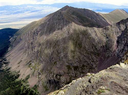
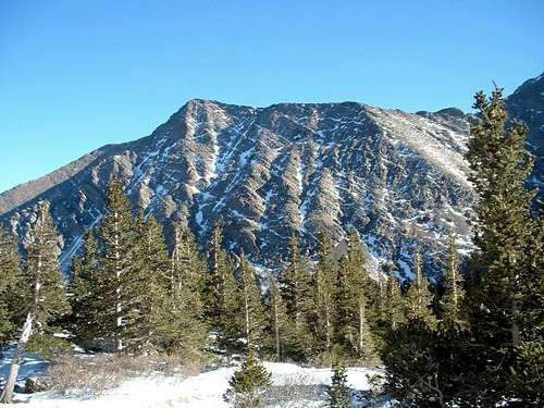
Marble Mountain from the summit of Broken Hand Peak | Ryan Schilling
Marble Mountain is a great peak among many situated in the heart of the Sangre de Cristo range. The peak is easy to identify as it flanks the south side of South Colony Creek Valley and Humboldt Peak. Although climbing Marble itself has rewards of its own, the best thing about the mountain is the views of the mighty Crestones to the northwest.
Marble Mountain is a rather benign peak compared to its fourteener neighbors and offers a relatively moderate hike to the summit in an area surrounded by difficult mountains. The route is a nice hike through conifer, followed by a final summit push of alpine tundra and talus. The mountain also offers a good winter climb due to virtually non-existent avalanche danger via the northeast ridge.
The Sangre de Cristo mountain range is a spectacular collection of peaks which stretches 250 miles from Santa Fe, New Mexico to Salida, Colorado. Please note the left side bar which features all the mountains in the Sangre de Cristos, both in Colorado and New Mexico.
Rank: 427th highest peak in Colorado
Prominence: 526 feet
USGS Quad: Crestone Peak
Planning Maps: Trails Illustrated #138 | Sangre de Cristo Mountains and San Isabel National Forest Map
Rank & Prominence: Lists of John
![DATE AND TIME: 112106, 1103;]()
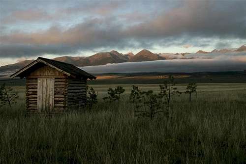
A late-morning view of the east side of the Sangre de Cristos, taken from the Wet Mountain Valley. Photo by dherrera96
Marble Mountain is located in south central Colorado approximately 12 miles southwest of Westcliffe. The trailhead for the standard route is the Rainbow Trailhead, and is gained via the South Colony Road on the east side of the range near Westcliffe. The other trailhead is the Music Pass trailhead and climbs the mountain via the south ridge of Point 12,739. See the link for directions to the Music Pass trailhead.
From Westcliffe, Colorado: Drive southwest on highway 69 about 4.5 miles to Colfax Lane (CO119) where there is a Forest Service sign. Turn right (south) and go another 5.5 miles until the road ends, then turn right (going west) on South Colony Road (Forest Service Road 120) for 1.5 miles where there is a fairly large parking lot on the right. 2WD vehicles should park here. The next three miles are a 4WD road (FR120). This road has been improved within the last year and is much easier to negotiate than previous years. A sturdy 2-wheel drive SUV should be able to make it past the lower parking area to the TH. After three miles up South Colony road, a sign will greet you which indicates the Rainbow Trail. Minimal parking is available at the trailhead, but please do not block the road.
Once at the Rainbow Trailhead, head south and follow the Northeast Ridge Route.
![Marble Mountain]()
Marble Mountain with South Colony Lake in the foreground.
San Isabel National Forest, San Carlos Ranger District, 3170 E. Main, Canon City, CO 81212. Phone: (719) 269-8500, Fax: (719) 269-8719. Westcliffe has a small one-man ranger station: (719) 783-2079. The local ranger is currently Jeff Outhier.
Private Property (South Colony Road): For 1.5 miles from the 2WD parking lot to the Forest Service boundary is private property. The fences along the road are posted so please respect the signs and do not trespass.
![9/30/04: View of Marble...]()
View of Marble Mountain from below the South Colony Lakes. Photo by Brad Snider
Camping is allowed anywhere inside the Forest Service boundary. In addition, there are several unofficial Forest Service camping sites along the 4WD road. These sites are typically used by car campers, fishermen, etc. Camping is not allowed at the 2WD parking lot or in the 1.5 miles between the 2WD parking lot and the Forest Service boundary.
If climbing the mountain via Point 12,739: "There is plenty of good camping along the Music Pass road, from the horse camp and beyond. If you backpack into the Sand Creek area, many wonderful camping areas are available, particularly at Lower and Upper Sand Creek Lakes." (Courtesy of Aaron Johnson)
There are several Forest Service campgrounds near either trailhead. The closest is Alvarado, located on CO140, 5 miles west of highway 69, and one mile north of the Colfax Lane turnoff. Alvarado has 47 sites and can accommodate up to a 35 foot RV (no hookups). Alvarado is at 9000 ft which is a good place to spend the night and acclimate. Alvarado campground host: (719) 489-2744. There are other Forest Service campgrounds in the area. None have showers but most have rest rooms and drinking water. Call the Forest Service at (719) 269-8500 or (719) 783-2079 for more information on other FS campgrounds nearby.
Grape Creek RV Park: 2 miles south of Westcliffe. (719) 783-2588.
Eberling Mobile Home and RV Park: In Silvercliff on the east side of Westcliffe. (719) 783-9778. Coin operated showers and laundromat.
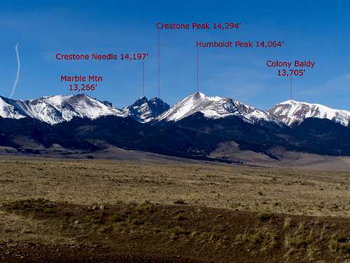
![From left to right in the...]()
Marble Mountain, Broken Hand, Kit Carson, and Humboldt | km_donovan
There is an extensive cave system on the southeast side of Marble Mountain. The book, "The Colorado Sangre de Cristo: A Complete Trail Guide", 3rd edition, 1999 by Michael O'Hanlon has more detailed directions concerning access. Here is a excerpt from the website by Wayne Anderson, Geologist, about the caves of Marble Mountain.
"Legendary Marble Cave extends several thousand feet, but only the first thirty feet are safe for amateurs to explore. Lloyd Parris in "Caves of Colorado" notes that Marble Cave has also been referred to as Spanish Cave, La Caverna del Oro, and Marble Mountain Cave.
Marble Cave and the other caves of the area formed where slightly acidic groundwater slowly dissolved limestone bedrock along joints and fractures. This dissolution produced tube-like passages that rarely exceed 15 feet in diameter. Only a few large rooms are known in the caves of the Marble Mountain area. However, deep, narrow, canyon-like features have been discovered, and some of these so-called canyons are at least 100 feet deep. Parris reports that Marble Cave, with over 3,500 feet of passageways and approximately 700 feet of relief, is probably one of the deepest caves in the nation. It contains many unexplored areas.
Exploration of the inner reaches of Marble Cave should be left to experienced spelunkers. Rope work is required and investigators must be able to "chimney" up or down vertical chasms for extended periods of time. According to Parris, Marble Cave is the longest and most dangerous cave on Marble Mountain." (Quoted with permission from Wayne Anderson, Geologist)
For the complete report on the Marble Mountain Caves, I invite you to click on the link to The Caves of Marble Mountain.
Geology of Marble Mountain and the Sangres
Comprehensive geological history of the Sangre de Cristo range by geologist Wayne Anderson.
Thanks to Wayne Anderson for all the help and for the use of his information.
Getting There
A late-morning view of the east side of the Sangre de Cristos, taken from the Wet Mountain Valley. Photo by dherrera96
From Westcliffe, Colorado: Drive southwest on highway 69 about 4.5 miles to Colfax Lane (CO119) where there is a Forest Service sign. Turn right (south) and go another 5.5 miles until the road ends, then turn right (going west) on South Colony Road (Forest Service Road 120) for 1.5 miles where there is a fairly large parking lot on the right. 2WD vehicles should park here. The next three miles are a 4WD road (FR120). This road has been improved within the last year and is much easier to negotiate than previous years. A sturdy 2-wheel drive SUV should be able to make it past the lower parking area to the TH. After three miles up South Colony road, a sign will greet you which indicates the Rainbow Trail. Minimal parking is available at the trailhead, but please do not block the road.
Once at the Rainbow Trailhead, head south and follow the Northeast Ridge Route.
Red Tape
Marble Mountain with South Colony Lake in the foreground.
Marble Mountain is located in the San Isabel National Forest inside the Sangre de Cristo Wilderness Area. No permits are required. Although the entire range and the mountain are in the wilderness area, the 4WD forest service road (FR120) is not. The Forest Service has created a three mile narrow corridor through the wilderness area to access the trailhead by vehicle. Rangers make daily drives up the road.
San Isabel National Forest, San Carlos Ranger District, 3170 E. Main, Canon City, CO 81212. Phone: (719) 269-8500, Fax: (719) 269-8719. Westcliffe has a small one-man ranger station: (719) 783-2079. The local ranger is currently Jeff Outhier.
Private Property (South Colony Road): For 1.5 miles from the 2WD parking lot to the Forest Service boundary is private property. The fences along the road are posted so please respect the signs and do not trespass.
When to Climb | Weather and Seasons
 Click for weather forecast |
As with most Colorado high peaks, late June through mid September are best for summer season climbs. However, the mountain is also an excellent winter destination due to the low avalanche danger on the northeast ridge in stable conditions. September can be a wonderful time to climb. The weather settles as fall high pressure systems move through and provide several continuous days of cool, clear skies. Violent afternoon thunderstorms are a daily occurance. Regardless of the time of year, start very early. Storms typically hit early afternoon and can last until after dark. |  Click for weather forecast |
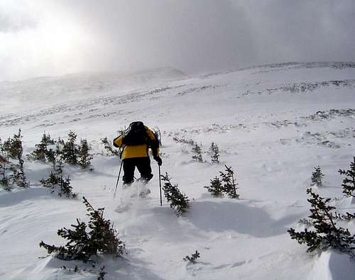 Alan sets off from timberline toward the summit Nov 2004 Alan sets off from timberline toward the summit Nov 2004 |
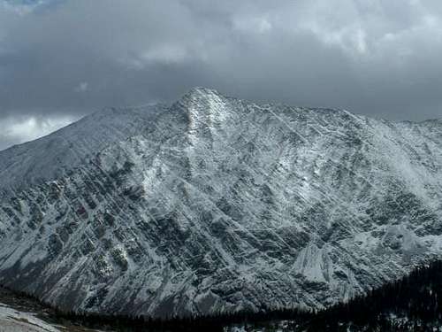
 2/11/06: Late afternoon sun on Marble Mountain from our camp at 11,800 in South Colony Lakes basin. 2/11/06: Late afternoon sun on Marble Mountain from our camp at 11,800 in South Colony Lakes basin. |
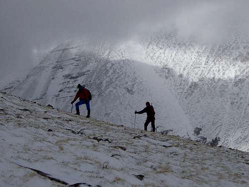 Barry and Andy on the northeast ridge above treeline. Humboldt Peak in the background.November 11, 2004. Photo by Alan Ellis. Barry and Andy on the northeast ridge above treeline. Humboldt Peak in the background.November 11, 2004. Photo by Alan Ellis. |
Camping
View of Marble Mountain from below the South Colony Lakes. Photo by Brad Snider
If climbing the mountain via Point 12,739: "There is plenty of good camping along the Music Pass road, from the horse camp and beyond. If you backpack into the Sand Creek area, many wonderful camping areas are available, particularly at Lower and Upper Sand Creek Lakes." (Courtesy of Aaron Johnson)
There are several Forest Service campgrounds near either trailhead. The closest is Alvarado, located on CO140, 5 miles west of highway 69, and one mile north of the Colfax Lane turnoff. Alvarado has 47 sites and can accommodate up to a 35 foot RV (no hookups). Alvarado is at 9000 ft which is a good place to spend the night and acclimate. Alvarado campground host: (719) 489-2744. There are other Forest Service campgrounds in the area. None have showers but most have rest rooms and drinking water. Call the Forest Service at (719) 269-8500 or (719) 783-2079 for more information on other FS campgrounds nearby.
Grape Creek RV Park: 2 miles south of Westcliffe. (719) 783-2588.
Eberling Mobile Home and RV Park: In Silvercliff on the east side of Westcliffe. (719) 783-9778. Coin operated showers and laundromat.
The Caves of Marble Mountain
Marble Mountain, Broken Hand, Kit Carson, and Humboldt | km_donovan
"Legendary Marble Cave extends several thousand feet, but only the first thirty feet are safe for amateurs to explore. Lloyd Parris in "Caves of Colorado" notes that Marble Cave has also been referred to as Spanish Cave, La Caverna del Oro, and Marble Mountain Cave.
Marble Cave and the other caves of the area formed where slightly acidic groundwater slowly dissolved limestone bedrock along joints and fractures. This dissolution produced tube-like passages that rarely exceed 15 feet in diameter. Only a few large rooms are known in the caves of the Marble Mountain area. However, deep, narrow, canyon-like features have been discovered, and some of these so-called canyons are at least 100 feet deep. Parris reports that Marble Cave, with over 3,500 feet of passageways and approximately 700 feet of relief, is probably one of the deepest caves in the nation. It contains many unexplored areas.
Exploration of the inner reaches of Marble Cave should be left to experienced spelunkers. Rope work is required and investigators must be able to "chimney" up or down vertical chasms for extended periods of time. According to Parris, Marble Cave is the longest and most dangerous cave on Marble Mountain." (Quoted with permission from Wayne Anderson, Geologist)
For the complete report on the Marble Mountain Caves, I invite you to click on the link to The Caves of Marble Mountain.
Geology of Marble Mountain and the Sangres
Comprehensive geological history of the Sangre de Cristo range by geologist Wayne Anderson.
Thanks to Wayne Anderson for all the help and for the use of his information.