

|
|
Mountain/Rock |
|---|---|
|
|
47.60000°N / 24.63000°E |
|
|
Maramures |
|
|
Hiking |
|
|
Spring, Summer, Fall |
|
|
7555 ft / 2303 m |
|
|
Overview
 Vârful Pietrosul Rodnei -
  Nagy-Pietrosz
 Pietrosul viewed from the Iezer cirque
Pietrosul (or Pietrosu) is the highest peak of Rodnei Mountains, and also the highest point of the Carpathians' curve in between the High Tatras and Bucegi Mountains.
The mountain's name means "rocky" (Romanian), which refers to its different character from most of the other, predominantly grass-covered peaks of Rodnei Mountains (only the few highest ones have rocky tops and faces, Pietrosul being the most prevalent among them). However, as many peaks of the Transylvanian Carpathians bear the same name, the peak is often regarded as "Pietrosul Rodnei" to be distinguished from the rest. In Hungarian, the name "Nagy-Pietrosz" (Big Pietros) is the most widely used, but "Köves-havas" (Rocky Alp) is also known.
Pietrosul is located in the northwestern part of the range, as the ending bastion of a bold side-ridge, which departs the main ridge towards the north. The mountain's northern slopes (three separate glacial cirques) are quite steep: there is 1650 m altitude difference between the peak and the Vişeu /Visó, Wishau/ river valley below it.
The view from the summit is quite interesting in good weather conditions. The whole range of Maramureş Mountains /Máramarosi-havasok/ can be observed towards the north (continuing in Ukraine's territory). You can see the neighbouring Ţibleş Mountains /Cibles/ to the west, and the rest of Rodnei Mountains to the east and south. In southeastern direction you'll notice Bârgău Mountains (Borgói-hegység) and Călimani Mountains (Kelemen-havasok).
As far as I know, the first recorded ascent of the peak dates back to August 1796 (Pál Kitaibel, Ádám Waldstein and János Schütz with local guides), but it is probable that local sheperds visited the mountain earlier.
Getting There
The most common starting point for visiting Pietrosul is the town of Borşa, located in the Vişeu valley, in Maramureş county. Directions for getting there and additional information are supplied on the Buhăescu page in detail.
Routes
 The beginning
 Passing the houses of Borşa
 Entering the forest
 The meteo station
 Looking back on Iezer lake
 Rising higher and higher
 Reaching the ridge
 The final section
 The impressive north face of Pietrosul in spring
There are two possibilities to approach the summit of Pietrosul on marked trails (neither of them requires any climbing, so comfortable hiking boots and typical mountain equipment should be enough outside the winter season):
1) Starting from Borşa /Borsa/, following the blue stripe:
Blue stripe starts east from the center of Borşa town, behind the hospital. Crossing the Vişeu river, the mark leads on unpaved streets with houses on both sides. After a while, the houses get more and more spaced from each other, gradually disappearing. Instead you will find a growing number of shepherd shelters along the cart road the trail follows.
Further up on the slope you will find a lot of raspberry and bluberry along the road (depending on the time of year, of course). The best tasting raspberries I have eaten in my life so far! Beware, picking the berries can slow down your pace considerably. Bears also love it, bear this in mind (on the other hand, normally they try to avoid meeting humans if they hear them coming, so talking is generally considered as good "self-defence").
Leaving the raspberry fields, the road will keep winding between pinewoods. After you get out from the forest, you will have a nice view over the Maramureş Mountains /Máramarosi-havasok/. From here, there is not much ascent left to reach the glacial cirque where the meteo station (1760 m) is situated (cart road ends). If you plan to stay for more days (which is advised), there is a designated campsite south from the meteo station houses, by the side of the little creek (Pietroasa creek) that originates from Lake Iezer /Lacul Iezer, Mosolygó-tó/ a little bit further up. The meteo station itself is surrounded by a fence and it depends on the mood of the personnel whether they welcome you in their "territory" or not (by default it's better to just walk by).
The trail continues along the creek and passes by Lake Iezer. On the 13th January, 1944, a group of 16 young Hungarian men from Salgótarján were hit here by an avalanche - only one of them survived. A memorial was erected in 2003 by the lake to remember the victims. Another memorial by the lakeshore remembers Rodrigo Nemeş, who also got caught by an avalanche.
Soon after the memorial, the trail starts winding up the steep northeast face of Pietrosu. When you reach the saddle, the path bifurcates in two directions (both marked by blue stripe). The one to the south continues towards Buhăescu Mare (dropping down to Curmătura Pietrosului saddle, with the Buhăescu Lakes below to the east). The branch to the west is a short side-trail, leading up to the summit of Pietrosu. From here it is about 10 min to the summit. The whole ascent from Borşa takes about 6 hours.
 Transect of the normal route from Borşa
2) By leaving the main ridge trail at Vf. Rebra on blue stripe northwards:
a) approaching from the west:
Shortly after Tarniţa Bătrânei saddle, the red stripe trail divides into two: one (well marked variant) leads straight to Tarniţa La Cruce saddle, the second (badly marked) variant follows the main ridge. Choose the second one and through Vf. Gropilor (2063 m) get to Vf. Rebra (2119 m). There starts the blue stripe trail towards Borşa town. Follow it through Vf. Buhăescu Mare (2268 m) until the bifurcation, where the side-branch of blue stripe leaves for the summit.
b) approaching from the east:
In Tarniţa La Cruce saddle choose the red stripe variant following main ridge, which leads up to Vf. Rebra (2119 m). Then use the description in the a) section.
 Panoramic summer view towards the east from the summit
Red Tape
 Alpine bellflowers
Pietrosul and its vicinity are part of Munţii Rodnei National Park (see External Links section), and more specifically, Reservaţia Pietrosul Rodnei. Latter is part of UNESCO world biosphere reserves. The rocky terrain of Pietrosu serves precious habitat for the Carpathian chamois.
There is no entry fee, but please respect the mountains by taking your garbage back down with you. Also, if you are descending towards Borşa and have an extra bag, you might do some voluntary service by taking trash left behind by others at the refuge on Pietrosu or the meteo station campsite.
When To Climb - Mountain Rescue
 Winter climb of Pietrosul is rather hazardous...
Though the mountain can be climbed all year, in winter there is usually severe avalanche danger on the steeper slopes (in Pietrosul's case, north). Several lives have been claimed so far, so take the warning serious! There is no avalanche forecast service.
Phone numbers for Salvamont (Romanian mountain rescue service):
- National Salvamont dispatcher: 0-SALVAMONT (0725826668)
See also the Mountain Conditions and Mountain Rescue sections of Rodnei Mountains parent page.
Camping
There are no huts in the higher parts of the mountain, so bring a tent, if you are planning more than a single-day trip. Since the Rodna National Park was created, free camping in the vicinity of Pietrosul is permitted only:
- by the Iezer meteo station (under the north face of Pietrosul)
- by Rebra lake (just below Buhăescu, near Tarniţa La Cruce saddle)
Tourists are generally not welcome inside the territory of the meteo station (fence), but in case of emergency it is possible to sleep in the small building. You will also notice a nice yellow wooden shelter by the meteo station. This building is not intended for tourists, it's reserved for the researchers of the Rodna National Park.
There is a small building (in bad shape) on the summit, which could be used as an emergency shelter. However, in practice it's rather used as a garbage store...
There are further accomodation possibilities (hotels, pensions) in and around Borşa town.
 meteo station campsite meteo station campsite |
 summit shelter ruin summit shelter ruin |
 not for hikers not for hikers |
Weather Conditions
Below you can find a weather forecast for Pietrosul by viewweather.com:
Actually, the data of the meteo station is available online here (on the right side of the page, under "IEZER"). This is the direct situation under Pietrosul.
Maps
Paper maps
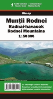
Munţii Rodnei/Radnai-havasok/Rodnei Mountains (1:50,000) by Dimap, with guiding text on the backside in English, Romanian and Hungarian. Can be ordered online directly from Dimap.
Munţii Rodnei/Rodnei Mountains (1:50,000) by Bel Alpin, with guide. Can be ordered online here for £8.00.
Online maps
A powerful free online map is being developed by the Open Maps Project for the area of Central Europe. If you are not familiar with the area or want to skip the zooming job, you can get a quick close-up view of Pietrosul's area by following this permalink.
Miscellaneous
Name
For a few years in the 2nd World War, while the Kingdom of Hungary regained rule over the northern part of Transylvania (1940-1944), Pietrosul became the highest point of the country. Driven purely by political motivation, the peak was "officially" renamed after the contemporary governor of Hungary (Horthy). After the end of the war northern Transylvania became part of Romania again, and Pietrosul got back its proper traditional name.
Sights in town
You can visit wooden church in Borşa town built in 1718 and painted in 1765 by Zaharia Zugravu (info by wolf2001).
General
For further useful travel information about Romania, check out this page.
External Links
Panorama from Pietrosu (view on Borşa until 0:15, meteo station at 0:20, Vf. Buhăescu Mare at 0:40)
Homepage of the Rodnei Mountains National Park (in Romanian only)
Munţii Rodnei page on carpati.org:
only in Romanian, but with good huts ("Cazare") and trails ("Trasee") info, plus an extensive photo gallery ("Fotografii")
Munţii Rodnei page on alpinet.org:
only in Romanian, but has news section ("Ştiri"), topo map (with a list of GPS coordinates - "Puncte GPS asociate") and some huts info
Pietrosul on Peter Budai's Rodnei Mountains website (in Hungarian)
Eric Visentin's Pietrosul page
Train search: DB search engine