
-
 98745 Hits
-
 95.35% Score
-
 52 Votes
|
|
Mountain/Rock |
|---|---|
|
|
43.12470°N / 109.6179°W |
|
|
Mountaineering |
|
|
Spring, Summer, Fall |
|
|
13745 ft / 4189 m |
|
|
Overview
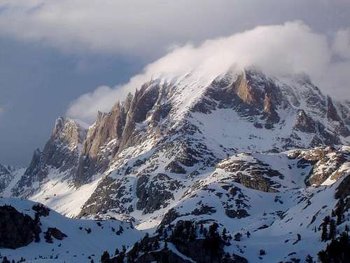
Fremont Peak is the second highest mountain in the Wind River Range and the third highest in Wyoming (See the WY 13ers list here). Barely visible from the plains to the east, it is highly dominant from the west where it appears to be the range highpoint. A Continental Divide summit, its most popular route is a steep scramble reached from the most popular trailhead in the range, normally in a multi-day trip. Fremont also provides multi-pitch (to Grade IV) technical routes on the high-quality gneiss of the massive south and west faces. The north face has alpine routes and is filled almost to the brim with one of the largest glaciers in the American Rockies. A straight snow couloir on the southeast face makes the peak indentifiable from points 30 miles down range and, in fact, the peak is also apparent from peaks in other Wyoming ranges. Its history goes back to 1842 when it was climbed by John C. Frémont. Its status as the highest peak with a non-technical route makes it one of the most popular climbs in the state. It is also the dominant peak passed by mountaineers on their way to Gannett Peak. Though Devils Tower may adorn the Wyoming license plate, it's Fremont Peak that greets visitors on border signs. "Here was not the inn which awaits the tired traveler on his return from Mont Blanc" - Frémont
|

|
Getting There
Use the Elkhart Park Trailhead accessed from Pinedale on the west side of the range and hike the Pole Creek Trail to Island Lake, passing by Photographers Point and Seneca Lake along the way. Just after passing over a small divide at 10,660 feet Island Lake will come into view. Descend to it and continue to the junction with the Titcomb and Indian Basin trails. Take the Indian Basin Trail heading east/rightward and hike to the Indian Lakes where great camping can be had. This all trail approach is somewhere between 15-17 miles long.
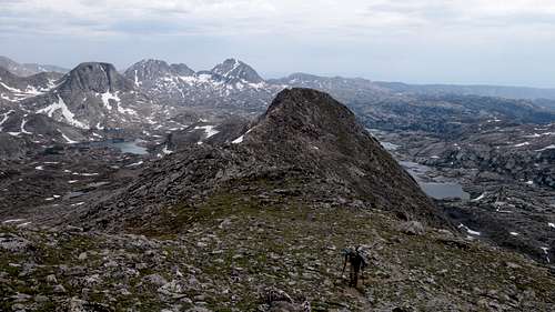
Standard Route - Southwest Slope/Buttress Class 3
Fremont Peak has a definite standard route, which is used by virtually 100% of people who reach its summit. However there are 13 other routes briefly described in Kelsey's guidebook, many of which are very high quality technical rock climbs. Others, such as the prominently visible from south of Pinedale Five Finger couloir on the SE aspect, offer a superb earlier season snow climb up to 45 degrees in steepness. I recommend checking out the guidebook if you're looking for some more challenging endevours, and if you have climbed one of the non standard routes feel free to add beta by posting a route page.
From Indian Basin, where the trail curves back to the east to begin the final ascent to Indian Pass, leave the trail and continue northwest up gentle grassy/talus (or snow early season) slopes to a broad flat section on the ridge separating Titcomb from Indian Basin at 12180 feet. This same spot can be reached from Titcomb Basin from Mistake Lake, utilizing an obvious northwest to southeast oriented narrow ramp, however this is a steeper and somewhat less enjoyable variation.
Once on the ridge, follow paths up the clearly visible south slope, which are easily seen by brown/red colored ground where rocks have been repeatedly overturned by many feet. There are many paths to choose from none of which are very good, and separated from occational short class 3 rock steps). Up to an elevation of 13,200 feet the route is very obvious. Above 13,200 feet there is a steep rock rib jutting in the middle of the slope that you'll need to keep to the left of as you continue scrambling slightly more sustained class 3 until you hit the summit ridge.
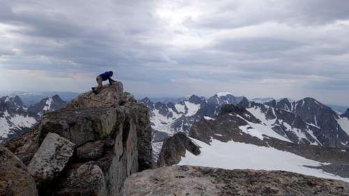
On the summit ridge, walk left or right a few feet depending where you reached it to the highest rock, bypassing any very large boulders on the ridge just on the south side. The drop down the north face is larger than it used to be long ago, as the glacier is melting quickly. Reports from early ascents indicated the glacier surface was not a large distance below the summit, however today it's obvious the drop is substantial.
|
|
Bob Sihler has also made a good route page here on SP for this route, which can be seen here.
Seasonal Conditions
Summer season in the Wind Rivers is generally July-September with snow lingering on the higher trails into July. A snow storm is traditional between the last week of August and the second week of September. This is often followed by a dry period with crisp temperatures for 1-4 weeks. On glacier routes crevasses are hidden in June and begin opening sometime in July. As the only high trailhead in the range serviced by a paved road, spring trips from Elkhart Park are common. The road is plowed to within about 2.5 miles of its end in the winter - about 2 miles past the turnoff to White Pine. Wet years, the approach is heavy with mosquitos and gnats in June and July. An area webcam depicts current conditions.
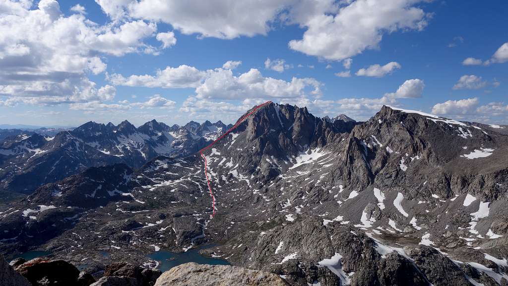
Map
The map above shows the normal south slopes route up Fremont Peak via the orange line from the Indian/Titcomb Trail junction. The line also shows a big loop I did which encompasses Knife Point mountain, Bete Noire and Jackson.
Regulations and Specifics
The west side is managed by the Bridger Wilderness and National Forest. The east side is managed by the Fitzpatrick Wilderness of Shoshone National Forest. Wilderness regulations apply for camp locations, group size, campfire restrictions and ethics. There are no permit requirements in these two wildernesses. There are some bear requirements for food storage. Though grizzlies have re-migrated to this part of the range, they are not known to frequent this approach. Minimum-impact camping and travel ethics are increasingly important at Seneca and Titcomb Lakes. Backpacking stoves are required and most climbers filter or treat their water. A fee-based campground exists at the trailhead.
History and Trivia
In 1842, Lieutenant John Charles Frémont was sent west as the commander of a government research team to survey the Oregon Trail and write a detailed report. After crossing the Continental Divide with his soldiers and famed mountain man Kit Carson, the party set out to climb what was then considered the "loftiest" peak of the Rocky Mountain chains (although the Southern Rockies have over 100 higher peaks and Gannett, the highest in the Central Rockies, is a mere 6 miles north, standing on the plains to the west, or down range, it's easy to see why this peak was chosen). Taking several days to summit, according to the journal of pioneering western cartographer Charles Preuss, many of the men exhibited signs of what we now know as altitude sickness.
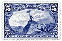
Frémont's explorations of the west continued including the "discovery" of Lake Tahoe. After promotions in rank he entered political life eventually campaigning for President of the United States as the first candidate of the brand new Republican party using his nickname "The Pathfinder". Frémont's climb is considered by many to be the first ascent of a major peak in Wyoming (Pikes Peak Colorado turned out to be a few hundred feet higher and had been climbed by an expedition 22 years prior). Frémonts topographic map, when published, proudly marked Frémont Peak as the dominant point of the Rocky Mountains, giving the peak a prominent place in American culture for many decades. His name remains on a multitude of land and political features throughout the western states. The fame of Frémont Peak attracted artist Alfred Jacob Miller and Scottish explorer William Drummond Stewart, in 1837, who made it as far as Island Lake. Frémont Peak was ascended a second time, long before other major Wyoming peaks attracted any mountaineering attention, on August 7, 1878 by A.D WIlson, William Henry Jackson, Wm H Holmes, Ferdinand Vandiveer Hayden, AC Ladd, Cliff Richardson, James Eccles, and Michel Payot. The third ascent was by Harold and Charles Titcomb, 28Jul1901.
The adjacent valley is thus named for the mountaineering brothers. "We had climbed the loftiest peak of the Rocky Mountains and looked down upon the snow a thousand feet below, and, standing where no human foot had stood before, felt the exultation of first explorers" - John Charles Frémont; report to U.S. Congress "I had imagined the Rocky Mountains entirely different, namely as a divide between eastern and western America - but these are individual mountain ranges seperated by plateaus fifty to one hundred miles wide" - Charles Preuss One of 19th century western landscape painter Albert Bierstadt's best works is his painting of Fremont Peak which hangs prominently in the Metropolitan, New York City (see image below).
 |
 |
 |
 |
**Special thanks to longtime inactive member Jimmyjay for the above information.
External Links
My Trip Report of Fremont Peak, and all the other 13ers in the Wind Rivers