

|
|
Mountain/Rock |
|---|---|
|
|
14.79000°N / 91.655°W |
|
|
Hiking |
|
|
9514 ft / 2900 m |
|
|
Overview
Although not as tall as its neighbors Siete Orejas (11,056 ft) or Santa Maria (12,375 ft), Volcán Chicabal is a well-known tourist destination in the Western Highlands of Guatemala. The volcano has a unique crater lake inside of its summit cone with a surface altitude of 8,898 feet. On clear mornings it is possible to see the major volcanoes of northwestern Guatemala as well as the Pacific coast. The crater rim and volcanic cone are covered in a lush cloud forest, and the lower slopes of the volcano are used for agricultural purposes by the locals. This easy day-hike provides a perfect mix of tranquility, culture, and natural beauty.
Laguna Chicabal is still revered as sacred by the local Mayan population. Sacerdotes (Mayan priests) commonly practice rituals and ceremonies on the shores of the lake, their festivals culminating annually in the Pedida Por La Lluvia 40 days after Easter (see description below). One could easily begin the day in Xela, get to the lake, and make it back to Xela later that day. Bungalows and lakeside camping sites also exist.
General Information for Guatemalan Volcanoes
INGUAT Page on Chicabal (Also available in Spanish)
 |
 |
Getting There
Access to Chicabal is from the highway running between Xela (Quetzaltenango) in the highlands and Coatepeque on the coastal plain. Chicabal is located in the jurisdiction of a Mayan town called San Martín Sacatepéquez.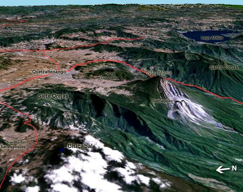
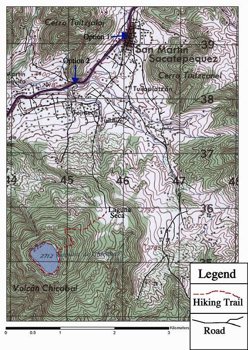
There are two options for accessing the Laguna Seca, the starting point for the crater. Option 1 begins from San Martín and wanders through several small neighborhoods before heading up the slopes of the volcano. This allows you to see the center of San Martín, one of the last places in Guatemala where some men still wear traje (handwoven traditional clothing - see photos). Option 2 begins outside of town, cutting off some of the walk and the cultural aspects of the hike. If you chose option 2 make sure you have enough water for the day.
Option 1
The locals' starting point for the volcano is accessed from the municipality of San Martin Sacatepéquez (a 40 minute Q5 micro ride from Xela or a 15 minute Q4 rise from San Juan Ostuncalco).
The walk to the Laguna Seca is approximately 1.5 - 2 hours from the center of town. Don't be afraid to ask locals about which roads to take. Several nonsensical curving streets exist to confuse visitors. There are also several signs that help guide the way. When in doubt, head uphill! Please do not give any of the local kids money, no matter how cute and poor they look. Several local children have a very paternalistic view of Westerns thanks to this bad habit.
Option 2
For those using the bus system, the Xelaju line runs between Xela and Coatepeque constantly until dark. Mention your stop as Chicabal often enough and the driver will drop you off there. The drop-off spot is about a mile downhill from San Martin. It is marked with a sign and is a well known local landmark. Take the road on your left and head uphill until you have reached the Laguna Seca, where you pay the entrance fee. From the highway the walk is approximately 1.5 hours to the Laguna Seca.
Alternatively, from the highway any of the residents nearby that have a pickup will be willing to give you a ride to the Laguna Seca for about Q20-50. Having them wait for you and give you a ride back to the highway will be quite a bit extra.
From The Laguna Seca
Either option you chose, the walk from the Laguna Seca to the Miradores (viewpoints) is about 45 minutes. If you get started early and the day is clear you will be able to see all of the big Guatemalan volcanoes as well as the crater lake to the west and Santa Maria and Santiaguito to the east. Santiaguito destroyed San Martín when it initially erupted in October of 1902. From the viewpoint, walk down the 600 steps to the lake’s shore. A beautiful and quiet trail circumnavigates the lake.
 |  |  |  |
San Martín Sacatepéquez information
Red Tape, Camping, and Fees
Aside from international travel regulations, there are entrance and parking fees at the entrance to the area. Laguna Chicabal is protected for cultural, spiritual, and natural reasons by a local organization of subsistence farmers, ASECO. All of the meager entrance fees goes to the local people. The association is slowly learning about eco-tourism. Please be patient with the locals.| Entrance Fees: Children Locals National Visitors International Visitors Parking Camping | Q 1.00 1.00 5.00 25.00 Q 10.00 20.00 |
You can camp in the Laguna Seca or on the shore of the Lake for Q20. There are also bungalows that you can rent in the Laguna Seca. The price basically depends on how much the guards want to charge you.

Mountain Conditions, When To Climb
The rainy season in Guatemala lasts from May through October. This part of Central America is one of the wettest in North America and rainfall during this six month period is anywhere between 150 and 200 inches. Most mornings are clear and free of rain, although they are still cold and humid. As the day goes on, the mountains can get cloudy before noon any time of year, and the rainy season can provide heavy tropical downpours in the afternoon. Because of its mid-altitude, this mountain is almost always caught in orographic clouds and good views are hard to come by other than in the morning, similar to most other mountains in this region.Precipitation information from the Geography Network
- Precipitation Map
