
-
 19955 Hits
-
 91.75% Score
-
 36 Votes
|
|
Mountain/Rock |
|---|---|
|
|
46.60370°N / 13.67050°E |
|
|
Hiking, Mountaineering, Skiing |
|
|
Spring, Summer, Fall, Winter |
|
|
7106 ft / 2166 m |
|
|
What's New On This Page?
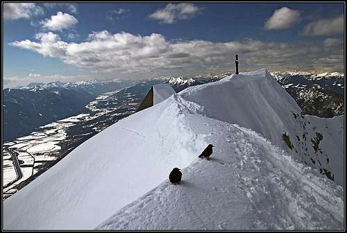 The summit of Dobrač
 The summit church
> Nov 9th, 2022 - NW route description added.
> Aug 1st, 2016 - North route added.
> Nov 24th, 2010 - Main routes more in detail described.
> Mar 21st, 2010 - Images attached and embedded.
> Dec 20th, 2004 - Gailtal Alps GROUP page linked.
> Dec 15th, 2004 - Annotations of SP-ers included.
> Dec 14th, 2004 - Initial setup of the page.
Overview
 Dobratsch from south. Red walls are, where the huge landslide went down in 1348.
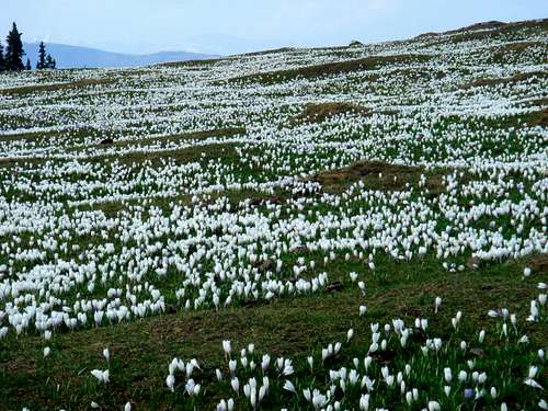
Even if I wrote only the German version, the origin of the name is Slovenian (and is written as Dobrač - with a caron above c). It would mean a good mountain (dober=good), or, the name could also originate in the word dob (=oak). And, regarding the name, one more point is worth to mention. The mountain is also called 'Villacher Alpe', so, Alps above Villach town. The broad upper area is also a pasture a big alpine meadow, that's where the origin of this name is. You will find Villacher Alpe also on many road signs.
 From the SW
Dobratsch is a 17 km long and 6 km wide massive mountain, which on the east nicely concludes the long range of Gailtal Alps. Because of the variety of possibilities it offers, the whole massif, and the highest peak especially, is very often visited. The access is easy and the panorama from the summit immense. On a beautiful day, you have a feeling, that just everybody is heading up to Dobratsch. The last time, on December 12th, 2004, on the eastern slopes of the summit you could meet hundreds of hikers, skiers, adults and children with sledges, yes, by a snowy (on a few places even icy) path even a mountain biker was pushing his tool upwards. In summer and autumn it would be the same, although when free of snow, also the steep real mountain routes are getting attendance. If enough snow, and good conditions, towards north also some more demanding ski tours could be done.
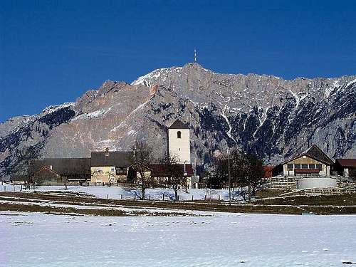
On Dobratsch 'modern times' began in 1961, when the road up was made. In 1971 followed equipments for transmitting radio and TV program across the whole Carintia. A 165 m high tower is standing just below the summit. Dobratsch is also an important place for weather observing. Measurements have started already in 1876 - on the web you can find data under 'Villacher Alm'. On the very summit two small churches stand - the German and Slovenian one.
On the east, Dobratsch rises up directly from Villach (58.000 inhabitants), where Gail/Zilja river flows into Drau/Drava. Eastern slopes are rising steadily, here the mountain is broad and above the forest boundary also plateau-like. The most impressive side is the southern one, where the whole massif is falling with steep rocky walls and gravel slopes towards Gail/Zilja river. In 1348 a big part of this slope went down into the valley as a big landslide, causing a major catastrophy. The northern border is a valley where Bad Bleiberg stands. In past this was a mining resort (lead and zinc), now the valley is living more of tourism - also mine caves are prepared for a massive tourism. One of the two creeks, sourcing near Bad Bleiberg, is flowing towards the west and around the Dobratsch massif, so forming its western border. Northern slopes of the massif are covered with forests and are on the western part steep and also rocky. Similar is also the western side of massif.
Summit View
 Karawanken/Karavanke
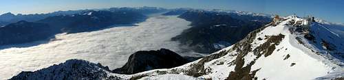 Herb - Summit panorame
The first reason why to ascend Dobratsch, would probably be to enjoy the broad panorama. In any time of the season. Although lying behind Carnic Alps and Karavanke, the wild Julian Alps are from nowhere seen so completely and clearly. Karavanke range can be seen entirely, far on the east also the higher Kamnik Alps peek out of them. Towards the east also the broad Drava valley is impressive, especially in a clear day, when we can admire nice blue lakes in its surroundings. Far in distance there are Lavanttal Alps and towards the NE the whole hilly Gurktal Group. Across the Drau valley especially Nockberge are clearly seen. Between Lavanttal Alps and Gurktal Alps the Eisenerz Group is seen and some summits of Niedere Tauern. Towards the north the whole horizon is boiling. High, sharp peaks of Hohe Tauern are clearly distinguished. Behind Katschberg Pass we see first Radstaedter Tauern (belonging to Niedere Tauern), then Ankogel Group with the princess Hochalmspitze, then Goldberg Group and finally the highest peaks around Grossglkockner. Fascinating is also the view towards the west. First our view follows the long range of Gailtal Alps. Nice are the fist high mountains above Weissensee, then Reisskofel and in distance Lienz Dolomites. The valley of Gail/Zilja is seen far towards the west, until it is squeezed by Lienz Dolomites and Carnic Alps. Also the main crest of Carnic Alps is seen almost till its western end and all the main summits can be distinguished.
 Julian Alps Julian Alps |
 The highest church The highest church |
 Carnic Alps and Gailtal Carnic Alps and Gailtal |

|
 Click to run this one online |
What To Do Up There?
In the first place Dobratsch is a hiking mountain. You can do hikes from 500 m to 1600 m of altitude difference. From the easiest, with hands in pockets, to steep and also exposed paths. A suitable crag for climbing is found above the Hunters path, below the summit of Zehnernock, not far away from the upper parking place. The crag is south oriented. In summer and autumn, mountain biking is also a nice option. To do a tour from Villach to the summit, means 1600 m of a hill upwards and the same difference down.
 Summit ski slopes
In winter and spring skiing is very fine on Dobratsch. From west of Heiligengeist to the altitude of some 1550 m there was once an ordinary ski resort (but because of water sources protection, all ski lifts were uninstalled and today there's only a natural parc), the whole this slope and the rest to the summit is very fine for tour skiing. Easy and long. More direct skiing towards Bad Bleiberg is much steeper and harder. It can be done only in good conditions.
 Cross country ski tracks
On Rosstratte, where the upper parking place is, over the summit plateau nice cross country ski tracks are usually prepared. With cross coutry skis you can extend the run also to the very summit of Dobratsch (by the road).
 The summit road
When weather is for a longer time cold and stable, the upper 600 m of the ordinary path is prepared also to be used with sledges. Very joyful for the youngest! And what to do below? It's worth mentioning the wide known spa (already ancient Romans used hot water sources). Today, mountain sources are able to give 40 million liters of water per day.
The Landslide
 The southern face - after centuries landslide wounds are still seen
In January 1348 a strong earthquake (estimated around 6.5 on Richter scale, with epicentre in Furlania) caused a great landslide of Dobratsch south slopes. Huge stone masses, thousands tons of rocks, mixed with snow, covered 17 villages in the valley of Gail/Zilja. Still today the landslide place can be seen as the breathtaking Rote Wand (Red Wall). In the valley two villages are still today called Schuett (which would mean 'Gravel').
Gangolf Haub explains the landslide more in detail: One thing I would add: the reason for the big landslide was the tectonic movement along the Peradriatic Fault between the European and North-African tectonic plates. The fault runs directly through the Lesachtal and Gailtal Valleys and is responsible for much of the complexity of the region's mountain ranges. The Dobratsch landslide and its remains are certainly not the only proofs of the tectonic activity. Just look at the layering of Kollinkofel in the Carnic Alps or Grubenspitz / Böses Weibele in the Lienz Dolomites. Here the layers were thrown around big time. Today mountains with diagonal layers in all directions or mountains with old layers topping new layers are very common in the region.
Klaus Robl added these comments: The movements did not take place along the periadriatic lineament, otherwise the epicentre wouldn´t have been in Furlania. In recent geologic times no significant movements took place along the periadriatic lineament. Those active faults where right lateral movements take place caused by the indentation of the Adriatic microplate are situated further south in Northern Italy (area around Gemona)and as well in Sovenia (Idria-Soca Fault). Therefore the epicentres of the strong earthquakes that are related to this process can be found in these two countries. The tectonic activity that mentioned Gangolf is of course not restricted to the Carnic Alps and the Gailtal Alps. All of the Alpine orogenesis (mountain forming) is the result of complex tectonic processes related to the convergence of Africa and Europe and the subsequent closure of the Tethyan Ocean. To your really excellent description I would like to add that it is proofed now that the villages that were buried under the landslide counted less than 17. This often published number was a large exageration with the intention to receive more money.
Still, it is estimated that the great landslide of 1348 was only one in a long series. The whole area of old and new landslide masses is today covering 24 square kilometers and gravel masses are in some places up to 30 meters high. That's why this gravel is today one of the most fascinating protected areas of Nature in Europe. The first attempts to protect the area date back to 1942, in 1970 followed the protection of the rest of Dobratsch's south face. Today it is included in Europe's Natura-2000 project. The landslide area is hosting some plants and animal species, which would otherwise not be in these surroundings.
Getting There
 Rosstratte parking place
For general orientation, see the Gailtal Alps GROUP page! Villach can be reached best by the highway: Udine - Tarvisio - Villach - Spittal - Salzburg. For the broader orientation see the Eastern Alps page and the Gailtal Alps group page.
From Villach you can drive around the Dobratsch massif by good roads (see the map) and drive up also by the good and broad panoramic road till the last parking place at about 1700 m of altitude. The road must be paid in summer (in winter it is free).
Routes Overview
1. The easiest route is over the eastern slopes. Actually it's a narrow road, but closed for public traffic. In winter it's prepared to be used with skis and even sledges. From the parking place 1 h 30 min. Going up the road from Rosstratte/trata, you can prolongue the east approach if on the first curve you deter left and go by the Hunters path. It sticks to the very edge of the massif and crosses the slopes of fore-summits. The path is good, but also exposed on a few places. 2 h 30 min. Marked routes over the northern, southern and western slopes are considerably longer.
2. Southern route. From power plant near Arnoldstein, 541 m, we ascend over the whole southern face. 1625 m of ascent, a demanding, not all the time marked path which reveals the beauties and wilderness of the south face. Rarely ascended. On return we can go by the eastern path and road down to Alpengarten, 1502 m, from where the path goes down towards the south. The whole tour will take you 11-12 hours!
The other route from the south is all the time marked and goes more eastwards, coming on the upper plateau at Wabenriedel.
3. Western route. Above Hermsberg, on the altitude of 900 m a marked path starts which is shady till its upper part. It is easy, but also high (some 1270 m of altitude). Mostly it keeps left of Alplgraben, on the return, we can also visit the beautiful Alpl meadow. 4 h.
4. North-western route. The trail Bleiberg-Nötsch -> Grünnock -> Dobratsch starts on the altitude of 915 m. It is occassinally marked (on the map above drawn in black). In the lower part (just at the start) it has 2 variants, it looks that the western variant is more recommendable. It's a steep ascent, with excellent views from the summit of Grünnock and from the ridge connecting Grünnock and Dobratsch. Some exposed parts on this connecting ridge. Poles are recommended to use. In winter it can be dangerous to ascend there. Description and pictures by: SzaniUherkovich.

|

|

|
5. Northern approaches are also long. The direct one goes from Bad Bleiberg, 902 m. One marked path goes directly up by the northern slope, the other one goes much left around (eastwards, over Tratten/Trate) and is less steep. 1270 m of altitude, 3 h 30 min. Towards the east and north a fine ski tour can be done. Either only to the parking place or all the way down. If someone takes your car down to Heiligengeist, you can do from the summit of Dobratsch a whole 1400 m ski downhill by the former ski slope. It would be also fine to learn what are the possibilities for a harder ski tour towards north from the very summit of Dobratsch.
Red Tape
 Herb - On the slopes of Dobratsch
Dobratsch is today a natural parc. The road from Villach must be paid in summer and autumn.
When To Climb
Dobratsch can be ascended any time of the season. Here is the link to the Weather station Dobratsch page. The webcam on Rosstratte, 1723 m. For weather conditions for Austria see here (then choose region: Kaernten). Avalanche info page is the following: Kaernten. Here is the link to Ski info on the nature parc.
Camping
We don't need huts support to ascend Dobratsch. On the summit plateau there are many private huts and restaurants, among official huts are also: Ludwig-Walter-Haus (2143 m), Knappenhütte (1700 m), Aichingerhütte (1650 m).
Outside Links
- Villacher Alpenstrasse - The Villacher panoramic road (in German)
- Dobratsch parc of nature (in German)
- Webcam - the view along the Gailtal.
Your Help Needed
If you have it, please add the following information:
- Route description of the south ascent.
- Route description of the west ascent.
sev0r - Apr 21, 2017 7:57 am - Hasn't voted
Additional WebcamI suggest to add the "new" webcam looking from the summit over the Gailtal: link
Vid Pogachnik - Apr 21, 2017 9:57 am - Hasn't voted
Re: Additional WebcamThanks! This is done now :) Best, Vid
SzaniUherkovich - Nov 5, 2022 9:59 am - Voted 10/10
"Help needed" -->Hi Vid, you asked for "help" about the southern and western route. I can give some info and hints about the northwestern route. And I also attach four related photos about the route. So here are my notes: Trail Bleiberg-Nötsch -> Grünnock -> Dobratsch - trailhead at 915 m a.s.l. from the village Bleiberg-Nötsch - the trail is occassinally marked - steep ascent - excellent views from the peak of Grünnock and from the ridge connecting Grünnock and Dobratsch - some exposed parts of the ridge connecting Grünnock and Dobratsch - poles are recommended to use - in winter it can be dangerous to ascend here Cheers, Szani
Vid Pogachnik - Nov 9, 2022 12:43 am - Hasn't voted
Re: DobratschHi Szani, So nice to hear from you again and thank you for additions! I added a paragraph in the Routes Overview chapter of Dobratsch page, acknowledging you. Please have a look and tell me if you agree with the text and the 3 pictures inserted. Of course, if you decide to create an independent Route Page, it would be great. The summary on the main page can stay anyway. Especially, as on the map there are two paths going up from the valley and I still don't know which one is recommended. You can also tell me that and I will draw it on the interactive map which is on the page (it's quickly done). All the best! Vid
SzaniUherkovich - Nov 10, 2022 9:46 am - Voted 10/10
Re: DobratschHi Vid, I had a few days off last week. How is the best to spent this time? Going to the mountains! Of course I agree with your inserted text. No, I don't want to create an independent route page. From one side because I have quite limited time. From the other side because we walked only the upper part of the route. We walked a "standard" round on Dobratsch: starting from the parking lot on the plateau, Jaegersteig for ascent, and descending through Elfernock, Zwölfernock and Zehnernock. I didn't feel this round enough long, so I extended the route with a sideway from the peak of Dobratsch to Grünnock, and a bit further down. But not down to the Bleiberg-Nötsch. That would have been too much. The same day I had to drive back to Pécs. 580 km. I will send the full route map shown by Bergfex, to your gmail address. And I will add other photos to Dobratsch. And also to Rosennock (your page). Because we climbed that, too, the day before. With László, whom you met a few years ago. And I also noticed now that you have a page about Kobesnock, too. What I ascended in July. But I didn't know that it has a page (your page) already, so I will add photos there, too ;-) Cheers, Szani