
|
|
Mountain/Rock |
|---|---|
|
|
Yuma |
|
|
Hiking, Mountaineering, Scrambling |
|
|
Winter |
|
|
3156 ft / 962 m |
|
|
Overview
Sheep Mountain is the highpoint of the Gila Mountains, a rugged desert range located about ten miles east of Yuma, crossed by Interstate 8 at Telegraph Pass about 8 miles north of the summit. The Gila Mountains are located within the Barry M. Goldwater Air Force Range (BMGAFR). When viewed from certain angles, the summit of Sheep Mountain is almost indistinguishable from the rest of the range. Sheep Mountain is seldom climbed: there are no maintained trails or campgrounds in the area, and the access road is rough. Its location on the Goldwater Range also tends to discourage visitors, and the climbing season is very short as it gets very hot here in the summer, as early as March and as late as November. As a result of all these factors, few people visit this area. The summit elevation is 3,156 feet, and has a prominence of 2,326 feet, placing it 49th on the list most prominent mountains in Arizona.
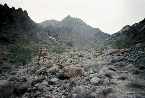 Looking into the initial canyon, by streeyyr
Getting There
Drive Interstate-8 to the Wellton exit (exit 30). Drive north about a mile into Wellton and turn left onto Old US-80, also signed as Los Angeles Avenue (A Circle-K is at the northeast corner). Follow Los Angeles Avenue for four miles until you reach Avenue 25 East. Turn south on Ave 25E, and cross over the railroad tracks and shortly, underneath I-8. Pavement ends immediately south of the interstate. A mile later, cross a canal by going left over the berm, then right down it, to get back onto the Ave 25E alignment. About another mile, come to a T-junction at the Goldwater Range boundary. This is also the intersection of Ave 25E and County 14th Street. This intersection is marked by spot elevation 402 on the topo map. Turn right and go west a little less than a mile to an intersection with a rough dirt road heading south. This intersection is marked by spot elevation 399 on the topographical map, and a post on the road should read "4" but you may need to get out to inspect it to be sure. From the intersection, head south on the rough gravel road. Drive about five miles until the road starts to enter the foothills. Come to a Y-split in the road: the "main" road stays straight, while a lesser road veers south (left), leading to an open mine. It's best to park at this Y-junction. There is room to camp, and the road to the mineshaft is very rocky. Furthermore, you want to avoid that mineshaft, especially camping near it in the dark. It's unprotected and vertical. A fall in would be fatal.
Mountain Conditions
Recreational activities are permitted on the Barry M. Goldwater Range, but you will need to obtain a free permit in advance. Contact the Range Permits Office in Yuma at 928-269-2799. In Phoenix, permits can be picked up at the BLM office in downtown. BLM, Phoenix. Topo Map: Wellton Hills.
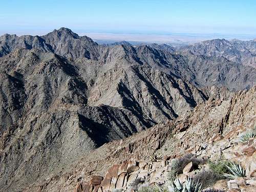
 Summit of Sheep Mountain
Camping
Camping in the range is permitted in accordance with the range regulations. Pack out all trash, leave no trace. Yuma has all sorts of hotel options. Wellton has one or two, if I recall. Wellton has the basic services as it is the largest town east of Yuma, the hub, so to speak, of the various farming communities strung out along the Gila River and Interstate-8.
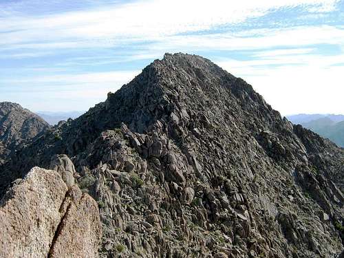
 The upper ridge
External Links
• Barry M. Goldwater Air Force Range • Highway of the Devil
Route Information
Walk the lesser track past the mine shaft and aim for the broad drainage, then veer right and drop into it when convenient. Stay in this drainage as it gently steepens, with the walls closing in. The rocks are very solid here and brush is mostly light. Some ironwoods are found in here. Follow the bends in the canyon, and after about 900 feet of gain (slightly over a mile), come to a set of tanks, a "guzzler", set up for the bighorn sheep. The saddle you want is up ahead another 600 vertical feet, and about two miles from the vehicles. The climbing to here is easy and pleasant. A few dry waterfalls up high may pose some slight challenges, but the scampering is logical and fun. At the saddle, Sheep Mountain is visible to the left, still about 700 feet above. From the saddle to the top you must contend with rocks, loose slopes, pinnacles and other barriers. However, a carefully-chosen route will never exceed Class 3, but exposure is always a factor. The first hundred or so feet upward is very easy, then you come to the first rock barriers. We generally angled right and followed chutes and angled rock slabs. BEWARE: the rock is flaky up here! Test each hold carefully. You are aiming for a "false summit", a ridgepoint at about 3,020 feet. Most likely you will approach this point from the left side of the ridge, crossing over not far below. Then there's a downclimb, perhaps the only crux part of the climb. This chute drops about 15-20 feet and is very steep and exposed. Loose crud below and a long runout demand that you be careful. Now on the ridge connecting the false summit to the real thing, you must do battle with more rock outcrops. These aren't bad, and you generally stay high and cross over them. There's a short "dull knife edge" to walk across, and another spot requiring a traverse across a foot-wide ledge with about 30 feet of drop below. After that, the summit is yours. Going down, retrace your route, and you may find chutes and other options that weren't obvious coming up. Go very slowly and deliberately up and down this ridge. You will agree it's not difficult climbing, but it is sustained, sometimes sloppy and exposed, and forces one to go slowly. The round trip hike is about 6 miles, maybe less, and about 2,300 feet of gain. Allow about 5-8 hours. December - February are the only logical times to be here. Also, the probability of meeting up with illegal border crossers here is zero. This canyon is way off any logical north-bound track they'd want to follow.
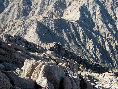 What you can expect up high
Dundeel - Mar 1, 2011 11:28 pm - Voted 10/10
Red TapeThe Yuma MCAS permit office hours are 9am to 3pm weekdays. You must pick the permit up in person.
neutscoot - Jan 19, 2021 9:25 am - Hasn't voted
Permit system has changedAs of January 2021, permits can be obtained completely online at https://luke.isportsman.net/. You must register an account and watch a 13-minute video, and then you will be issued a permit valid until the next June 30. You are supposed to print two copies -- one to leave on the dash of your vehicle, and the other to have on your person while out on foot. You must also check-in and check-out online when you plan to visit. You can check-in the day of, or the day before. The permit is valid for both the Marine Corps and Air Force sides of BMGR, as well as Cabeza Prieta NWR. If you enter Cabeza Prieta, you must stop at the refuge boundary and fill out an additional slip that asks for your iSportsman permit number, intended activities, vehicle information, and length of stay.