
-
 32891 Hits
-
 93.1% Score
-
 41 Votes
|
|
Mountain/Rock |
|---|---|
|
|
48.83650°N / 121.5864°W |
|
|
8268 ft / 2520 m |
|
|
Overview
[Author's note: More photos on the route description page.]
 (Scott Dusek photo.)
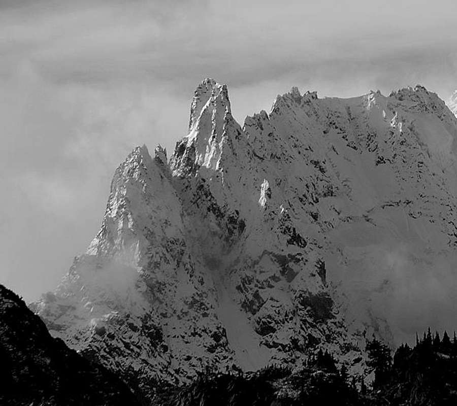
Nooksack Tower is an outlier of the Mount Shuksan massif, 0.8 mile (1.3km) NE of Shuksan's summit. Composed of the same greenschist (metamorphosed seafloor basalt) as Shuksan, it is almost impossibly steep on all sides, in spite of the friablity of the aforementioned rock. The hardest pitch of the easiest route is about 5.4 or 5.5, but reaching the summit demands a level of work, commitment, and mountaineering versatility unusual for the Lower 48 states. Climbers must be prepared for a river ford, navigating in thick forest, crevassed glacier crossing, a steep snow/ice gully, steeper, marginal-quality rock, and descent of all the above. While strong parties of two can and have been able to climb and return in a two-day weekend, our threesome was too slow and spent all Sunday night just getting back to our high camp. Since there are no easy summits or trails anywhere in the area, there's a good chance you'll have the peak and approach to yourselves. Our party saw no sign of people from the time we left the Nooksack River Trail until we reached the car again.
 |  |  |  |  |
Getting There
From Bellingham, leave Interstate 5 at the Sunset Drive/Mount Baker exit. Drive the Mount Baker Highway (Washington 542) E through the town of Glacier (last stop for groceries), and continue 13 miles (21km) to the Nooksack River bridge. Immedialtely before this bridge, turn left on the Nooksack River Road, USFS #32. In ½ mile (800m) stay left, at 1.4 miles/2.25km (from highway) stay right. Continue to washout at 2.3 miles(3.7km). Park here, at Ruth Creek, elevation 2,156 feet (657m).
Hike the abandoned road beyond the washout two miles to the Nooksack Cirque trailhead at 2,550 feet (780m). Continue up the valley, watching across the valley for the steep channel of Price Creek. Find a place to ford the Nooksack and proceed up the forested mountainside E. of the creek. Though it seems more efficient to cross the Nooksack upstream of Price Creek, it looked shallower a ways downstream. We crossed there and started up the W bank of Price Creek until we found a good log crossing. Fill water bottles at the Nooksack or Price crossing, then stay on the the crest of what develops into a minor ridge in steep forest, then moraine above Price Lake (3,911 feet/1192m). We dropped down to the lake for lunch and water, but it wasn't worth the dense willow brush over lumpy gravel to reach water thick with glacial flour.
Stay on the moraine as it rounds the N side of the lake and lower glacier. We reached water at about 5,000(?) feet (1500m), where we hit a step in the ridge with snow melt cascading down cliffs and into our bottles. A small defile provided access to the ridge above the step. At about 5,900 feet (1800m) we found enough flat rock for bivy bags, and a gentle slope leading to the Price Glacier.
Glacier crossing: In the morning we followed a more-or-less beeline for the base of our route, with deviations for crevasses. From up on the Tower, Larry noticed that there was an arc of clearer terrain closer to the ridge and mountain. We returned to camp that way (in the dark & fog), and it was an improvement. So...when first stepping out onto the glacier, head left and up, then bear right toward the Tower on clearer glacier.
 |  |  |  |  |
Red Tape
Nooksack Tower and Mount Shuksan are in North Cascades National Park. To camp in the backcountry, you'll need one Backcountry Use Permit for the party. It's free, but you must apply for it and pick it up the day of your trip. Get it at the Ranger Station in Glacier. There's a maximum party of 12 in the wilderness, but taking a large party on this route would be insane, anyway. You'll need a Northwest Forest Pass to park at the trailhead ($5 per day or $30 for all year). They're available from any US Forest Service or National Park office in the region, a few businesses, by mail, or online.
For more information in May through October, call the Wilderness Information Center in Marblemount, WA at (360) 873-4500, ext. 39.
In the off-season, check the national park and national forest combined headquarters building on Highway 20 in Sedro Woolley: 360-856-5700
When To Climb
Summer. Avalanches and lack of daylight both preach against winter and spring attempts, at least to us sane types. We tried it on the weekend of the Summer solstice for maximum daylight. The 800-foot (240m) snow gully was our main concern, and we found it as good as could be hoped: the snow wasn't completely consolidated, but sound enough. The central chute was bare ice. Glacier travel was easy (with care, of course), and the rock was bare. Even on the longest day of the year, our threesome ran out of sunshine with hours to go. Derek is working on a trip report with all the details.
It has been climbed in winter. First winter ascent team, in February, 1983, included Jim Nelson, co-author of Selected Climbs in the Cascades. Damn.
Camping
We hiked the ridgeline between the Price and East Nooksack Glaciers, up from the moraine above Price Lake, to a flat spot at about 5,900 feet (1800m). Most of it was snow-covered in late June of '81, but there was space for three bivy sacks. Finding a campfire ring here would be disgusting. Bring a stove. A nature note: Our camp was visited by a marten , one of only two I've seen in the Cascades.
Price Lake is nice to look at, but I wouldn't choose to camp there. The beach is made of rocks in the potato-to-cantaloupe size range, the lake is so full of glacial flour I wouldn't drink it, and it's too far from the climb.
 |  |  |  |  |
Mountain Conditions
The USFS Mount Shuksan climbing notes page has entries from parties returning from that climb. Their website also has trail conditions and road conditions reports. None of the travel inside the National Park is on a road or trail. The National Weather Service in Seattle has a web page for weather on the West Slopes of the Northern Cascades .
Maps and Books
USGS Quads: Mount Shuksan, WA covers almost all the trip. You'll park the car and start hiking on the Mount Larrabee, WA map and cross a scant mile of the SW corner of the Mount Sefrit, WA map.
The US Forest Service map of Mount Baker-Snoqualmie National Forest gives a very broad overview with road and trail numbers, but no contours
The free North Cascades National Park handout map gives almost no info useful for the ascent, other than the rules and regulations on the back.
Green Trails maps are excellent for hikers, covering a larger area per sheet than USGS 7.5-minute maps, but for this trip there's not much trail to follow, and I'd want all the detail I can get from the USGS maps.
Fred Beckey's CASCADE ALPINE GUIDE, Climbing and High Routes, Vol. III, Rainy Pass to Fraser River. Fred Beckey almost single-handedly opened the up the Cascades for the rest of us with his barrage of first ascents (including Nooksack Tower, in 1946) and excellent, comprehensive guidebooks.
Rescue & Stuff
911 is the phone number for any emergency service in Washington State. Good luck. Cell phones probably won't work, even from the summit. There's a cell tower at the Mount Baker Ski Area, but Mount Shuksan's in the way. Maybe you'd hit a tower above the Skagit valley, or the Frazier in Canada. As always, leave word with somebody who will notice if you don't come home. Print the route description page for them and scribble your expected return time, car and tent descriptions, etc. on the back. We were so late, friends in Skagit Mountain Rescue Unit were on the road before we could reach a phone, but they'd have been hard-pressed to help us if we really needed it. Stay safe.