
-
 9241 Hits
-
 85.36% Score
-
 20 Votes
|
|
Mountain/Rock |
|---|---|
|
|
46.87601°N / 12.34069°E |
|
|
9698 ft / 2956 m |
|
|
Overview
Geographical Classification: Eastern Alps > Hohe Tauern > Villgraten Group > Rote SpitzeRote Spitze (= Red Peak") is the second highest mountain of the Villgraten Group. It is situated along the main ridge of the group, near its neighbor of Weisse Spitze (= White Peak) that is the highest. But probably Rote Spitze does not get less visits because it has the advantage of marked routes from both sides, north and south, that means Defereggen valley and Villgraten valley.
It is funny that people from the Defereggen valley have named the two mountains just vice versa, so if you start from north you have to look for "Weisse Spitze" !!
Without doubt for geological reason Rote Spitze and Weisse Spitze have a similar construction: the west ridge offers the easy normal route while the mountain falls steeper on the eastern side. In both cases near the notch west of the mountain there is a little lake
You might consider whether it is possible to combine a trip of Rote and Weisse Spitze. I've read that this is done sometimes, but surely the difficulties exceed the ones of the normal marked routes. As the steepest part is the ridge that goes down from Rote Spitze, it is probably best to do this upwards. It is surely necessary to climb UIAA II without rope and to have a "nose" for the best route.
 |  |  |  |
Getting There

Rote Spitze is in subgroup 1, just left of the marked Weiße Spitze
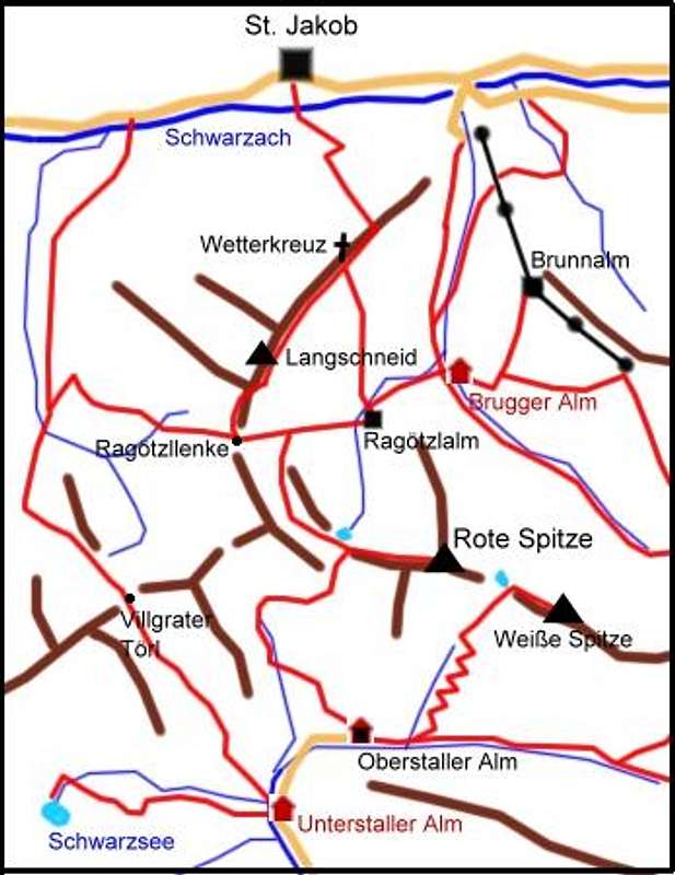
There are two trailheads for Rote Spitze, one in the south at the end of Villgraten Valley at Oberstalleralm, the other in the north in Defereggental valley at the village of St. Jakob.
For broader orientation please look at the Villgraten Group page or the page about the near Grosses Degenhorn.
 |  |  |
Routes Overview
As said above there are two trailheads and two normal routes on marked trails that only require normal hiking gear if summer conditions are good (no snow):
North route:
Starting point is the parking at Brunnalm cablecar near St. Jakob in Defereggen. Using the cablecar itself is not of much use because you would have to descend first.
Parking Brunnalm (1400 m) – Bruggeralm pasture (1818 m) - Ragoetzlalm pasture (2115 m) – Rote Spitze (2956 m):
Ascent time: 4,5 h
even nicer, but more demanding is to start at St. Jakob for the Langschneid round trip
South route:
Trailhead is the pasture village of the Oberstalleralm (1883 m), that can be reached with private car on a macadam road, free until Unterstaller Alm (1664 m) and then with a little fee.
Ascent time: 3 h
 |
Summit Views
As all higher mountains of Villgraten Group Rote Spitze is a fine lookout mountain in a perfect position between Hohe Tauern main ridge in the north and the Dolomites in the south. |  |  |  |  |
Summit View Close-Ups
 |  |  |  |  |
Langschneid (2689 m)
When doing the Langschneid round trip you gain another interesting summit, that is also a goal for its own – and not a very short one because of 1300 m ascent. This outpost and its shoulder on the NE ridge called Wetterkreuz (weather cross, 2233 m) is very near to the Defereggen valley and it is the best viewpoint down to the valley and to Rote Spitze. |  |  |  |  |
Red Tape
There is no red tape concerning climbing in the Villgraten Group.When To Climb
Depending on the amount of snow in the mountains.The hiking season runs from June to September/October - as long as there is no fresh snow. In June you surely have to cross some snow fields
An ascent with ski in spring should be possible at least on the north route if conditions are safe – but I have not read any report yet. In any case this is not a common ski touring trip.
But Langschneid can be done well with ski - see this description in german at www.tourentipp.de
Accomodation
Villgraten and Defereggen valleys are nice destination for a mountain holiday and offer many possibilities. For accommodation follow one of the following links:- Defereggental valley official site
- Hochpustertal official site
- Anras official site
- Sillian official site (click on the "Live Bilder" link for livecams and weather info).
- Außervillgraten official site
- Hochpustertal lodging (tiscover.at)
Apparently there are no official campyards in the villages near the mountain.
My recommendation for cheap lodging in St. Jakob is Barmer Haus. This is a self-service hut mostly used by families. When I was there there were always empty places in one of the 10-bed-rooms that can be used with your own sleeping bag for a rather small fee.
The north route can be started at this house.
Maps & Books
MapsCommon are the maps by Kompass Verlag, which are good for the hiking trails but not very detailed if you want to judge the terrain.
- Deferegger Alpen Lasörlinggruppe, 1:50000, WK45
ISBN: 3-85491-053-3
Better are the official Austrian Topographical Maps 1:50000, but they are difficult to obtain. The right one would be
- ÖK Nr. 178 Hopfgarten in Defereggen, edition 1992 - out of print, but maybe available in shops in the area
Books
You’ll probably not be able to find anything on the Villgraten Group in a language other than German. The book Gangolf used is
- Hiking and Trekking Osttirol Süd, W. Mair, Rother Verlag, ISBN: 3-7633-4132-3
Good descriptions with maps covering: Defregger Berge, Villgrater Berge, Carnic Alps, Lienz Dolomites