
|
|
Mountain/Rock |
|---|---|
|
|
40.27500°N / 111.9398°W |
|
|
7690 ft / 2344 m |
|
|
 Lake Mtn range as seen from the east
 Sunrise atop Lake Mtn
Overview
This is a Utah prominence peak which is why I found it worth a visit. If you are not interested in climbing prominence peaks, this peak should be considered as a premier view spot which would make it of value to visitors. The range is called the Lake Mountains due to its proximity to Utah Lake and the highest point ranks #49 on the Utah Prominence peak list. Here is a neat shot that shows Utah Lake and the Lake Mtn range as seen from high on the flanks of Mt. Timpanogos (recent Everest ridge climb)Across from the impressive Wasatch front is a tremendous viewpoint known as the Lake Mountain range. As you drive down (or up) I-15 between Provo and Orem, most of your attention is taken by the high peaks known as the Wasatch front. Mt. Timpanogos, Box Elder, Spanish Fork, Cascade and Provo Peaks present a big wall that draws your attention to them which makes it easy to overlook anything else but yet west of Utah Lake is another area that is deserving of some interest, the not so high but still worth looking at, the Lake Mtns.
Dotted along the tops of this range are numerous antenna installations, one of the sad changes wrought upon many of the mountain tops by man's quest for improved communications. Yet, when the avalanche danger is high in the Wasatch front peaks, this small range offers a chance for some great outdoor conditioning and offers a remarkable viewpoint that is well worth the effort to attain.
The highpoint of this small range is also one of Utah's prominence peaks. Coming in at #49 on the list as maintained by Peakbagger.com's list, this range's highpoint has some interest to those who are into chasing down the 80+ prominence peaks of the state of Utah. Click HERE if you'd like a little more information about what prominence is. It is also listed as one of Utah's fifty finest , information found in a book published by Andy Martin, one of the men who helped to create and establish the "county highpointing" movement that many are happily involved in. His book, "County Highpoints" is considered the 'Bible' of county highpointing as it is filled with lists not only of all the county high points, but also the 50 Finest lists wherein the top Fifty peaks that have the most prominence are listed. Scroll to the bottom of THIS page for how to order this book should you be interested.
The highest point of all is topped by a Loran station, used to help guide aircraft and is surrounded by a fence. A nearby peaklet to the south west is only a few feet lower and is an easy walk, even in the snow from the Loran topped highpoint and should be visited as well. Whether or not you decide to hop the fence to hasten to the topmost (flattened) area occupied by the Loran facility is a choice that is up to the individual but perhaps not a wise one. Still, the view from near the top suffers very little whether you attain the highest spot or not.
Getting There
From Salt Lake City or Provo, take the 279 exit off of I-15 and head west on Utah highway 73 for 6 miles going through town of Lehi. At the junction with Utah highway 68, turn south and head through the developing suburb of Saratoga Springs. The drive south will take you 5.3 miles from the junction (Redwood & highway 68) to where you should start looking for a turn off heading west. There is now a sign for Israel Canyon on the highway and a street name of Stillwater Drive. Stay on Stillwater as it curves a bit and go less than a mile and it will turn from blacktop to dirt as you exit the housing area and start the rough road that is the Israel Canyon road. A high clearance vehicle is recommended and you might work your way up another 1.3 miles to where a large area is on the left side of the road. Park here, that is the last spot of any size. If you don't have a high clearance vehicle, park near the end of the blacktop in the housing area and begin your hike. The elevationat this point is 4580 which means you will need to gain 3100 feet should you hoof it from here The road is narrow, twisty and often busy with snomobilers in times of snow or ATV's / service vehicles when not snow covered. Again, I'd recommend walking up the road for maximum exercise potential. Otherwise I guess you can drive it if that is your choice.I will warn you, that the upper 1/2 mile is absolutely nasty and I don't recommend driving the road unless you have an ATV. I've hiked it twice and driven it once and I won't be driving it again. There is another driving route from the south via Mercer canyon and Soldier Pass. The road is much better but still requires high clearance and at times 4WD. See Eric Willhite's page and map for more information on this southern approach HERE.
Red Tape
Avoid no trespassing signs found in a few areas and the no trespassing sign at the Loran site. No fees nor parking permits required at this time. Triangulation structure found on nearby hill
When To Climb
It could be climbed any time of the year but is best when snow makes the peaks to the east (Wasatch range) difficult or dangerous. I found snow at the 6500 foot level and wished I had taken snowshoes up with me on my visit as I ended up postholing for about half a mile until I hit the roads on the top. The towers on top are visited via snowmobiles in the winter time and evidence of snowmobile tracks were everywhere. In the summertime, this is a drive up and thus to be avoided.
Camping
No formal camping in the area but there are plenty of motels in the nearby towns. You could car camp but I would not recommend it in this area.Mountain Conditions and local weather
No webcams and no telephone numbers to share or provide help.Local weather conditions can be found by clicking HERE
The View
From the top of this area, I was able to see the following peaks:Deseret Peak to the Northwest (Stansbury mountains)
Flat Top Peak also to the northwest (Oquirrh mountains)
Ibapah Peak to the west, hard to see but there (Deep Creek range)
Lowe Peak (Oquirrh mountains)
Lone Peak (Wasatch)
The Pfeifferhorn (Wasatch)
Box Elder Peak (Wasatch)
Mt. Timpanogos (Wasatch)
Provo Peak (Wasatch)
Spanish Fork Peak (Wasatch)
Santaquin Peak (Wasatch)
Loafer Mtn (Wasatch)
Mt. Nebo (Wasatch)
West Mountain (West mountain range)
Boulter Peak
and a lot more that I didn't know the names of.
For a close up view of the Loran beacon, scroll to the bottom of this page.
The concept of Prominence & West Mountain
It is worth noting that if you are interested in prominence peaks, that West Mountain, pipsqueak though it seems to be, is one of Utah's 2000 foot prominence peaks. Thanks to John Roper, I like his description of prominence as it is presented belowWhat is Prominence?
"Simply stated, it is the elevation that a peak rises above the highest saddle that separates it from the next higher peak. Another way to say it is that prominence equals the peak's elevation minus the elevation of the lowest contour that encircles that peak, and no higher peak. If water were to rise to this lowest encircling contour, it would isolate the mountain as an island, and the height of the island would be its prominence. If you are standing on one peak and want to go to a higher peak, you must descend at least the prominence of the first peak before climbing the second. " This is from John's description of prominence that can be found HERE.
I would add to this description that each mountain range can only have one peak that gets the honor of prominence. An example of this is Cascade Mtn and Provo peak. Since Provo Peak is the higher of the two and belongs to the same range as Cascade Mtn, Provo Peak gets the honor of being the prominence peak. I hope this is clear as it took me a while to fully understand the concept.
Utah has 84 of these peaks and they can be seen on this list and viewed very nicely on this map. (click on the map to make it bigger)
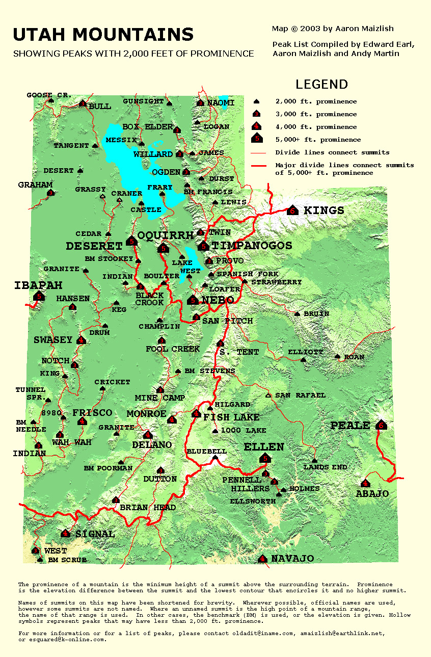
By looking at the list, you can see that West mountain is listed at #74 on this list and has 2100 feet of prominence. So let's sum up the prominence peaks that are around Provo/ Orem/Lehi/ Payson
There are 9 of them in this mountain rich area:
Ranking them in order it works out like this:
Rank Name
#5 Mt. Nebo 11928
#6 Flat Top 10620
#7 Timpanogos 11750
#28 Provo Pk 11068
#41 Spanish Fork 10152
#44 Loafer Pk 10687
#49 Lake 7690
#69 Boulter 8308
#74 West 6904
It is interesting that prominence doesn't actually correlate with the mountain's elevation, consider Flat Top of the Oquirrh range to Mt. Timpanogos, its loftier neighbor. Yet, Flat Top has more prominence.. It is dependent on where the saddle contour is found. The more you learn about prominence, the more intriguing
it becomes. I blame Bob Bolton for getting me into this new
passion. It really makes these peaks, many of them somewhat
non attractive on their own merits, more attractive due to the
prominence status that they have.
Canuck73 - Jul 7, 2008 8:35 pm - Hasn't voted
Isreal Canyon TurnoffThe name of the road is Stillwater Drive.
Dean - Jul 11, 2008 12:41 am - Hasn't voted
Re: Isreal Canyon TurnoffI just checked the road a couple weeks ago and there was a sign for Israel canyon on the highway. I didn't see the Stillwater Drive so thank you for that information. I will get that added. My son lives in Eagle Mountain so I'll be back that way soon. Have you had a chance to go up Israel Canyon?