
|
|
Mountain/Rock |
|---|---|
|
|
42.78990°N / 109.198°W |
|
|
Mountaineering |
|
|
12842 ft / 3914 m |
|
|
Overview
Lizard Head Peak is in the southern Wind River Range of Wyoming. Just one mile NE of the popular Cirque of Towers and slightly east of the continental divide, Lizard Head is the dominant peak of the immediate area. It is the third highest peak in the southern Winds and is 7 miles from the nearest higher peak. Apparent when viewing the range from distant points (from as far away as Jeffrey City), it becomes obscured by other peaks and foothills as the range is approached. Its dominant, distinctive shape is highly recognizable from points along the Popo Agie River to the east and SE but from the approach to the Cirque of Towers it is less striking. This accounts for its relative lack of popularity (as well as the dearth of clean lines on its broken faces). Those hiking downriver soon fully appreciate its stature upon viewing the east face which rises 2300 clean feet above Bear Lake. The northwest face, which holds the South Fork Glacier, is a dark face appearing at the head of the South Fork Little Wind River and presents a different character to those trekking through those areas. There is another small glacier under the true north face. Made of granite only slightly less solid than the neighboring divide peaks, several technical ascents have been made on various faces and ridges but it is more commonly ascended from the area of Camels Hump to the west by a time consuming ridge. The tilted plateau of the top few hundred feet leading to the summit is a looser erosional cap of pre-glacial material. Though the route in past the Cirque of Towers can seem busy, you are likely to be the only one headed for this summit.
Lizard Head from White Popo Agie. (photo: jimmyjay)
Approaches
Via Dickinson Park. At Hines General Store, in Fort Washakie, head towards the mountains on the Trout Creek-Moccasin Lake road. It turns to dirt, gets rougher and switchbacks for 16 miles to the Bears Ears trailhead turnoff. Policy varies from closed, to passable with a WR Reservation fishing license, to publicly open. This road and its trailheads are under a defacto closure as of June 25, 2007 according to the Forest service. Contact Shoshone National Forest for details. From the end of the road, cross the corduroy over the wet meadow and follow the North Fork trail for 13 miles to Lizard Head Meadows. The trail crosses the Popo Agie North Fork four times often requiring a roped crossing in early summer (July) but this approach is through emptier wilderness.Via Big Sandy Opening. Take the Big Sandy trail 6 miles to the Jackass Pass trail. Ascend 4 additional miles past Shaft Lake (mislabeled "North" Lake on the current USGS topo) and over the divide past the Cirque of Towers to the outlet of Lonesome Lake. Lizard Head Meadows is 2 miles downstream.
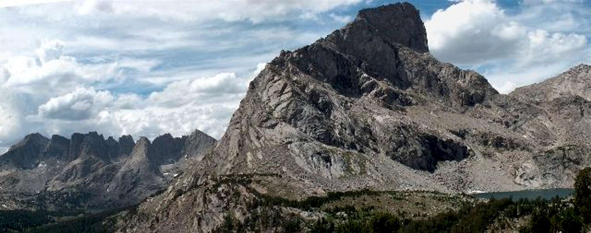
photo: Nathan Hand
Management and Regulations
Managed as the Popo Agie Wilderness of Shoshone National Forest. Western approach is managed by the Bridger Wilderness and National Forest. Wilderness regulations apply for camp locations, group size, campfire restrictions and ethics. Water filtration is required. Roads can remain closed until early June. Reservation use permits are purchased at sporting goods stores in Lander and Riverton or at Hines General Store in Fort Washakie. Fee-based campgrounds exist at both trailheads.Seasonal Conditions
Summer season in the Wind Rivers is generally July-September with snow lingering on the higher trails into July. A snow storm is traditional between the last week of August and the second week of September. This is often followed by a dry period with crisp temperatures for 1-4 weeks.Guides & Outfitters
Lizard Head is guided by JHMG and Exum.It is also available to participants in some NOLS courses.
Outfitting on the east approach is also available.
Etymology and Trivia
- While it is unknown who first applied the name "Lizard Head", it was first used for the famous gendarmed outlier ridge on Mount Bollinger (now known as Wolfs Head). The Hayden party of 1877 had bestowed this peak with the name Mount Chauvenet. When the name "Chauvenet" migrated NE, the name "Lizard Head" was reapplied to this peak on the 1937 15' quadrangle.
- 1st attempted ascent 1931, J.I. Hoffman. 1st successful ascent Drummond, 1933.
- "Popo Agie" is a French-phonetic spelling of the Crow words "Tall Grass" and is pronounced "po-po-zsha".
- The Lizard Head Peak 7.5 minute quadrangle was one of the last 7.5' quads to be published for the contig. Up until the early 1980s, climbers had to use as 15-minute quad from the 1930s.
- There is another (quite notorious) Lizard Head in the San Miguel Range of the southern rockies.
- Lizard Head is the 8th highest 12er in the range.
- The Cirque of the Towers is the name for the series of pinnacles and gendarmes on the Continental Divide cirque from Bollinger to War Bonnet. As is usual for this range, the best rock quality in this area is found on the post-glacial nunatak known as Pingora, though most of the rock in the area is superb.

Skyline: Camels Hump & Lizard Head from the Cirque of Towers. (photo: mcdermott22)

Northwest Face of Lizard Head Peak, glacier, and Camels Hump above South Fork Lakes of Little Wind River (photo: Bob Sihler)
Bonney, O.H. (1977). Guide to the Wyoming Mountains, 3rd Ed.; Swallow Press. Chicago,IL.
Lonesome Lake
A note about Lonesome Lake basecamps. This area became heavily impacted by the early 1980's with all wood in the area stripped through previous decades (for unnecessary campfire), fecal material appearing in the water, and cases of Giardiasis increasing. This was not necessarily caused by climbers (nor was it entirely the fault of the under-regulated herds of sheep). With increased regulation on group size, ethics education, and a ban on campfires, recovery seemed imminent but the sheer increase in visitors in the last decade has made necessary the enforcement of a no camping rule within ¼-mile of the lake. The requirement of a permit and a quota system were investigated and indeed may have worked but the anti-regulatory nature of Wyoming disdained this approach. The new requirements have concentrated campers to the the bench at Hidden Falls above the lake though many are camping downstream, at Shadow Lake or south of Jackass Pass. Awareness of ethics, the discontinuation of campfires, avoidance of forming groups and other minimum-impact techniques have been working and may keep this basin and approach from being increasingly regulated.Northwest Face of Lizard Head Peak, glacier, and Camels Hump above South Fork Lakes of Little Wind River (photo: Bob Sihler)
Sources/Bibliography
Turiano, Thomas (2003). Select Peaks; Indomitus Books, Jackson, WY.Bonney, O.H. (1977). Guide to the Wyoming Mountains, 3rd Ed.; Swallow Press. Chicago,IL.