

-
 43228 Hits
-
 92.32% Score
-
 38 Votes
|
|
Mountain/Rock |
|---|---|
|
|
46.15671°N / 10.49557°E |
|
|
Trentino / Lombardia |
|
|
Mountaineering, Skiing |
|
|
Spring, Summer |
|
|
11611 ft / 3539 m |
|
|
Overview
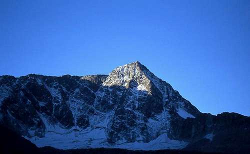
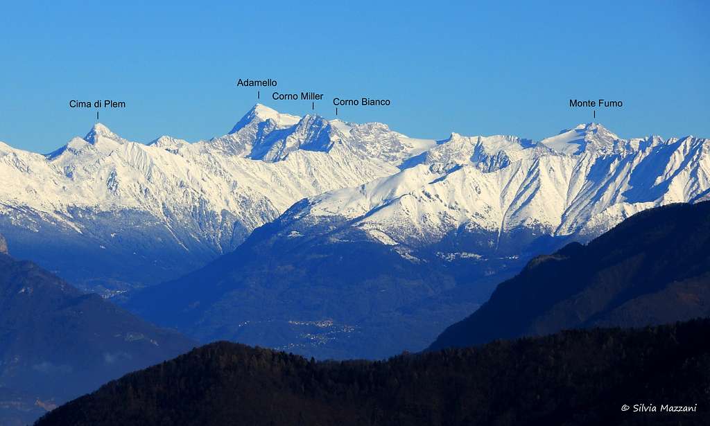
Monte Adamello 3539 m
The Adamello page will be kept in honor of Franz Rota Nodari, the member known as Franz77, the former owner of this page, fell on Mount Concarena on March 2018 during a climb.
What's New on this Page?
* June 14, 2018 - Page adopted
* June 16, 2018 - Overhaul of the page
Monte Adamello is a mountain located in the Southern Rhaetian Alps and with its 3539 m is the highest and the most representative peak in its namesake group, the Adamello Group, mountainous area shared beetween Lombardia and Trentino Regions. Monte Adamello is situated between Monte Falcone and Passo dell'Adamello and has a fairly simple topography, drawn by the two main watershed ridges, the ENE ridge and the SO ridge, and from the NW spur. The two great North and West granite walls give the mountain a majestic and harsh appearance. The North wall has a triangular shape, while the West wall has a trapezoidal shape. The aspect of the South East side is very different and therefore contrasts with these two majestic walls. It is much more gentle, rising like a small dome surrounded by a short strip of rock from the frozen plains of Pian di Neve. It is from this side that it climb the last section of the standard route to the summit.

The valleys leading to the Adamello have very different directions and have the shape of a “star”. All these valleys represents a possible way to reach the summit with different difficult and length. One of the most popular normal routes is the one on the Trentino side along the Val Genova, through the glaciers of Mandrone, Pian di Neve and Adamello, an itinerary that requires glacier equipment but is technically very easy.
The panorama offered by the summit is great, for its height and above all its position, and embraces the whole horizon. In World War I Adamello was the scene of fierce fighting between Italians and Austrians, and many were the fallen. There are still numerous remains of fortifications and armaments.

|

|
History
The first known ascent of the mountain was accomplished by Julius Payer with Giovanni Caturani on September 15, 1864, after an attempt made a week before the victorious ascent. The first summiters chose the Trentino side along the Val Genova, across the glaciers of Mandrone, Pian di Neve and Adamello, still today one of the most popular routes to reach the top. The first winter ascent was carried out on February 26, 1891 by W. Von Arlt with Amanzio and Giacinto Collini also from the Trentino side.
Getting There
The Parco dell'Adamello can be approached from Lombardia Region, Alto Adige and Trentino Region. By car, the Adamello Park can be reached using:
a) the state roads coming from Brescia and Bergamo; they combine near Darfo Boario Terme in to the only state road of the Mendola, which is near the western limits of the Park from Breno till the Tonale;
b) the state road coming from Valtellina to Edolo, through Aprica;
c) the state roads coming from Bolzano, through the road of the Mendola, and from Trento, through Cles and Malé, which reach the Park at Tonale Pass.

These are the main access valleys:
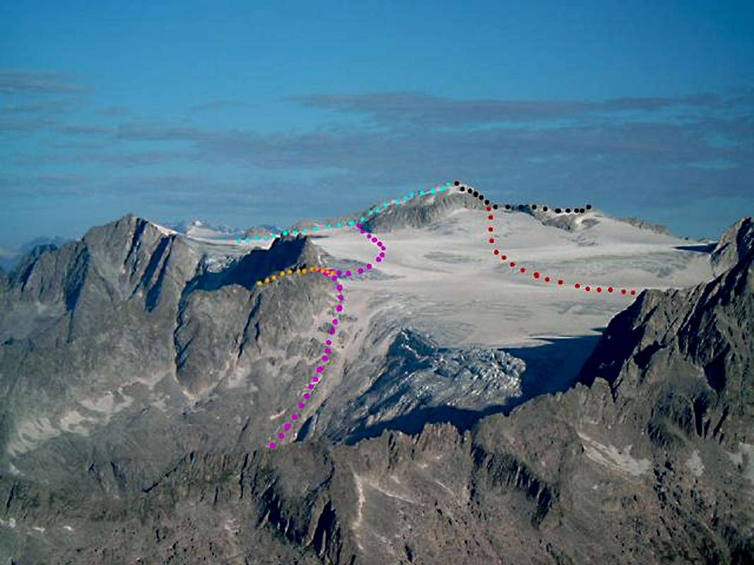
1. Val di Fumo - South, access from Valli Giudicarie and Bissina Lake. Lobbia glacier, Monte Carè Alto. Rifugio Val di Fumo; Segalla Bivouac. GREEN LINE
2. Val Saviore - South-West, access from Cedegolo and Saviore in Camonica Valley. Adamè glacier. Rifugio Città di Lissone; Baroni Bivouac; Rifugio Caduti dell’Adamello alla Lobbia. MAGENTA
LINE 3. Val Salarno - South-West, access from Cedegolo and Saviore in Camonica Valley. Salarno glacier. Rifugio Prudenzini; Jannantony Bivouac. ORANGE LINE
4. Val Miller (Val Malga) - West, access from Sonico in Camonica Valley. Miller glacier. Rifugio Gnutti; Ugolini Bivouac. CYAN LINE
5. Val d'Avio - North-West, access from Edolo, Temù in Camonica Valley. Avio and Venerocolo glaciers. Rifugio Garibaldi and Bixio Bivouac. BLACK LINE
6. Val di Genova - North-East, access from Tione, Val Rendena, Carisolo. Mandrone glacier. Rifugio Città di Trento al Mandrone, Rifugio ai Caduti dell’Adamello alla Lobbia. RED LINE

|

|
Normal Routes Overview
Adamello is a famous peak, one of the most climbed in the Alps in reason of its fabulous panorama and its standard routes never very difficult to get the summit. There are three main standard Normal routes: two ones starting from Lombardy (North-West and South) and another one starting from Trentino (North-East).
- ENE ridge
Difficulty: Alpine F
This route is considered the Normal route for the alpinist starting both from Rifugio Garibaldi (on the Lombardy side) and Rifugio Città di Trento or Rifugio Lobbia (on the Trentino side). The route largely coincides with the itinerary of the first summiters. The itinerary coming from the Lombardia side and that one coming from the Trentino side converge in the upper part near the Eastern side of the Corno Bianco.
- Trentino side
Access from Carisolo (TN) along the Val di Genova to Malga Bedole 1641 m. From Malga Bedole a well-marked path leads to the Città di Trento al Mandrone refuge 2449 m. You can choose to stay overnight here and tackle a greater difference in height the next day, or go up to the Ai Caduti dell'Adamello alla Lobbia Refuge 3040 m and stay overnight here, with a "lighter" day trip the next day. See here the full descritpion of the route Adamello from Val di Genova across the Mandrone glacier.
- Lombardia side

|

|
- South side
Difficulty: Alpine F
Another easy way to climb Monte Adamello starting from Rifugio Prudenzini (Lombardy)
- SW side
Difficulty: Alpine F
This route starts from Rifugio Gnutti (Lombardy) through Val Miller and has become popular after the equipment of the "Via Ferrata Terzulli".

|

|
Other routes

There are many other routes of about 600 meters on the mighty West, NW and N walls. The routes of this side are rarely climbed due to the bad quality of the rock. Amongst these itineraries the most frequently attended route is the North Ridge. Main routes:
- West Face UIAA IV, V, VI- 600 m
- NW Ridge UIAA II, III, IV, 600 m
- NNW Ridge UIAA IV, V, A1, then III and IV, 700 m
- North Ridge III, IV, IV+, 700 m
Red Tape

No fees no permits needed and no particular restriction in climbing and hiking. Adamello is located within Adamello-Brenta Natural Park, the largest protected area in Trentino, established in the year 1967. It's located in Western Trentino and with its 620.51 square kilometers includes the mountain groups of Adamello, Presanella and Brenta Dolomites, separated by Val Rendena. On the other side (Lombardy) there is the Parco dell'Adamello, which extends for 510 square kilometers on the left orographic side of Valle Camonica, in the north-eastern portion of the Province of Brescia.
We are in the Park of Adamello-Brenta groups and camping and overnight are not allowed but sometimes it is necessary (out of season).
Pay attention to the accessibility of Val di Genova road (usually closed to private cars from 9 to 18 in full summer).
Huts and Bivouacs overview
See the colours on the previous maps and images
Approach to the huts from the valleys: 1. Rifugio Val di Fumo. From Val di Fumo. Trail from Bissina Lake (road in Daone Valley from Valli Giudicarie - Trentino). GREEN 2. Rifugio Città di Lissone. From Malga Lincino on the Saviore Valley. Road from Cedegolo and Saviore in Camonica Valley (Lombardy). MAGENTA 3. Rifugio Città di Trento al Mandrone. From Rifugio Collini al Bedole (trailhead) on the Val di Genova. Road from Val di Genova, Carisolo, Val Rendeva and Valli Giudicarie (Trentino). RED 4. Rifugio Prudenzini. From Val Salarno. Trail from Malga Fabrezza (road from Cedegolo in Camonica Valley - Lombardy) across the Dossaccio and Salarno lakes. ORANGE 5. Rifugio Gnutti. From Val Miller (Val Malga). Trail from Malga Premassone (road from Sonico in Camonica Valley - Lombardy). CYAN 6. Rifugio Garibaldi. From Malga Caldea on the Val d’Avio (road from Edolo, Temù in Camonica Valley – Lombardy) across Pantano and Avio lakes. BLACK

|

|

|
At high altitude we count:
7. Rifugio Lobbia ai Caduti dell’Adamello.
Approaches: A) From Val di Fumo, Rifugio Val di Fumo and Lobbia glacier. B) From Val di Genova, Rifugio Città di Trento al Mandrone across the Mandrone glacier. C) From Rifugio Collini al Bedole (trailhead road Val di Genova) through the Lobbia Valley.
8. Bivacco Giannantoni
Approaches: A) From Rifugio Prudenzini. B) From Rifugio Lobbia and Rifugio Città di Trento.
9. Bivacco Ugolini
Approaches: A) From Rifugio Gnutti climbing the Via Ferrata Terzulli B) From the Bivacco Giannantoni C) From Rifugio Lobbia across the Pian di Neve.
10. Bivacco Brixio
Approaches: A) From Rifugio Garibaldi B) From Rifugio Lobbia and Città di Trento.
 |
 |
 |
 |
 |
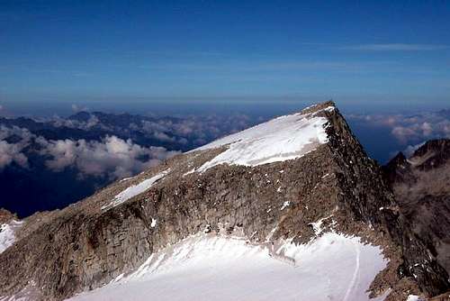
The summit of Monte Adamello
The peak has a pyramidal shape and is possible to see it from a lot of places on the Pianura Padana and from a lot of peaks in Lombardy.

|

|
Views of Adamello
 |
 |
 |
 |
 |
 |
 |
 |
 |
") |
 |
 |
When To Climb
Mountaineering: from June to September - in early season be careful to the glaciers' conditions, obviously!
Ski-mountaineering: from March to May
Camping
We are in the Park of Adamello-Brenta groups and camping and overnight are not allowed but sometimes it is necessary (out of season). The refuges are many and there are good bivouacs too.
The Adamello glaciers
The Adamello Group is one of the most icy areas in the Italian Alps. It includes about 80 glaciers with different wideness (from less than 1 sqkm to 18 sqkm of the Adamello glacier), exposure and morphology and it has been studied by various researchers since more than a century of years. The glacier morphology of this group has a particular interest because of its singularity. It has Scandinavian and Nordic plateau structure. This apparatus with its different effluences and tongues has different names depending on the valley that they occupy.

|

|
On the North, the glacier arrives till 2400 m a.s.l. in Trentino Region and it is called Ghiacciaio Mandrone. In the South side there are three tongues called Adamè, Salarno and Miller. Every flux of ice takes its name from the valley and also the route of climb. The highest plateau of ice has the impressive name of Pian di Neve. The water that comes from the glaciers is divided between different watersheds: on the North side the Sarca river through the Trentino Region enters the Garda Lake; in the South side, tributary rivers arrive to the Oglio river and then enter the Iseo Lake.

|

|
Meteo
Guidebooks and maps
-Guidebooks

"Adamello Vol. I - Pericle Sacchi Collana Guide dei Monti d'Italia CAI-TCI
-Maps
"Adamello - Presanella" - Tabacco scala 1:25000
"Adamello, Val di Fumo, Val di Genova" - Kompass n. 638
"Adamello - Presanella" - 4LAND Alpine Cartography n. 138 1:25.000
In Memory of Franz Rota Nodari

Francesco Rota Nodari, Franz for everyone, member of the Club Alpino Italiano Sez. Bergamo since 1987 and of the Club4000, died on March 23rd 2018 during a climb on Concarena 2549 m, the highest mountain of the Prealpi Bergamasche. He fell down during the descent from the mountain after having climbed a new route, due to the breakdown of a peg. Expert mountaineer, he had climbed all the 82 4000 of the Alps. He worked at the Polytechnic as an expert researcher in glaciology. He had joined SP in the year 2005 and registered as Franz77. Rest in peace, brother!