

-
 45114 Hits
-
 93.8% Score
-
 44 Votes
|
|
Mountain/Rock |
|---|---|
|
|
36.40080°N / 115.179°W |
|
|
Clark |
|
|
Hiking |
|
|
Spring, Summer, Fall, Winter |
|
|
6943 ft / 2116 m |
|
|
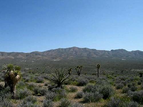
Gass Peak as viewed from the north in a desert setting.
Overview
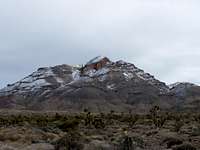
Gass Peak with some snow. Dec 18, 2007
Want a view of Las Vegas that is only equaled by an airplane? Head for Gass Peak, a peak that is prominent on the northern side of the Las Vegas area. Try spending the night atop Gass Peak. Most of the locals look up at the mountains that ring their fair city and probably couldn't tell you the names of most of the peaks. Gass Peak also is a peak sought out for being one of Nevada's 178 prominence peaks although it comes in as #165.
Some antenna structures adorn the top of this peak but no road makes its way up to the summit. All of the antenna structures were brought in by helicopter and a wind sock is ever present to help aid pilots when they return workers for repair or upkeep. The trail from the north is a 4 mile effort and is mostly class one. Wind is the main detractor that makes it more of an effort at times but the heat that hits the Las Vegas and the desert areas nearby make this a peak that is much more friendly to climb in the spring or fall although winter is not
out of the question for when there is no snow.
How did the peak get its name? Here is the answer: CLICK HERE
Want even more information on Octavio Decateur Gass, OK,
CLICK HERE
Here is a LINK to a panoramic pic taken by H.W. Stockman
Getting There
 |
 |
 |
 |
From Las Vegas take HWY 95 north. When you get to Exit 93 set your odometer to zero.
At 2.5 miles you will drive by the turnoff for Mt. Charleston. Keep going straight.
At 16.5 miles you will see the sign for Corn Creek Road. Start slowing down and get ready to make a right turn.
At 16.7 miles turn right at the turn off for Corn Creek Road.
A map down below in section 8 to allow those with dial up modems to not get hammered by the time it takes to load. Hopefully this will make it easier for all and still provide the information I'm trying to give.
I have placed a map down below in section 8 to allow those with dial up modems to not get hammered by the time it takes to load. Hopefully this will make it easier for all and still provide the information I'm trying to give.
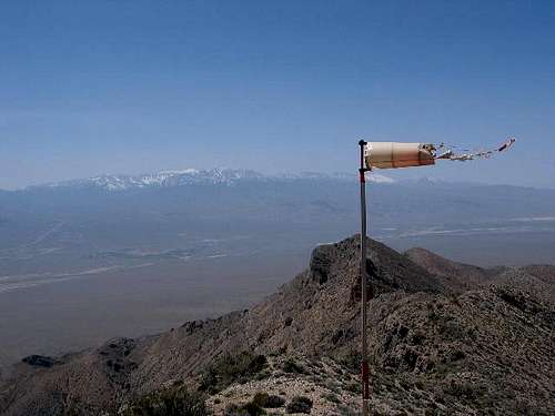
Windsock near summit
Red Tape
No permits are needed for Gass Peak. The main rule to observe is that the road which is listed as a service road is not authorized to drive on. This road branches and neither one of these roads services the peak. All I can figure is that they might be old mining roads and were popular with the 4wheel set at one time. Firearms aren't allowed.
You must park here
A large part of the wildlife refuge is closed to the public since it is also part of the Nellis Air Force Range. Hiking, Camping, Picnicking, Backpacking, and horseback riding is permitted in the publicly accessible portion of the wildlife refuge. Be sure to sign the register at the Corn Creek Station. Sign before you go to the peak so that others know of your whereabouts.
When To Climb
This peak could be climbed anytime of the year but the heat in the summertime can be stifling and making this much more trying. March and April are good spring months and October and November would be good fall months. A lot of snow might make this peak more treacherous but I'm told that this peak rarely gets snow that lasts for any great length of time.
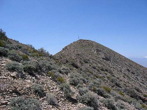
Summit ahead
Camping
There are no developed campgrounds in the area. However, you could most likely car camp or sleep in your vehicle at the trailhead. Fires are not allowed in the Desert Wild life area.
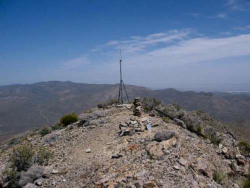
The summit
Mountain Conditions
This is the best source:
For more information, contact:
Refuge Manager
Desert National Wildlife Refuge
1500 North Decatur Boulevard
Las Vegas, Nevada 89108
Phone: 702-646-3401

Wintry conditions

Desert National Wildlife area
This is truly a unique area, in fact, the Desert Wildlife area is one of the largest (if not the largest) in the United States. Its purpose is to preserve and protect the flora and fauna of a special area which is amazingly close to Las Vegas. Much of the area is located on what is the Nellis Military reservation and is off limits to visitors but the area that is not off limits is open to the public.
Here are some links to information on this area:
Link Has info about a little hike near the station.
Link
Desert National Wildlife Refuge page by redsplashman23
A sad event occurred in the summer of 2005. Read this article. While this happened to the south of Las Vegas, it indicates that sometimes the Mountain Sheep may be in danger from things that aren't always obvious.
More on getting there
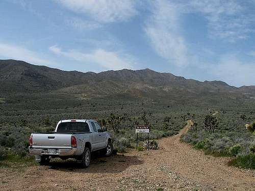
Restrooms and interpretive information is available at the Corn Creek Field Station as well as a register to sign in. Please take the time to sign in as this may help with future funding by showing that the area is well visited by people like ourselves. Also it isn't a bad idea to put down where you are headed and even when you expect to return. Continue on past this area and shortly the road T's and you take the right fork for Gass Peak road. Follow the Mormon Wells road for 4 washboarded miles and watch for the Gass Peak road which is on the right. Go another 8.5 miles on a high clearance road (make sure your spare tire is inflated, don't have one of those donut kind), and you'll come to the TH (not noted as such) shown in the picture where my truck is parked.
Before traveling through the range, visitors are advised to check fuel, carry water, have a spare tire, and notify someone regarding travel plans (again, sign the register outside the Corn Creek station.
Just beyond the Corn Creek Desert Wildlife station is a helpful sign
that has mileage and destinations of the areas roads.

Additional info
Plane crash story
Jim Boone's Trip report and web site. This is a good read and he has some neat pics with his story. Follow his link to the Desert Wildlife area and then to other links to his other trips and hikes.
Another link
to some Gass Peak pics.
Check that spare tire as this STORY shows it is a smart thing to do.
Did I mention there is a route in from the south? I don't know it but this pic probably shows some of the route since it is a nice shot of Gass looking at it from the south.

Gass Peak from the south
SP'er MoapaPk posted a trip report on the southern route HERE. Be aware that you can't
travel on the BLM roads that lead to the southern route anymore in a vehicle and if you do you are subject to a large fine. See My comments for more information.
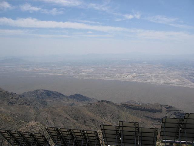
The view of Las Vegas
One of my fellow summitposters wanted to know why I hadn't posted any pics of Las Vegas in the photo section. Well, I did, check the photos and you'll find that I did post one. The problem I had was the amount of pollution that was covering everything up and my photos fared poorly. Surprisingly enough, the wind on the summit of Gass while I was there was blowing in excess of 50 mph. Here is another shot of what I was seeing from the summit. On a clear day, the view would knock your socks off.
External Links
- Gass Peak by Jim Boone
Excellent information about the hike from the north side. - Southern Route descent
Scott Surgent has posted an excellent trip report HERE
Trip Report from News 3 in Las Vegas