
-
 25723 Hits
-
 88.53% Score
-
 27 Votes
|
|
Mountain/Rock |
|---|---|
|
|
28.75440°N / 17.885°W |
|
|
Hiking |
|
|
Spring, Summer, Fall, Winter |
|
|
7959 ft / 2426 m |
|
|
Overview
 Roque de los Muchachos seen from Pared de Roberto Roque de los Muchachos seen from Pared de Roberto |
Roque de los Muchachos is La Palma's highest summit and as such certainly deserves its page on SP. Still I have been hesitating to put it up. Why? It is a drive-to summit, with a developed asphalt road right to the top, a parking lot right on the summit and an information booth right there.
 On the path from Espigon del Roque to Roque de los Muchachos
Moreover the northern slopes of Roque de los Muchachos and the neighbouring Roque Chico and Pico de la Fuente Nueva are "littered" with astrophysical telescopes. Weather on Los Muchachos is as fine as it can get anywhere in the EU, so many of the agencies and universities have set up shop here. It is exactly for access to the telescopes that the asphalt road to Roque de los Muchachos has been built and the telescopes are the reason why it is closed for regular traffic.
 |  |  |
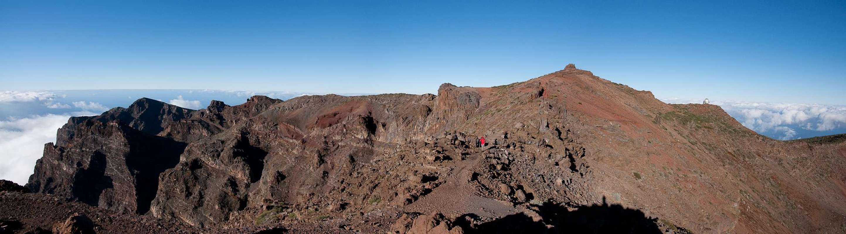
But so much for the drawbacks. Let's concentrate on the mountain itself for a while. Roque de los Muchachos is one of the mountains on the rim of Caldera de Taburiente, the world's largest volcanic erosion crater. While the outward side of that crater shows gentle slopes, from the inside you will see huge vertical drops. Roque de los Muchachos itself has a 800m vertical south face, which is clustered with towers and spires. The biggest of these spires - Espigon del Roque - is connected to the main summit by a narrow ridge. On the latter there has been developed a paved hiking trail which negotiates the most difficult sections by staircases, hewn onto the rock. Most likely the Espigon is the most wonderful lookout spot on the whole island
 |  |  |
From above you can reach the Roque de los Muchachos via the Ruta de la Cresteria Trekking Trail - you don't have to use the road. From the summit you will be able to enjoy views across the whole island of La Palma as well as neighbouring La Gomera, El Hierro and Tenerife. But be sure to start out early. Around noon heavy trade wind clouds start to gather on the north-eastern side of the island. Often they reach the caldera rim and obscure views in the matter of seconds.
360° Summit Panorama Espigon del Roque
  |
The Telescopes on Roque de los Muchachos
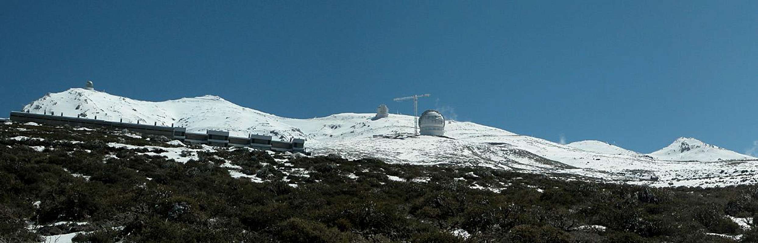 |
When I finally decided to put up this page I tooled around with the notion of putting up a telescope section. Those golden, silvery and white domes looked absolutely futuristic on the snow and rime covered mountains. Almost aseptic, just like from outer space. On the other hand I'm a physicist by education and I couldn't think of a more perfect place to do one's job. Stargazing at night, climbing and hiking in this beautiful setting by day. What more would you want?
With an elevation of 2300 - 2400m the observatories are well above the cloud layer, which usually forms around the Islas Canarias. The trade winds push the clouds up to elevations between 1000m and 2000m and only on wet days the mountain tops of the Caldera de Taburiente will be shrouded in clouds around noon and the early afternoon. At night the fog retreats leaving the skies as clear as can be. Therefore a number of astrophysical institutions have built the following observatories on or near Roque de los Muchachos.
- The Isaac Newton Group of Telescopes (ING) operates three telescopes:
- the 4.2 m William Herschel Telescope
- the 2.5 m Isaac Newton Telescope
- the 1 m Jacobus Kapteyn Telescope.
- the 4.2 m William Herschel Telescope
- the 2.5 m Nordic Optical Telescope (NOT)
- the 1 m Swedish Solar Telescope (SST) operated by the Institute for Solar Physics
- the 0.45 m Dutch Open Telescope (DOT)
- a 0.6 m optical telescope
- the Carlsberg Meridian Telescope (CMT)
- the 1.2 m Mercator Telescope
- the 2 m Liverpool Telescope
- the 10.4 m Gran Telescopio Canarias (almost finished)
- the 3.6 m Telescopio Nazionale Galileo (TNG)
- the 17 m MAGIC Telescope, an air shower Cherenkov telescope for observing high energy gamma rays
For specific information on each of the telescopes you can visit Wikipedia, where the listing is taken from.
Getting There
 Palmeran windmill
La Palma, like all the other Canarian Islands can easily be reached from almost all major European airports. The airport is rather small and compared to Tenerife or Gran Canaria air traffic is rather low. There are almost no regular flights but all year round you'll be able to book charter flights. The airport itself is located on the eastern coast of the island, almost at its centre.
In any case the easiest access to Roque de los Muchachos is from La Palma's mountain highway LP-22. There are several possible trailheads but the most reasonable is the one near Pico de la Cruz. The parking space there is limited. For trekkers the best access points are both trailheads of the Ruta de La Cresteria Trail. You can find the info on the Caldera de Taburiente Page
Since Roque de los Muchachos is located almost on the opposite site of the Caldera de Taburiente with respect to the airport there are two almost equally long itineraries:
- Western Approach
Follow LP-1 from the airport through the capital of Santa Cruz. After the city, at El Morro, LP-22 turns off to the left (west). There are signs for the observatories at Roque de los Muchachos. Follow the winding road towards the small parking lot near Pico de la Cruz.
- Eastern Approach
Follow LP-1 northward to the first roundabout where you turn westward towards Los Llanos along LP-2. The road climbs to Cumbre Nueva, which it crosses through the long Cumbre Tunnel. Head down to Los Llanos after which you regain LP-1 northward. The road winds down into Barranco de las Angustias and up again to Mirrador El Time. For the next half hour it follows the coast line from afar until it reaches Las Tricias. Be sure to have a look at the nice windmill they have there but head on to Hoya Grande. There turn south-eastward onto LP-113 which will take you to the observatories and on to Pico de la Cruz.
Red Tape
 Every once in a while the Canarian sky turns a perfect blue above the trade wind clouds.
The Caldera de Taburiente has been declared National Park (Parque Nacional de la Caldera de Taburiente). The park boundary runs across all the summits, so Roque de los Muchachos belongs to the park too. Leaving the trails or camping are restricted within park boundaries.
Also the whole observatory area is restricted area. You can leave the road here but you will be reminded by quite a number of signs that the area belongs to the astrophysics complex. The road to the summit is closed to the regular tourists, only observatory personnel can use them.
When To Climb
 |
Like all summits on La Palma, Roque de los Muchachos can be climbed all year round. We had to settle for the road access in Feb 2005 since the freak weather conditions had deposited a thick layer of snow and ice on the summit for which we weren't equipped.
Accommodation
Camping is a bit of a problem on La Palma. There are some official campgrounds in the north but certainly not near Roque de los Muchachos. There are, however, a couple of "Zonas Recreativas" where sometimes you are allowed to pitch a tent. On the caldera crest there are no such places, only near Punta de los Roques (south of Pico de la Nieve) you can find a cabin (called rifugio). Most trekkers on Ruta de la Cresteria use the cabin or the space around it to sleep below the open sky.Other accommodations are no problem. Every European travel office will be able to book hotels, rooms and apartments for you. I won't include any links here because all of them definitely are commercial. Another option is to rent a finca (rural house) from the owners directly. You'll have to google for these but sometimes prices are low enough for the scheme to be worthwhile.
Weather Conditions
[img:96342:aligncenter:medium:Every once in a while the Canarian sky turns a perfect blue above the trade wind clouds.]Usually all year round the Canarias have the same weather with little alterations: north-eastern trade winds which deposit fog and dew on the north-eastern slopes of the islands. The eastern and southern parts usually are very dry and there you'll get some hours of sunshine each day. Especially on the higher islands like La Palma you usually don't have to worry about weather too much. The mountaintops will stick out of the clouds.
Now here's the problem: when we were on our vacation to La Palma in late February 2005 we had a week of fierce western winds which were loaded with moisture. We had veritable downpours for hours on end and several times couldn't even drive by car because the roads were flooded. I'm quite sure that this was a freak phenomenon. The western side of La Palma usually gets 28cm (19 inches) of rain per year!
There are no reliable weather forecasts for the mountain regions of La Palma. Often a cloudless day turns into a foggy one within half an hour. Especially the Cumbre Vieja Range is prone to these fogs and here orientation among the lava and scree fields gets very difficult. This is the main reason why you should never leave the trails there.
Forecasts for the coastal regions, however are available. You have to subtract 1°C for every 100m of altitude so that Roque de los Muchachos will still be near freezing when the coasts have already fine and sunny beach weather. The following table gives a little overview about the average weather data of the capital of Santa Cruz:
| Month | Jan | Feb | Mar | Apr | May | Jun | Jul | Aug | Sep | Oct | Nov | Dec |
| Avg. day temp.[°C / °F] | 21 / 70 | 21 / 70 | 22 / 72 | 22 / 72 | 22 / 72 | 24 / 75 | 25 / 77 | 26 / 79 | 26 / 79 | 26 / 79 | 24 / 75 | 22 / 72 |
| Avg. night temp.[°C / °F] | 15 / 59 | 14 / 57 | 15 / 59 | 16 / 61 | 17 / 63 | 18 / 64 | 19 / 66 | 21 / 70 | 21 / 70 | 19 / 66 | 18 / 64 | 16 / 61 |
| Water temp.[°C / °F] | 19 / 66 | 18 / 64 | 19 / 66 | 19 / 66 | 19 / 66 | 20 / 68 | 22 / 72 | 23 / 73 | 22 / 72 | 22 / 72 | 21 / 70 | 20 / 68 |
| Sunny Hours / Day | 5 | 6 | 6 | 7 | 8 | 9 | 10 | 9 | 8 | 6 | 5 | 5 |
Maps 'n' Books
Please excuse me if I only post German maps and books. I know there are editions in all European languages but I'm not aware of them. Any help is very welcome!I have used a fantastic map by Freytag & Berndt which shows all of the many hiking and biking trails of the island. With its scale of 1:30000 it is still large enough to be usefu for car tours as well. Moreover here you will find all the new designations and acronyms (which were changed some few years back).
- La Palma
1:30000
Edition Freytag & Berndt
ISBN: 3-7079-0346-X
The guidebook I used is every bit as good as the map with excellent tour descriptions. It is available in English as well but I am not sure about the quality of the translation.
- La Palma
A. and W. Wolfsperger
Rother Verlag
ISBN:
3-7633-4246-X (German)
3-7633-4808-5 (English)