-
 60908 Hits
-
 86.85% Score
-
 23 Votes
|
|
Mountain/Rock |
|---|---|
|
|
37.16060°N / 121.897°W |
|
|
Santa Clara |
|
|
Hiking |
|
|
Spring, Summer, Fall, Winter |
|
|
3486 ft / 1063 m |
|
|
MOUNT UMUNHUM OPEN TO THE PUBLIC
As of September 18, 2017, after decades of inaccessibility, Mount Umunhum has finally become open to the public. The status of Mount Umunhum has changed many times since the creation of this page, so many photos here will reflect what the summit used to be, and will remain attached to this page for historical reference. My hope is that with the opening of the mountain, new photos will be posted by other contributors.
Overview

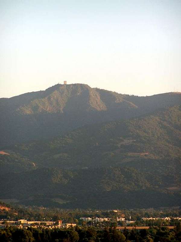
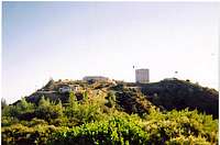
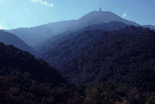
Mt. Umunhum (which roughly translates to "Hummingbird" in Ohlone Indian; pronounced Uhhh-mun-uhm) is a major landmark in the Southern Bay Area and a truly unique peak. A mere three feet higher than its neighbor Mount Thayer*, most people recognize it from the huge "box-like structure" that stands on its summit, clearly visible from all around the South Bay. The structure is known by several monikers such as "The Monolith", "The Cube", and "The Radar Tower", yet is mostly known simply as "The Box". The Box is an 84.5 foot tall foundation remnant of an AN/FPS-24 U.S. Air Force radar tower. Between 1957 and 1980, the infamous Almaden Air Force Station, which occupied the summit area, maintained many radar and transmitting equipment as lookout for Soviet attack planes coming in over the Pacific. The Box at one point had a large radar dish on top of it until the closure of the station. Such bulky radar equipment quickly became outdated and replaced with newer radar technologies, and in the early 1980s the Air Force decommissioned the station and left everything atop the mountain abandoned. They left behind not just a radar station, but an entire town. The summit and surrounding slopes of Mount Umunhum were quite isolated from San Jose, so the station needed something of a self sustaining populace. During the operating years of the station, the "town" boasted amenities such as residential buildings, a recreation center with swimming pool, a banquet hall, a commissary, and even a bowling alley.
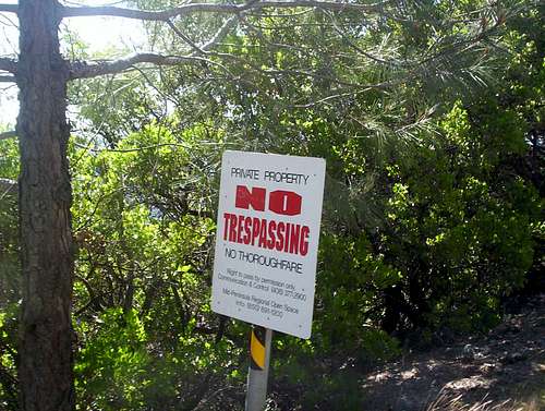
Because the Almaden Air Force Station was built in a time where regard for environmental and human health was a bit stalled, the structures contained a fair amount of lead paint and asbestos. From the early 80s all the way into the early 2010s, the summit structures sat, slowly decaying and falling into disrepair. Even though the land on which the station sat on was Mid Peninsula Open Space land, public access to the mountain was strictly prohibited. All road accesses to the summit crossed heavily guarded private property owned by very isolated and sometimes violent individuals. Any non-road approach to the summit involved a tedious bushwhack through steep, thick, poison oak covered slopes, with the added danger of Mexican Cartel-run clandestine backcountry marijuana grow operations. Because of Mount Umunhum's isolated, foreboding nature (as well as the eerie presence of the summit Box), it generated quite a bit of inspiration for local urban legends (see below section). For many years, the only way to visit Mt. Umunhum was to trespass. During the off limits years, the mountain could have been considered class S10 on the "Sneak Peak Climbing" scale.
*The elevations surveyed by the USGS for Mount Umunhum and Mount Thayer were 3,486 feet and 3,483 feet, respectively. The cleanup and preservation of the mountain tops involved resurfacing and reforming the summits from bulldozed lots to more natural landscapes, and in doing so, heightened both summits by some amount. The verdict is still out on the new elevations, so until USGS provides updated elevations, I will list the elevations of these mountains by their old measurements. Mount Thayer may be even taller than Mount Umunhum!
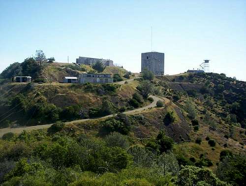
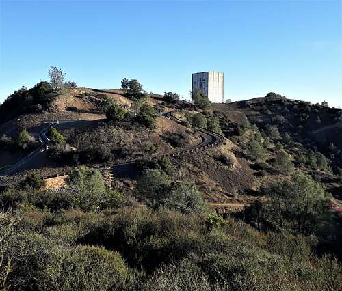
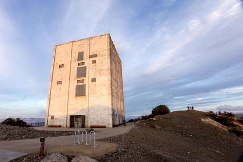
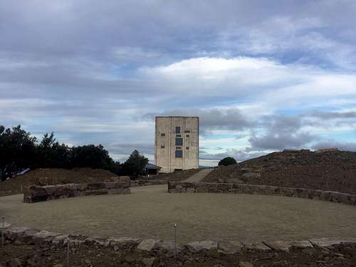
Luckily in the early 2010s, the open space district received a federal grant to clean the summit, restore native plant life, and open the summit to the public, complete with visitor facilities. Over a period of several years, all structures (besides the Box) were completely torn down and the summit and surrounding slopes were restored to match more of the natural environment. The road to opening was not an easy one, as the project suffered delays and design disagreements, most notably regarding what to do with the 5 story summit Box. After much back and forth, the Box was deemed a Santa Clara County Historical Landmark, and it was decided that the Box would remain intact and standing on the summit. Informative plaques were installed, new trails were built, parking lots enlarged, and roads were re-surfaced. What was once a strictly inaccessible, decrepit, and yet somewhat wild place has now been changed into a place of legal recreation and access, the way that mountains should be, free for anybody to enjoy who is inclined to do so. Mount Umunhum is in many ways a symbol of the South Bay, and to have such a resource within spitting distance of Silicon Valley is very special.
Mount Umunhum's summit can be reached via the Mount Umunhum Trail, a 3.4 mile (one way) multi-use trail, or by vehicular access via Mount Umunhum Road.
- Mid Peninsula Open Space Page for Mt Umunhum, and the Sierra Azul Open Space Preserve
- A very detailed .PDF map of the Preserve
    
 Getting There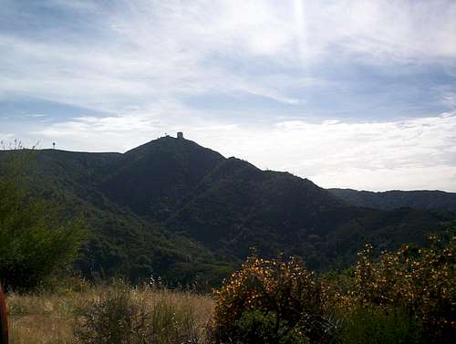
|