Overview
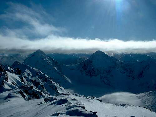
![From Rabbit Lake, September]() The west side of North Suicide, seen from Rabbit Lake
The west side of North Suicide, seen from Rabbit LakeNorth and South Suicide Peaks are not only two of the most eye-catching Chugach peaks visible from Anchorage, they are also the two most uniform. These nearly identical twins rise just short of a mile above the city, with a height difference of only sixty feet.
North Suicide is the higher and slightly more rugged of the two summits. It is on the left in the photo in the frame at the bottom of this page, which was taken from neighboring Ptarmigan Peak. North Suicide has 1500 feet of
prominence.
While North Suicide Peak sees a fair number of ascents, it is rare to see another person on the upper mountain at the same time. Usually footprints and melted tracks are the only evidence of other climbers having reached the summit.
"Suicide Peaks" was a name given by early railroad workers on a group of four peaks in this area, but over time only the twin peaks above Rabbit Lake have retained this name.
[Note: A prior version of this page, by former SP member Clint Helander, covered both Suicide Peaks. Comments and climber's log entries for this page may relate to the earlier version. Some material from the earlier page has been retained.]Getting There
![The Suicides in Summer]() N & S Suicide from McHugh Peak,summer
N & S Suicide from McHugh Peak,summer
There are three main ways to approach the Suicide Peaks:
Rabbit Creek Approach: From the Seward Highway (Alaska Highway 1) in Anchorage, take the DeArmoun Road Exit and follow DeArmoun Road eastward into the mountains to the end of the pavement. Turn right onto Canyon Road and follow it to the permanently closed gate at the end.
About half a mile before this permanently closed gate there is a bar gate that is locked from late evening until rather late in the morning--read the sign carefully for latest opening and closing times and don't get locked in! You can park below this gate and walk half a mile to the end of the road if the lock-in is a concern.
Regardless of where you park, parking is very limited at this trailhead, so have someone drop you off if at all possible.
From the end of the road, hike up a gently rising track into the valley. The first couple of miles are brushy, but then the views open up and the Suicide Peaks will guide your progress. 4.3 miles from the trailhead you will encounter Rabbit Lake in the tundra. You will have climbed 1100 feet to the lake, and a 2000-foot climb awaits to the top of North Suicide.
![Camping at Rabbit Lake]() Camping at Rabbit Lake with North Suicide behind, September
Camping at Rabbit Lake with North Suicide behind, September Park in the paved, well-developed parking at McHugh Creek wayside, located on the Seward Highway three miles beyond Potter Marsh at the south end of Anchorage. Note that the upper parking lot is gated off at certain times; check the sign and park outside the gate if your itinerary so dictates. Follow the
Turnagain Arm Trail back toward the city. After half a mile, turn right at a posted junction onto the
McHugh Lake trail, which continues six miles to Rabbit Lake. The midsection of this hike is brushy and two people were killed by a grizzly here in the not too distant past; bring bear spray and make noise. Elevation gain is 3000 feet to Rabbit Lake and 5000 feet to the summit.
Falls Creek Approach: The small Falls Creek Trailhead is by milepost 106 of the Seward Highway. The
Falls Creek Trail climbs 3000 feet in three miles along the creek to tiny Falls Lake, on the opposite side of the Suicides from Rabbit Lake.
When To Climb
![North Suicide Peak]() West side, April
West side, April
Most people climb these peaks in summer, and the route descriptions are below are geared to summer climbers.
Climbing in the winter gives the "big mountain" feel. For North Suicide, the most straightforward route from the Rabbit Lake is the southwest face, with slopes ranging from 30-50 degrees.
Routes
From Rabbit Lake, the easiest ascent of North Suicide is walk straight toward the saddle between the two Suicides (Windy Gap) and then bear right up the very prominent gully that heads just left of the top of South Suicide. This is
Hauser's Gully, a 30 degree snow couloir in May and June, a miserably loose scree chute later in the season. When you can, exit the gully to the left, scramble class 3 terrain over to Windy Gap itself, and follow the ridge easily to North Suicide. There is a sheep path most of the way. The last bit of ridge to the summit is class 3.
From Falls Lake, gain the
south ridge of
South Suicide and follow this (class 2) to South Suicide, from which you can easily walk down to Windy Gap and proceed as above.
The peak is also done occasionally by its north ridge, which is described as class 4 on
this page.
The most pleasant way to climb North Suicide in summer is to climb
South Suicide first via its northwest shoulder route from Rabbit Lake, and then to cross to the north peak via Windy Gap.
Camping
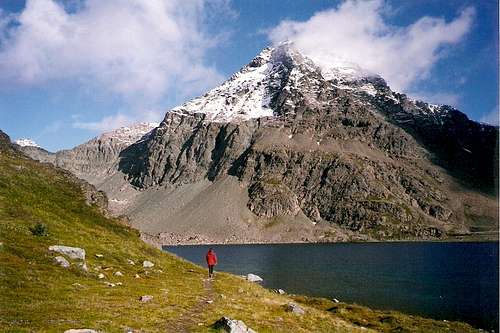
![South Suicide]() Rabbit Lake from Ptarmigan Peak, June
Rabbit Lake from Ptarmigan Peak, June
Rabbit Lake is one of the most beautiful places to camp in all of the Chugach. It is secluded, yet close to Anchorage. The pure lake shines a dark, sun-soaked blue, while the Suicide Peaks, Homicide Peak, Ptarmigan Peak, and the entire McHugh Valley fill the horizon. The tundra is very tent-friendly. Some people manage to pull rainbow trout from the lake (fishing license required).
Red Tape
No permits are required, except for camping by large groups. Campfires are not allowed in this area. The McHugh Creek trailhead has a $5 parking fee. As of late 2016, a $5 fee is also being collected at the Canyon Road trailhead. If you have purchased an annual state parks sticker (550 W. 7th Avenue), you won't need to pay the parking fee.
Contrary to information that remains on some websites, none of the trails accessing this peak crosses restricted private land. Access issues from the Rabbit Creek Trailhead were fully resolved in the summer of 2007.
Links
Chugach State Park

 34121 Hits
 92.04% Score
 37 Votes
 The west side of North Suicide, seen from Rabbit Lake
 N & S Suicide from McHugh Peak,summer
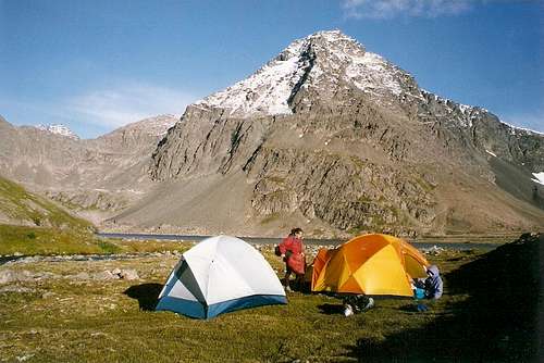 Camping at Rabbit Lake with North Suicide behind, September
 West side, April
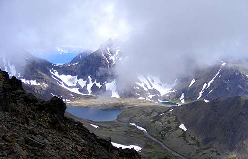 Rabbit Lake from Ptarmigan Peak, June