-
 26617 Hits
-
 88.61% Score
-
 27 Votes
|
|
Mountain/Rock |
|---|---|
|
|
43.49360°N / 114.9356°W |
|
|
10095 ft / 3077 m |
|
|
Overview
Smoky Dome is a enormous mountain that rises just north of the small town of Fairfield, Idaho. The south side of the peak is lightly timbered and mostly rock free. The north side of the peak rises more abruptly and is much rockier. Smoky Dome can be seen easily on clear days from the Magic Valley, nearly 75 miles away.
Smoky Dome is the highpoint of the Soldier Mountains in south central Idaho (Idaho Range Highpoints). In addition to being the highpoint of the range, it is the 21st most prominent peak in Idaho, with 3255' of prominence (see the entire Idaho list here). Smoky Dome is most often viewed from the south from Highway 20. From that vantage point, it rises 5000 feet over the Camas Prairie.
Smoky Dome is not climbed often, especially by non-Idaho standards. It probably sees 50 visitors a year and half of those are snowmobilers visiting in the winter. All routes to the top are class 2. While easy technically, each route on the peak requires at least 3600' of elevation gain to get to the summit.
Smoky Dome is known to locals as Soldier Mountain. Everything in the town of Fairfield is named after this peak, like Soldier Mountain Resort (a golf course), Soldier Mountain Ski Area, etc...

 |  |
Getting There
East side:
From US 20 in Fairfield, turn LEFT onto SOLDIER RD/CENTER ST. Follow the road 1.9 miles to a stop sign. At the stop sign, turn RIGHT onto BASE LINE RD. Follow BASE LINE RD. 0.2 miles, then turn LEFT onto SOLDIER CREEK RD/NF 094. Continue to follow NF 094 (Portions unpaved) to the ski lift parking lot. From the ski area, continue on NF 094 until you reach the South Fork of Soldier Creek coming in from the west. Park here. A two-wheel drive vehicle will get you here.
South side:
From Fairfield, turn north on the only paved road (SOLDIER RD/CENTER ST) and follow it 1.9 miles to a stop sign. At the stop sign, turn left (west) onto Baseline road and follow it to its end. At the end of Baseline, turn north towards the foothills and turn left onto Chimney Creek road when you reach a sign identifying the route to the Ear Creek Corrals. Follow this road through a gate, and follow it several miles until a major fork and a sign for the Ear Creek Corrals is reached. At this fork, turn east. The road will immediatley reach another gate. Continue through the gate for several more miles past the Ear Creek Corrals. Soon after the road passes the corrals, it takes a sharp turn northwest. After that turn, look for a road on the right hand side heading up a ridge. Follow this road until it reaches a junction. At the junction, turn south. From that point, stay on the most used road and the middle fork at any intersections. After a few miles of following a winding ridge, the road will drop into a small canyon near a creek and end. A 4-wheel drive or high clearance vehicle is a must!
Red Tape
There are no permits required to climb Smoky Dome.
When To Climb
The peak is usually climbed from July through September.
Winter ascents would be possible, especially if you can ski or board. If you can, take the lift to the top of the Soldier Mountain Ski Area and follow the ridgeline west over Peak 9666 and on to Smoky Dome.
 |
Camping
Camping is popular in this area, but developed campgrounds are not. Here is campground information for each side of the peak that ascents are popular from:
East side: On the way to the east side trailhead, there is camping available just past the ski area on the right-hand side of the road in the Pioneer Campground. There are picnic tables and tent sites here, but no bathrooms or water faucets. There is a creek, so you could filter water out of it.
South side: There are a lot of informal campsites on the road into the south side trailhead. No water or bathrooms are available at these sites, but there are several gorgeous spots to camp. A good example would be at the Ear Creek Corrals.
Routes
| Route | Difficulty | Distance | Elevation Gain |
| South Face | Class 2 | 5 miles | 3600' |
| East Ridge | Class 2 | 12 miles | 4200' |
 |  |  |
Mountain Conditions
Weather:
Pin-point forecast for Smoky Dome
Stats from a weather station on top of Peak 9529, about 1 mile away.
Avalanches:
Sun Valley Avalanche Center
General Information:
Idaho Outdoors Forum
Forest Service:
FAIRFIELD RANGER DISTRICT
PO Box 189
Fairfield, ID 83327
208-764-3202
 |
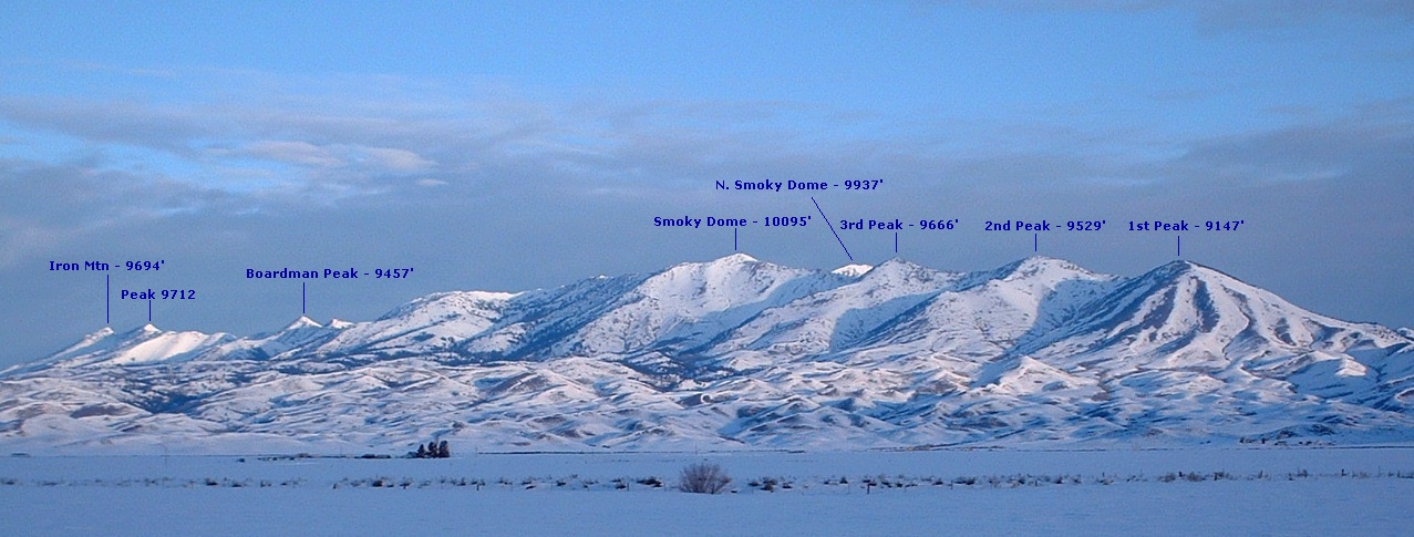
Soldier Mountain Range
Here is a photo of the nearly the entire Soldier Mountain range from the Camas Prairie, just west of Fairfield, Idaho. Each peak has been labeled. Click on the photo for a larger version.