
|
|
Mountain/Rock |
|---|---|
|
|
44.91640°N / 111.4597°W |
|
|
11316 ft / 3449 m |
|
|
Overview
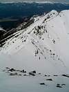
Hilgard peak sits at the southern end of an impressive glaciated uplift. The crest of the Madison Range rises from about 6,500 feet on the shores of Earthquake Lake to 11,316 feet in just over 5 linear miles. Hilgard is the highest in the range, and is the highest point in Montana outside of the rugged Beartooth Range. The sharp glacial horn sits at the head of three large drainages, all of which have been used as an approach at one point. There is no easy way to get to this mountain. The Madison Range, however, rewards climbers for their hard work. While many of the peaks do not stand out from the nearby valleys (in fact, Hilgard cannot be seen easily from any road), Hilgard looms darkly over the large alpine basins to the east.
First climbed as a one day ski mountaineering adventure by Dave Wessel in 1948, Hilgard still sees surprisingly few ascents each year. Set in the largest of the four disconnected units of the Lee Metcalf Wilderness, this peak presents many challenges even before the climbing begins. The Taylor-Hilgard unit of the wilderness is home to Grizzly Bears, black bears, elk, and as of 1999, at least one denning wolf pack. The scenery is breathtaking as well, with large alpine meadows full of shooting stars, marigolds, glacier lilies and mountain bluebells. The trail system is somewhat sparse, which gives visitors a sense of space and openness once above treeline.
 |
 |
 |
 |
Getting There
The Madison Range is situated just Northwest of Yellowstone National Park, between the Madison and Gallatin Rivers, and North of Earthquake Lake. Most trailheads are accessed from US 287 that runs from Ennis to near West Yellowstone. From Bozeman, take US 191 (The Gallatin Canyon) south approximately 75 miles to the junction with US 287 and head west. From West Yellowstone, take US 191 north about 8 miles to the same junction. While there are many ways to approach these peaks once on foot, the three most often used will be outlined here.
West Fork of Beaver Creek
Take Forest Road 985 (Beaver Creek) north from US287 for approximately 3 miles to the trailhead for trail #222. If you pass the small cabin (available for overnight stays year round from the Ranger Station in West Yellowstone), then you have gone ¼ mile too far. Follow this trail southwest along the West Fork of Beaver Creek to Avalanche Lake (about 5 miles). Once there, cross the ridge to the north, off trail, to camping near the small Lake Eglise. The view of Hilgard Peak from the crest of this ridge is stunning. This is a pristine wilderness basin, please use Leave No Trace camping and traveling practices at all times.
Sentinel Creek
Continue on Forest Road 985, past the cabin and Potamogeton Park and Trailhead # 21. This trail follows Sentinel Creek north and then west on trail #202 towards Expedition Pass. This is a fairly strenuous 6-7 miles. Before climbing Expedition Pass, in a spring fed meadow, travel south on trail #201. This trail will take you through an incredible string of alpine lakes, and eventually into the beautiful Hilgard Basin. This is a delicate ecosystem, so please select campsites carefully. If you wish to avoid the roundabout approach up Sentinel Creek, you can also bushwhack up Hilgard Creek to the same basin. This is not recommended.
Papoose Creek
This approach is best used in early season, or winter, when you are assured of good snow cover. From US 287, ½ mile east of the West Fork Rest Area, take the signed road to Papoose Creek (trailhead #26). Follow trail #355 for about 4 or 5 miles until a northern fork of the creek is crossed. Continue on the trail until out of the thick trees, and look for a talus slope on the left. The margin of the talus provides relatively easy hiking or skinning up the headwall and into the basin due south of Hilgard and Point 11,062. Once up the headwall, stay left of the creek. A series of small benches and a spring make for excellent camping.
 |
 |
 |
 |
 |
Red Tape
The Lee Metcalf Wilderness does not require a permit for backcountry travel or camping. No motorized travel within the wilderness. Certified weed free hay is required for all livestock. Reservations and inquiries about use of the Beaver Creek Cabin can be made at the Hebgen Lake Ranger Station in West Yellowstone (Address: P.O. Box 520 331 Hwy 191 N. West Yellowstone, MT 59758 – Phone: (406) 823-6961 FAX: (406) 823-6990 - Hours: Monday thru Friday Summer: June.-Aug. 8:00am - 5:00pm Winter: Sept.-May 8:00am - 4:30pm).
When To Climb
This peak is accessible all year. Beaver Creek may become impassable due to snow, but Papoose Creek is usually dry to the trailhead even in winter. Snow will persist until late June, early July most years. Snow may make the last moves to the summit a bit easier.
Mountain Conditions
Conditions are often hard to come by for places in the middle of nowhere. Hilgard is no exception. The ranger station in West Yellowstone will have some info (See Red Tape Section). You can also try the local climbing stores in Bozeman (Northern Lights: (406) 585-2090 or Barrel Mountaineering: (406) 582-1335). You can also try various internet sources (SummitPost, of course, or Thomas Turiano's Site).
 |
 |
 |
Local History
Earthquake Lake, situated south of the Madison Range, has a sad and interesting story. Around midnight of August 17th, 1959, a magnitude 7.5 earthquake rocked this area. The mountainside south of Madison Canyon came crushing down, blocking the Madison River and completely covering a large and mostly full campground. 28 people were killed when 80 million tons of debris rolled down at over 100 miles per hour. A dramatic effort was made to open the Madison River in order to prevent catastrophic flooding downstream. In 1967 the Forest Service opened the Earthquake Lake Visitors Center to remember those lost and educate visitors. Montana ranks fourth among the 50 states for earthquake activity.