
|
|
Mountain/Rock |
|---|---|
|
|
39.45180°N / 106.1054°W |
|
|
Summit |
|
|
Hiking, Mountaineering, Skiing |
|
|
Spring, Summer, Fall, Winter |
|
|
13195 ft / 4022 m |
|
|
Overview

Peak 9
Peak 9 is the second highest of the numbered mountains of the linear Tenmile Range, near Breckenridge, Colorado. Peak 9 is the first peak in the Tenmile to reach the 13,000 foot mark, and the rest of the range rises quickly through several high 13ers and the 14er Quandary Peak. The lower slopes of Peaks 7-10 comprise the popular Breckenridge ski area. The top of Peak 8 is the actual resort high point. The numbered peaks of the Tenmile are a very linear range of about 9 miles that create a wall of peaks only one mountain wide, towering above the towns of Breckenridge and Frisco.
Peak 9 is a fairly gentle peak, and it is easy to climb via a Class 2 hiking route. Peak 9's summit is also accessible from the summits of Peaks 8 and 10 via and easy ridge. The summit of Peak 9 is a great place to lounge and it has views of the Tenmile, Front, and Gore ranges. The best access is from the Breckenridge Ski Area, and this is a great ski tour and easy descent in winter and spring. Once Breck closes for the season, it's slopes become hiking and mountain biking routes. Peak 9 is a nice, easy hike in summer.
The Numbered Peaks of the Tenmile Range:
| Peak 1 | 12,805 feet |
| Tenmile Peak | 12,933 feet |
| Peak 3 | 12,676 feet |
| Peak 4 | 12,866 feet |
| Peak 5 | 12,855 feet |
| Peak 6 | 12,573 feet |
| Peak 7 | 12,655 feet |
| Peak 8 | 12,987 feet |
| Peak 9 | 13,195 feet |
| Peak 10 | 13,633 feet |
Getting There
Breckenridge Ski Resort
Begin at the Breckenridge ski resort. Your starting point will differ based upon snow and whether Breck is still operating.
Drive to South Park Avenue on the south end of Breckenridge. Turn west and drive 0.2 miles and turn left on Village Road. Drive 0.2 miles on Village Road and turn left into a large parking lot near the Beaver Run complex. Turn left, cross the lot and turn right onto County Road (CR) 751 (dirt). This road leads to the top of the Peak 9 section of the ski area. After 0.5 miles keep left. There is a gated road on the right. Pass a lift and drive around to another intersection near 0.8 miles. Stay right on the main road and begin the climb into the ski area. Near 1.5 miles, stay right. Near 3.0 miles, go under a lift. Stay on the main road and pass the Peak 9 Restaurant. Continue up to the highest lifts near 3.6 miles. This is the trailhead. Past this point, the road is rough and 4WD is required.
In winter and spring while Breckenridge Ski Resort is still operating, you can take the Mercury Super Chair to the start of this route. Above the lift, start up the road. Backcountry access is not always open here, so call the ski patrol to check on the status before you plan a trip. Never duck closed backcountry gates. This violates the Colorado Skier Act, and will get you a hefty fine.
Routes
Click here for skiing options.
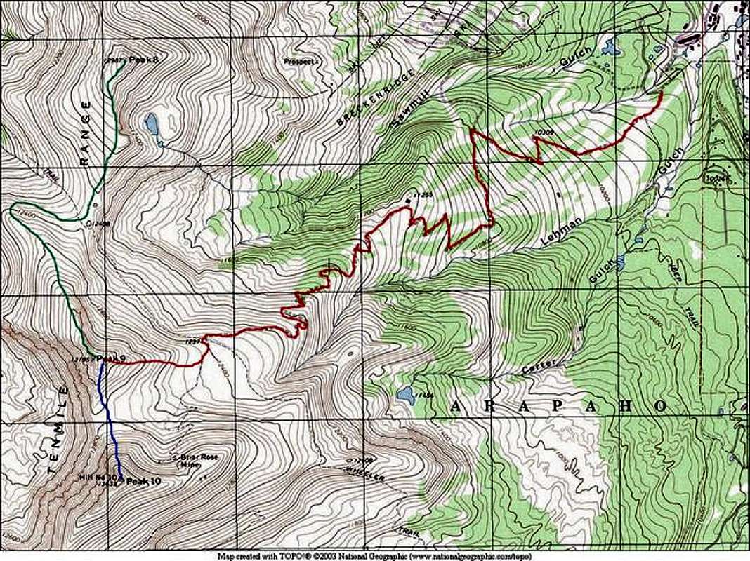
RED=East Ridge via Breckenridge
BLUE=South Ridge via Peak 10
GREEN=North Ridge via Peak 8
Red Tape
There are no fees for anything on this route. As always, obey private property postings. If you travel through Breckenridge Ski Area, obey their rules and directives.
Click here for the Breckenridge Ski Patrol.
When To Climb
Peak 9 can be climbed all year-round. Be aware of Avalanche danger in the winter and spring. Visit the Colorado Avalanche information Center's Website for current information.
Camping
There are no formal campsites in this area.
Peak 9 Weather
Click this link for a high altitude NOAA weather forecast for Peak 9.
Breckenridge Mountain Cams
Click here for the Breckenridge Ski Area Mountain Cams.