
|
|
Mountain/Rock |
|---|---|
|
|
48.27680°N / 120.7651°W |
|
|
8360 ft / 2548 m |
|
|
Overview
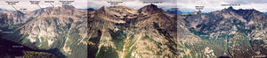
Devore Peak is an important regional mountain in the "Stehekin Triangle" (see the Dark Peak page for an explanation of this triangle). The mountain is located about six miles WSW of the town of Stehekin and is the highpoint of a long north-south ridge dividing Company Creek and Hilgard Creek on the west and Devore Creek on the east. There are four summits higher than 8,200 feet on the ridge--Wy'East Mountain (8,280+ ft), "Wy'North" (Pk 8202), Devore Peak (8,360+ ft), and Tupshin Peak (8,320+ ft). Each of these is among the 200-highest peaks in the state. In addition there is 7,800+ ft White Goat Mountain and its remarkable razorback.The main problem with peaks in this area (with the exception of mighty Bonanza Peak) are that they are quite eroded and lack pleasant rock faces for climbing. (Rock is ancient gneiss.) More so, the approach basins and ridge slopes are often tedious talus traps--you can step onto them but you can't seem to get off of them. Even so, there are modest technical climbs available, if you like "Cascade Choss." Devore Peak is no exception. The two main routes on it are Class 4 affairs (the Southeast Ridge and North Ridge). The West Face is cut by intersecting gullies and is not all that interesting. The Northeast Face, on the other hand, has some character or at least compells the eye from below. However, from the summit, the face looked more haphazard and lacking of climbing lines. All in all, in terms of fun climbing, you could say Devore is devoid. But the mountain is among the Washington Top 100 so is an objective for those pursuing that list. In fact, purusing the summit register reveals mostly the same old names I've read on all the other obscure Top 100 peaks. Our climb on May 28, 2005 was supposedly the 24th ascent party though it is entirely possible some have not signed in. The register is the original one from the first ascensionists in 1940 (Everett and Ida Zacher Darr).
 |  |  |  |  |
Getting There
Note that Devore Peak is often combined with nearby Tupshin Peak for the Top 100 afficianados. White Goat Mountain between the two is also a "popular objective" for those afficianados who are also ordinary peakbaggers. All three peaks require technical gear. All three can be climbed from the same camp at 5,800-ft in the Bird Creek drainage or from a camp on the Devore Creek Trail called "Bird Creek Camp" on the GreenTrails map.
The approach to this peak will take longer than the climb, probably. But if you're wise to shortcut procedures, you could save time. First of all, you need to find yourself in the town of Stehekin. See the Getting There section on the Dark Peak page for the specifics.
Take the $5 shuttle bus (or catch a ride or ride a bike or walk it) from Stehekin Landing 4.4 miles up the road to Harlequin Bridge (rust-colored). Cross the bridge and continue for 300 yards, going past the Harlequin Camp road on the left to a wye. Go left at the wye and follow the road around past the town maintenance yard to the Stehekin Airport (grass airfield). Follow a dirt track southeastward on the east side of the airfield to its corner. The Stehekin River Trail more or less starts here. It first crosses on boardwalks over marshy ground to the other side of the airfield to a trail junction. Go left at the junction and follow the mostly flat trail southeastward for 3 miles to the signed Devore Creek Trail junction (1,160 ft). This junction coincides with the short trail continuance to Weaver Point on the shores of Lake Chelan.
Special note: If you take a float plane to Stehekin you can arrange to be dropped off at Weaver Point thus saving 3.7 miles of flat valley walking to get from the Stehekin River Road to the start of the Devore Creek Trail. The only stipulation is that your party size on the plane has to be least two people.
Devore Creek Trail
The trail first ascends in 30-something switchbacks in approximately 2 miles to reach the Glacier Peak Wilderness boundary at 2,300 ft. I'm referring to the point where you come upon the wilderness sign, not the supposed boundary as shown on maps. After that, with a brief respite from the up, you'll be thinking your work is done for the day. But, ah, not so.
For the next 3+ miles the trail climbs up and up and up, never easing off. To make matters worse, the trail does not see much traffic and is therefore brushy in the middle third. It's never hard to follow just that the encroachment from the sides adds to the insulting incline. Your imprecations would be even louder if the brush were wet too.
As a helpful hint, if you can manage it, do the trail in the late afternoon when the sun has descended behind the mountain slope. It's a grind and who needs the thermal truncheon above you adding to your woes?
Finally, at about 4,100 ft, the trail enters significant timber beyond a creek (the creek draining the east side of Tupshin). Shortly thereafter the trail reaches Bird Creek at 4,200 ft. Bird Creek Camp is about 50 yards before the creek crossing. It is the ONLY designated camp in that area of trail. There is space enough for three tents + a cook area.
From Harlequin Bridge, allow for 4 hours to get to Bird Creek Camp.
North Ridge
See the North Ridge route page.
First recorded ascent: Steve Ricker, Steve Fry, and David Singleton in September 1987. A climb of this ridge or some facsimile thereof may have been the route of the first ever ascent of the peak (the Darrs). Also, Bob Nielsen and partner also apparently climbed the North Ridge in the 1980s. It should be noted that a good portion of the route actually takes to ledges and gullies on the west flank.
 |  |  |
Red Tape
There is no red tape for this part of the Glacier Peak Wilderness. Leave No Trace ethics should be prescribed to. This would include red tape or green tape or yellow tape or orange tape or multi-colored striped tape to help guide your way back through the brush. DON'T FLAG ROUTES THROUGH OR AROUND BRUSH!When To Climb
Devore Peak can be reasonably climbed from May to October. In early season, snow may amply cover brush in lower Bird Creek. (The steep sidehilling on the Devore Creek Trail could be a problem if snowcovered.) Moreover, the brush will not have leafed out thereby affording long sightlines through it. The final ridge scramble to the summit could be dicey in early season if there is a lot of snow. Cornicing should be expected. The rock step just before the summit may or may not be harder with snow on it. Enough snow in early season may fill the notch at the base of the step high enough to give you a boost up the hardest part. As the summer progresses there will certainly be less post-holing in snow but the scree and talus--especially on the outlying East Ridge--will make you sore. Bugs will be more of a problem in the heat of summer. All told, I think June would be most excellent.Camping
Several Campsites are available off of Stehekin Valley Road. The most useful one for late arrivals would be Harlequin Camp just across Harlequin Bridge. Weaver Point also has campsites. Other than that, you'll want to either camp at Bird Creek Camp on the Devore Creek Trail (4,200 ft) or carry the weight of all that heavy overnight gear to the middle basin of Bird Creek (5,800 ft). I think the latter is a waste of time and energy unless you'll be in a blazing hurry on summit day. That is, if you want to climb both Devore and Tupshin on the same trip, you cannot really do them both in a day (or you maybe could if you're extremely fast). You could do Devore and White Goat in one day or Tuphsin and White Goat in one day, though. Furthermore, a shortcut route to Tupshin from Bird Creek Camp that does not go up Bird Creek can be used.Mountain Conditions
Localized ForecastStehekin Forecast