
|
|
Mountain/Rock |
|---|---|
|
|
37.87820°N / 119.0072°W |
|
|
9172 ft / 2796 m |
|
|
Overview
"A country of wonderful contrasts, hot deserts bordered by snow-laden mountains, cinders and ashes scattered on glacier-polished pavement, frost and fire working in the making of beauty."
Thus described John Muir the Mono Basin during his first summer in the Sierra Nevada.
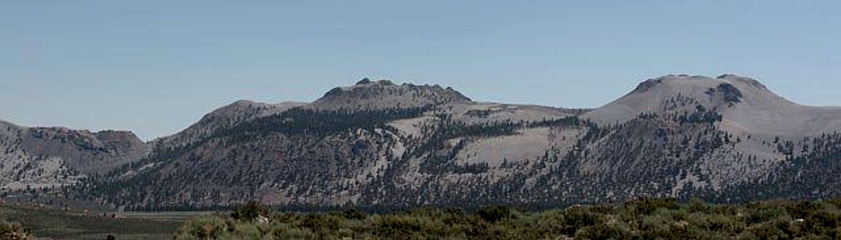
Dramatic, unique, aesthetic, & noticed by all traveling Route 395 south of Mono Lake, Crater Mountain and the rest of the Mono Craters (of which Crater Mountain is the highest), are at once obvious landmarks as well as enigmas. Despite the buttes’ prominence, Mono Lake & the huge peaks of the Eastern Sierra, rising over 6,000 feet above Mono Lake (compared to the Mono Craters’ 2,400’) take center stage around here, effectively relegating Crater Mountain & the other Mono Craters to a secondary status. Few of the hoards of people passing by would be able to name Crater Mountain, much less be able to relate any facts about it, though many would recognize its form.
The Mono Craters are the youngest mountain range in North America: Eruptions were going on here 40,000 years ago, & most of what today is visible as the Mono Craters was formed within the last 10,000 years. The most recent eruption was that of Panum Crater, some 630 years ago. Crater Mountain, as well as most of the Mono Craters, consist primarily of pumice and obsidian. Israel Russell, the noted geologist after whom great Mt. Russell was named, wrote an extensive report on the Mono Craters. Check it here.
Due to the overwhelming number of other spectacular outdoor features of the area, the Mono Craters are often overlooked by recreationists. As a result, Crater Mountain offers welcome seclusion seldom found in the Sierra Nevada (I saw not a single person while on the mountain while there!). Given this seclusion, the ease of the approach & short climb to the summit, the unmatched views of Mono Lake, the Tioga Pass-area Eastern Sierra peaks, & Nevada Great Basin ranges, one could hardly ask for a better half-day excursion. Perhaps the most appealing thing about Crater Mountain, however, is its proximity (only 11.1 mouth-watering driving miles away!) to the world-renowned Whoa Nelli Deli (official site; summitpost page). A mango margarita (&/or fish tacos, …) here is the perfect post-climb reward.
 |
Mono Lake
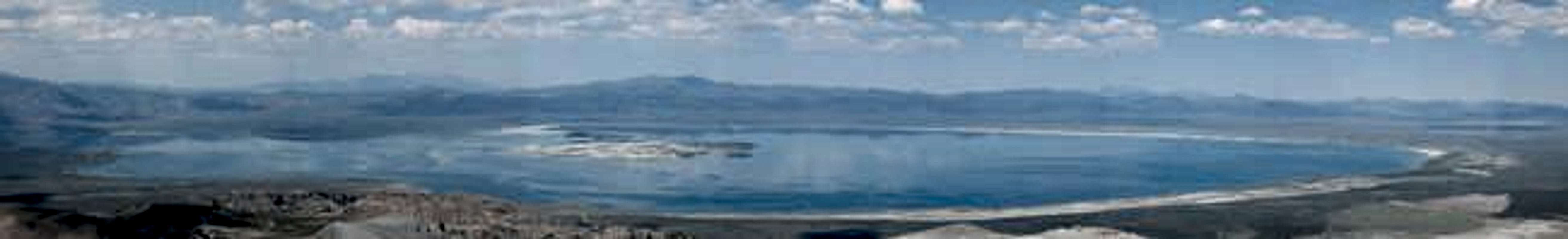
Perhaps the greatest natural feature in the area, sharing a name with the Mono Craters, is… you guessed it- Mono Lake!! Check out monolake.org for more info’. Many people have admired its serene, silvery waters from afar while en route to other destinations. For those not already familiar with this striking feature, Mono Lake is considered the oldest lake in North America. While fed by clean streams coming from the Sierra Nevada, it is highly saline and alkaline due to the composition of the lake bed. In addition to its beauty, it is reputed to clean soiled garments very efficiently (then you just have to wash them again to remove the lake’s salt).
The lake’s residents
Mono Lake is host to almost 2,000,000 migratory waterfowl annually, & it is estimated that it is the birthplace of 80-90% of California’s gulls. Birds particularly dig Mono Lake because in the absence of fish predators (fish don’t really get along with the extremely alkaline environment Mono Lake offers), there is an abundance of ‘food’ in the form of tiny brine shrimp & funky (but harmless to humans) alkali flies (a moving black carpet, if you ever walk around the shore there) for them to scarf down. Perhaps surprisingly, the Mono Basin Paiute ate these alkali flies as well.
Additional Mono Basin birds beta
One fo’ the money, tufa the show
One of Mono Lake’s most interesting features is the fonkay tufa (pronounced ‘too’ fa) towers that rise dramatically above the lake in numerous places. These towers are formed when calcium from underwater springs encounters carbonates in the water. Their height is actually an indicator of the lake’s former height/depth (they form underwater). You thank the unquenchable thirst of The City of Los Angeles for the tufa towers' visibility- without depriving the lake of its incoming water for many years, easy examination of the tufa towers as we know it would not be possible! Check out this link for more beta on the tufa. One of the best places to view these is the South Lake Tufa center (call the Mono Basin National Scenic Area Visitor Center for times of free tours), reached by continuing on 120 E for approximately another 2 miles beyond the turnoff for Crater Mountain (follow the signs). Recommended is going there to catch a spectacular sunset at the lake among the towers, beneath the High Sierra.
More valuable than gold
God never intended Southern California to be anything but desert...Man has made it what it is.
- Carey McWilliams, pre-eminent historian of the southland (1946)
The Los Angeles metropolitan area, one of the United States’ largest, would not be what it is today were it not for supplemental water sources. Engineering marvels such as the LA Aqueduct (The City completed the First Los Angeles Aqueduct in 1913 to import water from the eastern slope of the Sierra Nevada, some 250 miles to the north. The second one was built in 1970, increasing the system’s capacity by 50%), as well as the Colorado River, have all contributed greatly to LA’s water demands. While it would be impossible to use Mono Lake’s less-than-palatable saline & alkaline waters as a viable water source, its tributaries, carrying pristine water from high in the Sierra, were rightfully deemed excellent sources. The Los Angeles Department of Water and Power began diverting Mono Lake’s tributaries for the benefit of Angelinos in 1941 (411). Mono Lake was rapidly on its way to becoming another Owens Lake, its volume being halved & salinity doubled due to the aforementioned diversions- things were not looking good. Majorly bummed by what was happening, David Gaines formed the Mono Lake Committee in 1978 and began talking to conservation clubs, schools, service organizations, legislators, lawyers and to just about anyone who would listen, about the value of this special high desert lake. Under the leadership of Gaines, the Mono Lake Committee eventually grew to 20,000 members and gained legal and legislative recognition for Mono Lake. In 1978, a law suit by the Mono Lake Committee, National Audubon Society and others challenged Los Angeles' diversion of this water, claiming that fish, riparian habitat and Mono Lake's ecosystem were not considered when the diversions were begun.
After many legal battles, the Mono Lake Committee won a major victory with the passage of Mono Lake Basin Water Right Decision 1631 (Decision and Order Amending Water Right Licenses to Establish Fishery Protection Flows in Streams Tributary to Mono Lake and to Protect Public Trust Resources at Mono Lake and in the Mono Lake Basin) on September 28, 1994, by the State of California Water Resources Control Board. Decision 1631 set permanent streamflows for Mono Basin streams and a lake level of 6,392 feet to protect Mono Lake's public trust values, as ordered by the California Supreme Court. The ending lake elevation afforded by the decision is still 25 feet below Mono Lake's pre-diversion level of 6,417 feet, but is expected to restore many lost public trust values and prevent future degradation of resources. The lake level is currently still rising, and should continue to do so for another decade or two until it has stabilized to the elevation mandated by Decision 1631.
More beta.
Those interested in LA & its related water rights issues might enjoy Cadillac Desert by Marc Reisner (1986; ISBN 0140178244), a detailed account about land development and water policy in the western United States. A PBS miniseries (synopsis) was apparently also made based on the book. Thanks to Dean for this suggestion!
The Mark Twain Connection
The irrepressible Mark Twain spent time around Mono Lake as well (described in chapters 38 & 39 of Roughing It), referring to the “unpretending expanse of grayish water” unflatteringly as “this lonely tenant of the loneliest spot on earth.” Both the local Native Americans & American hotel clerks are also referenced in an equally uncomplimentary fashion in these writings. Fans of Twain’s wry wit will not be disappointed as various of his experiences in the area are suspensefully related in the manner typical of his style. Thanks for this link provided by East Side resident Clydascope!
Getting There
* note 1: those attempting to approach Crater Mountain using the directions below should be aware of the deep sand that comprises much of the roads described- beware, lest your vehicle get stuck (perhaps even bring some boards to put under your tires just in case)!!** note 2: if desiring to climb any of the Mono Craters during any other times than summer or fall & coming from the Bay Area, ensure that Highway 120 is open over Tioga Pass (closed from late fall until spring/summer) by calling 800.427.ROAD; otherwise a lengthy detour must be made from the north)*
If you are clever (or read the Overview section), you might have guessed that Crater Mountain, as one of the Mono Craters, lies in the vicinity of Mono Lake. This guess would be correct. Directions for getting there will start at the 395-120 E split (4.7 miles S of where the 120 runs into the 395 coming from Tioga Pass, and whatever the distance is from Mammoth (Bishop, etc.) to the 120W-395 split minus 4.7 miles). Reset your tripmeter to 0.0 here (395-120E junction). Proceed E towards Benton, Nevada. Before you get there, specifically at 3.0 mi, take a R onto a dirt road (a sign at this 4-way intersection should indicate “Panum Crater” to the L).
Shortly after you turn a sign should proclaim “1N11.” Proceed, & stay on the R-hand fork at 4 consecutive road forks (the first is at 3.1 miles where there is a sign reading “RESTRICTED AREA- VEHICLES PERMITTED ON DEVELOPED ROADS ONLY;” the 2nd and 3rd are both at 4.1 mi (about 100’ apart from each other); and the 4th is at 4.2 mi, where a sign between the forks details information on Off Highway Vehicle (OHV) usage around the Mono Craters.
Go past another 2 road junctions, this time staying to the L both times. The first junction is at mile 4.8, with a sign shortly thereafter reading “1S03.” The second junction is at mile marker 5.0, where another sign indicates “Restricted Use Area, Vehicle Use Restricted to Roads.”
Keep going- you’re almost there! Continue on the road- this stretch of road is arguably the most challenging, especially for low clearance, 2WD cars. The centre of the road is frequently quite high (for a regular-clearance vehicle) here, & is composed primarily of sand, which can be quite deep in places. For sections that appear to be deep sand, uphill, or both, make sure you have enough momentum to keep you going through the sand (i.e. not getting stuck in it)!
A large clearing that I could imagine has trapped its share of unwary drivers’ cars can be used for parking on the R-hand side of the road at 6.0 miles (this would also make a good campsite, were car camping allowed here). Another pullout (again on the R) comes shortly afterwards, and what seems to be a ‘designated’ parking spot (room for 1 vehicle) is on the left side of the road, at 6.2 miles.
The ‘trailhead’ lies approximately 50 ft beyond this ‘parking spot’ at 6.2 miles, on the R-hand side of the road, right as the road makes an obvious turn to the left. Look for footprints going through the brush up the hill.
 |  |
Red Tape
While Crater Mountain lies within the Mono Basin National Forest Scenic Area, the first of its kind, the full extent of the protectoral status & restrictions that this title represent are mysterious and not fully apparent. While the Mono Basin National Forest Scenic Area Visitor Center phone message specifically mentions that wilderness permits are required for overnight stays in the Hoover, Ansel Adams, & John Muir Wildernesses, one is left to assume that the areas not belonging to these do not require them. Talking to an actual person, however, the following restrictions are imparted:· No vehicle camping (“car” camping) allowed- a permit must be obtained at The Mono Basin National Forest Scenic Area Visitor Center to camp at the Mono Craters, where the campsite must be reached by either hiking or paddling in.
· A fire permit is required for both campfires and stoves. This area is extremely dry (it is a desert), there is a fairly substantial amount of vegetation on the mountain’s lower slopes, and there might be wind- all of these factors combined make for ideal wildfire conditions- be responsible!
One of the few restrictions mentioned explicitly during the actual approach (the others are found out seemingly only if explicitly contacting the Visitor Centre & inquiring) is that regarding Off-Highway Vehicles (OHVs, for those of us not in the know)- signs en route state such things as “Restricted Use Area- Vehicle Use Restricted to Roads” & “Restricted Area- Vehicles Permitted on Developed Roads Only.” Most people will be content testing their off-roading skills on the sand pit ‘roads’ that must be traveled just to get to the base of the mountain. The sensitivity of this fragile environment seems obvious.
When To Climb
Climbing Crater Mountain need only be a half-day affair (if that) for those in decent physical shape. An ascent would be ideal for Bay Area Eastern Sierra peakbaggers returning home with half a day (or potentially just a few hours’) free time. The best seasons would be spring through fall.While the amount of winter snow accumulation on Crater Peak & the Mono Craters is unknown, the upper treeless slopes should definitely be suspect of potential avalanche conditions during times of snow instability. Call The Mono Basin Scenic Area Visitor Center should you have any questions. During the summer, be mindful of thunderclouds near the summit, as Crater Mountain is the highest point in the immediate area, & descend immediately if you hear thunder or see lightning nearby.
Camping
No vehicle camping (“car” camping) is allowed around the Mono Craters. Obtain a permit at The Mono Basin National Forest Scenic Area Visitor Center to camp at the Mono Craters, where the campsite must be reached by either hiking or paddling in. Weather permitting, camping amidst the lunar landscape of the summit plateau/crater would be sublime, with amazing views of Mono Lake, the Great Basin ranges of Nevada, & the High Sierra.Designated campsites nearby also include those in Lee Vining Canyon headed towards Tioga Pass and around Mono Mills.
Mountain Conditions
· 395.com weather forecast for Mono County (go to the L-hand side of the screen & click on Weather Report, Mono County Forecast)· weather.com forecast for Lee Vining (right down the road from the Mono Craters)
· For detailed conditions call The Mono Basin Scenic Area Visitor Center.
Summit Views!
Summit views atop Crater Mountain are absolutely stupendous. A great deal of the Yosemite-area High Sierra is visible, from Mt.s Ritter & Banner Peak in the south to Dunderberg Peak in the north. Some of the Eastern Sierra Peaks visible include Mt. Ritter, Banner Peak, Mt. Gibbs, Mt. Dana, Mt. Conness, & Dunderberg Peak. Mono Lake is also an obvious show-stopper, directly below the Mono Craters. Montgomery Peak in Nevada is also particularly prominent to the east. One obviously has the perfect view of the lunar landscape that composes the Mono Craters themselves. |  |  |
Mo' beta
· Mono Craters Madness· The Obsidian Trail (find in alphabetical list in link & click), a fascinating documentary on the role of Obsidian in the prehistoric Owens Valley & the peoples around at that time (some sweet aerial views of the Eastern Sierra, Inyo & White Mountains, & Mono Craters, too!)
· 395.com page to the Mono Basin National Forest Scenic Area:
· The Mono Basin National Forest Scenic Area Visitor Center:
Open daily in the summer; hours vary during winter months. Call 760.647.3044.
· Mono Basin Scenic Area Visitor Center (open until Labor Day ‘5 daily from 9.00 until 16.30):
P.O. Box 429, Lee Vining, CA 93541
(760) 647-3044, TTY: (760) 647-3045.
· “forest recreation & wilderness information:” 760.873.2408