

-
 34761 Hits
-
 91.75% Score
-
 36 Votes
|
|
Mountain/Rock |
|---|---|
|
|
47.05416°N / 9.70741°E |
|
|
Hiking, Mountaineering, Via Ferrata, Skiing |
|
|
Spring, Summer, Fall, Winter |
|
|
9725 ft / 2964 m |
|
|
Overview
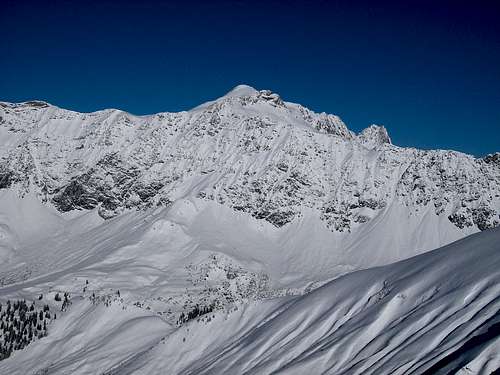
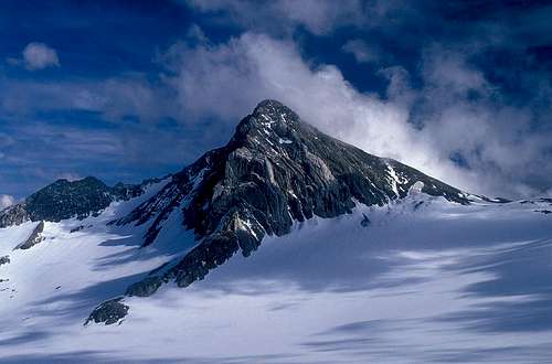 Mathias Zehring - Schesaplana above Brandner Glacier
Schesaplana is the highest peak and most visited mountain of Rätikon, a beautiful, small group in the Alps on the borders of Switzerland, Austria and Liechtenstein. It is primarily a mountain for experienced hikers, unlike many other mountains in the area, which, besides easy trails to the summit, also offer some of very hard routes. The faces and ridges of Schesplana are wild too, but there are not many established long climbing routes. In winter and spring, it is also a fine ski touring goal. The summit lies on the main ridge of Rätikon, which stretches predominantly in the east-west direction. The ridge has many more summits, rocky spurs and wild ridges in all directions, but despite the rugged terrain, there are hiking trails across some high passes. Two of those close to Schesaplana are the Schesaplanasattel, 2739 m, about 700 m to the WSW, and Gamsluggen, 2383 m, about 2 km to the SE.
 Zirmenkopf
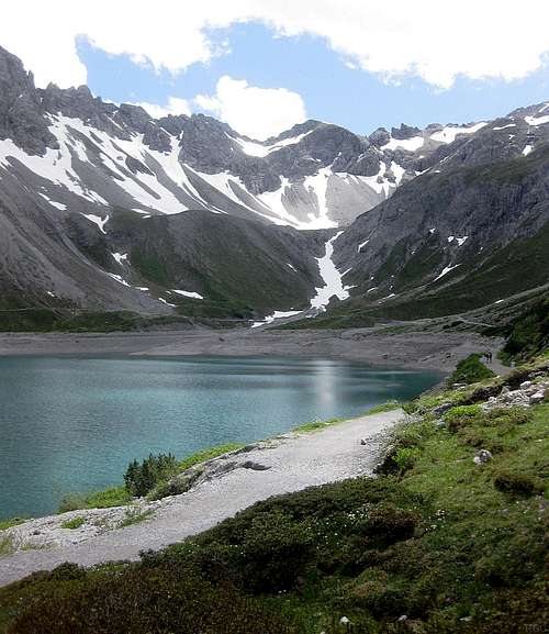 Gamsluggen from the Lünersee: there is a hiking trail going over that ridge!
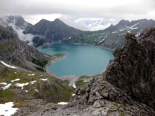 And here is the opposite view: The Lünersee from Gamsluggen
 From the summit a long and rugged ridge extends to the NE, first culminating in the Felsenkopf, 2835 m, then Zirmenkopf, 2806 m, after which it splits into two branches, a long one to the north and another one to the east, to Seekopf, 2698 m. To the north and northwest of the main summit, and some 300 m lower, stretches the small Brandner glacier. It is rather flat, easy to cross and crevasse danger is relatively small. On the eastern side of the mountain lies the Lünersee, one of the largest lakes in the area. However, it lies at an elevation of 1970 m, so don't expect warm water.
The summit can be reached from all sides. The easiest and most frequented route comes from the east, using the cable car to the Lünersee. Many other routes from the SW, W and NW (over the Brandner glacier) join just below the summit on Schesaplanasattel, 2739 m. The popularity of the mountain is shown also by the fact that there are no less than five mountain refuges within easy distance, supporting all sorts of outdoor activities. In summer, the Brandner glacier offers opportunities for easy tour skiing - as long as the glacier withstands the pressure of global warming.
Geology
As the western Raetikon summits geologically belong to the Northern Limestone Alps, also Schesaplana is made of triassic limestones and dolomites. Only around the very summit some younger (jurassic) limestones can be found.
Summit Views
Needless to say, being in the middle of the Alps and the highest in the group, Schesaplana offers a great panorama. On a clear day, the views range from the faraway Wallis Alps over the Bernina and Ortler groups to the Ötztal Alps, and a thousand more peaks closer by.
 Click to run this one online |
The first recorded ascent of Schesaplana was already in 1610 by David Pappus, Christa Barball and Claus Manall, which makes it one of the earliest recorded ascents on one of the main summits of European Alps.
Show a bigger map
Getting There
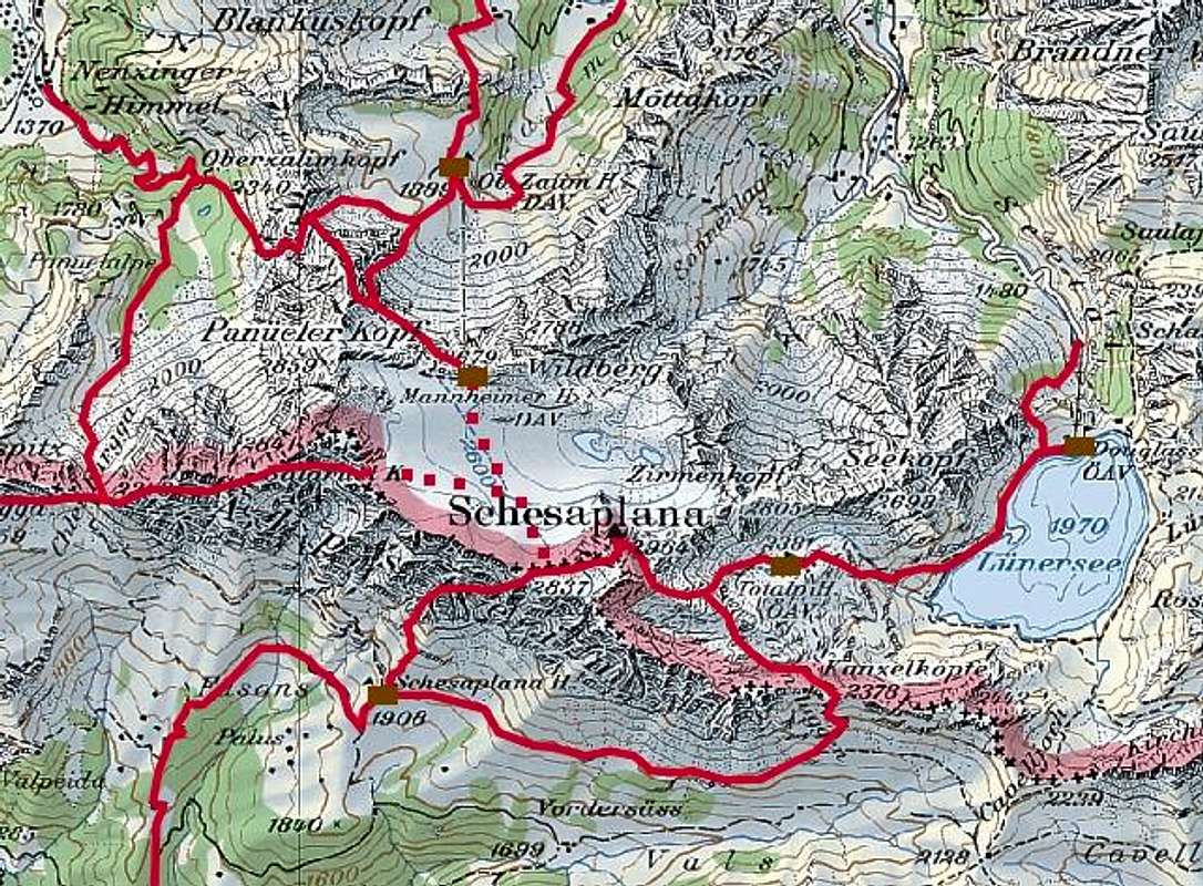
From the north, from the Austrian side, the main road goes from Arlberg pass (East) down to Bludenz and further on to Feldkirch. From Bludenz you can drive through Brandner Tal towards the S and SW to Brand and further to the big parking place of the Lünersee cable car, 1566 m. By the cable car (or by a good, marked path below it) you reach the upper station at Lünersee dam, 1980 m. The Douglashütte is also located there. If you travel by public transport: Bludenz has a train station, and from there you can take a public bus to the parking lot of the Lünersee cable car The other valley from the N is Gamperdonatal. The road through that valley is closed for public traffic, but in Nenzing, a few kilometers west of Bludenz, you can get a Jeep-taxi, which brings you to Nenzinger Himmel, 1370 m. Nenzing also has a train station.
From the south, from Switzerland, you can reach Rätikon by the highway Chur - Liechtenstein. In Landquart deter east on a regional road for a few km and soon, just before Grüsch, turn north to Seewis, 947 m, where the public road ends (a private road continues much further though).
Maps. Swiss land maps: LK 1:25.000 Nr. 1156 Schesaplana LK 1:50.000 Nr. 238 T Wanderkarte Montafon You can see a detailed Austrian on-line map on: http://www.austrianmap.at/, and a good Swiss map in any resolution on Swisstopo.
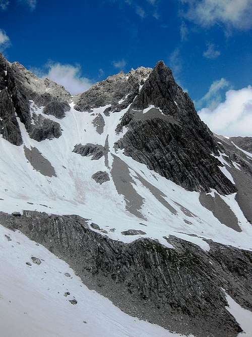
Routes Overview
Schesaplana and some of its (marked) hiking routes
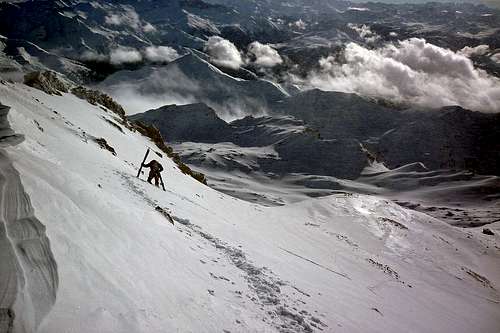
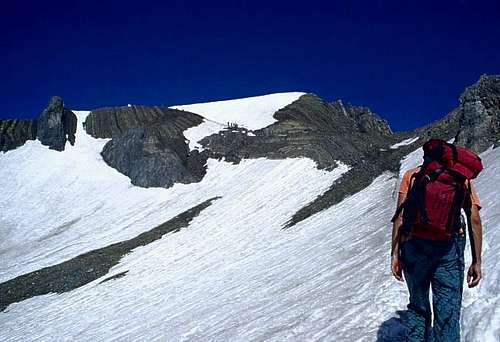
1. The Liechtensteiner Höhenweg - a long-distance hiking path, with a few places where you'll want to use your hands, roughly follows the main ridge. You can reach the main ridge and the path from Nenzinger Himmel, 1370 m (Jeep-taxi from Nenzing), then follow it to the Schaflochsattel, 2713 m and either over the Brandner glacier or directly via the ridge to the Schesaplanasattel, 2739 m and from there to the summit. In fog take care on Brandner glacier (you can expect a good trail in in summer).
2. From the NW, from Mannheimer Hütte, 2679 m. Cross the Brandner glacier to the SW summit ridge at Schesaplanasattel and from there to the top. 1 h 30 min. Again, in fog take care on Brandner glacier.
3. From the SW, from Schesaplanahütte, 1908 m. One ascent goes from the hut towards the east , then up on the main ridge, which is reached on Gamsluggen, 2383 m, then across the totalp plateau towards the NW again. Below the summit, this route joins the route from Totalphütte. The route is a medium hard hike, it requires some mountaineering experience. Take care on Totalp plateau in fog! 4.5 h. The other option from Schesaplanahütte is over the Schweizerweg. Early in the season, when there is still a lot of snow on the mountain, this is more difficult, but later on it's about the same. The warden at the Schesaplanahütte will know the current route conditions. 3 h. Schesaplanahütte is also a fine mountain bike goal. From Seewis, 847 m, ride up all the way to the refuge via Alp Fasons, 1778 m. First on a good asphalt road (closed for public traffic), later on a dirt road, through nice forests and along crystal clear mountain creeks. 11 km to the hut.
 High on the eastern route
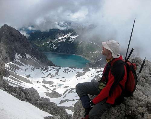 High on the eastern route, looking down to the Lünersee
4. From the east, from Douglashütte and Totalphütte. From Douglashütte go along Lünersee, then up by a well used trail to Totalphütte. From there, head towards the west and finally over the southeast summit slopes to the top. From Douglashütte 3-3.5 h, from Totalphütte about 2 h. Because of the cable car this is the most visited route to the top. It is also a nice ski tour.
Other Places To See

Lünersee
The Lünersee is a beautiful big alpine lake. It looks artificial because of its big dam, but it's not. According to Klaus's information it is situated in a large glacial basin. Before dam construction the lake was about 112 m deep and the largest natural high alpine lake of Austria. In the mid 50´s a dam increased the lake volume and pushed up the lake level by 27 m. The 232 megawatt power station, which uses its water, is in Latschau above Tschagguns, its regular working capacity is 371 million KWh.
Red Tape
No limitations.
When To Climb
The summit can be reached virtually any time of the year, but in winter ascents are long. For summer ascents the best months are mid June to October.
Accommodation
 Totalphütte
- Douglashütte, 1976 m, 170 places, open June to October. Tel.: 0043/5559/206. Approach: From Brand, drive to the cable car parking lot, 1566 m. Take a cable car or hike by a good path (over Böse Tritt), 1 - 1.15 hours.
- Totalphütte, 2381 m, open from mid June until mid October. From the upper station of cable car you can reach the hut in 1 - 1.5 hours.
- Oberzalimhütte, 1889 m. It stands above Brand, half way to the Mannheimer hütte.
- Mannheimer Hütte, 2679 m, 126 places, open from July to the end of September. Tel.: 0043/663/50278. The hut can be reached from Brand (marked path) or from Nenzinger Himmel (marked too (?), a little harder).
- Schesaplanahütte, 1908 m, 100 places, open June to mid October. Tel.: 0041/81/521163, mobile: 41 79 647 6680. From Seewis a 4 h walk.
 The summit view
rgg - Mar 21, 2013 5:39 pm - Hasn't voted
The Totalphütte opens mid JuneLast year, I arrived on 26 June and had a pleasant stay there. Before going, I had asked ahead and learned they where indeed already open for business. According to their web site, in 2013 they open on 15 June, so I reckon that mid June is normal.
Vid Pogachnik - Mar 21, 2013 7:00 pm - Hasn't voted
Re: The Totalphütte opens mid JuneThanks for info! I put it on Schesaplana page. By the way - if you want to have editing or admin rights I'm happy to grant them to you. Cheers! Vid