
|
|
Mountain/Rock |
|---|---|
|
|
39.00950°N / 106.4982°W |
|
|
13758 ft / 4193 m |
|
|
Sayres Benchmark Overview

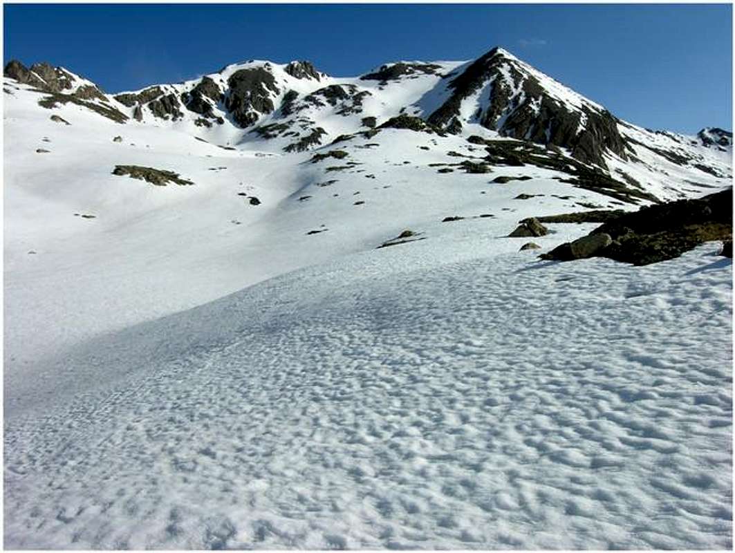
A "real" mountain should mean it's a beautiful mountain, and the real Sayres BM is nothing short of the appropriate and descriptive word “beautiful.” En route past the historic ghost town of Winfield, Colorado, it won’t take long to realize what mountain lords the North Fork of Clear Creek Drainage.
Located 2 miles southwest of Colorado’ fifth highest mountain, Sayres Benchmark measures up well to the higher and more popular, La Plata Peak. The mountain is unofficially named, however it is named on the USGS Independence Pass Quad as Sayres Benchmark (BM). Using the 300-ft criterion, Sayres BM has no trouble establishing itself as a hard ranked, singular mountain. Three major ridges parting from its 13,758-ft summit further validate a hard ranking status. Each of these three ridges includes an 800-1000-ft drop before connecting to another mountain.
Sayres BM hosts two very aesthetic features; its skinny, sweeping east ridge and its rugged north face. The east ridge flaunts a 1000-ft drop and quickly becomes La Plata’s southwest ridge, the same ridge that harbors the 14ers popular Winfield Route. The nasty north face of Sayres is clearly visible from La Plata’s standard Northeast Ridge Route and harbors the beautiful North Face Couloir Route.
I’m not really sure what the standard route is on Sayres BM, but we selected a route that logistically made sense for a snow-laden month of May, the Southwest Face Route. Remember, the south, southeasterly facing aspects of this mountain range really gets blasted with early spring sun providing for a faster melt-off. In April/May locating dry, snow-less, routes on north side of the valley should be easy in the Clear Creek Valley. Our first choice was an ascent of the east ridge, but we showed up about two weeks early. The upper southwest face was still plastered with steep snow, and the cliff ridden run-out beneath that face couldn’t be worse. A slip on that east ridge route would certainly qualify as a real bad experience.
Getting There
Take Chaffee County 390 west from Hwy 24 (15 miles north of Buena Vista, 19.3 miles south of Leadville.) County 390 is an improved dirt road for all vehicles. Continue 11.8 miles on 390 until you reach the historic mining town of Winfield. The road will fork here; turn right and do not turn left and go over the bridge over Clear Creek. The road becomes a high clearance road immediately. Go .33 mile to the old Winfield Cemetery and continue another 2 miles where the road will fork. The right fork is the Winfield TH for La Plata Peak. Go straight, and continue about another mile where the road ends with a gate and a TH sign-in register for the Upper North Fork of Clear Creek Trail. This is also the starting spot for the southwest Face Route on Sayres BM.Mountain Conditions
Click image to enlarge
Click here to view a 7-day forecast for the area surrounding the historic mining town of Winfield

San Isabel National Forest-Red Tape
USGS 7.5 minute quadrangle: Winfield
Trails Illustrated #129 Buena Vista/Collegiate Peaks
2015 North Poplar - Leadville, CO - 80461
Phone (719) 486-0749
Fax (719) 486-0928
When To Climb
The Southwest face Route is a good route for a late April/May ascent of Sayres BM. With consolidated snow, the basin below the southwest face of Sayres will travel fast. Without the snow, you’re looking at a few miles of talus hiking along with a 1000-ft slog up more talus to the summit. The southwest face sets up nice in May for a fast snow climb of moderate steepness to the summit of Sayres. There will be some nasty tree snow to deal with at the start of your day, however, with some perseverance and good route finding you will get above tree line. Bring snowshoes, an ice ax and crampons for this routeCamping
Free camping is available along County 390 from highway 24 to the 4wd trailhead. There are no formal campgrounds on 390, just primitive campsites, and many of them. Many have fire rings and are near a creek. There are abundant places to car camp along 390 as well as plenty of space at the 4wd trailhead.gg
Didn't make it to the Twin Eagles TH this morning. The drive out to Jefferson was a little spooky. At times it looked like I was driving on verglass. Plus there's sections of 285 that are not well lighted and combining that with my scense of icy road made for bare knuckle driving. Descending from Kenosha I encountered blowing snow. After turning left onto the hard snowpacked rd-77 the blowing snow increased in velocity. The sun was barely beginning to show when two cars drove by me flashing there headlamps. I assumed they thought I was driving too fast for the conditions so I slowed down. Two minutes later, doing about 30mph, I suddenly saw what appeared to be a bank of snow blocking the entire road. My first thought was this is where the snowplow stopped plowing the road. I put my breaks on and it was too late. They locked up on the hardpack and I went flying into the 3-ft wall of snow in my Toyota Camry; I suppose I was doing 25-mph after breaking. I remember my car somewhat launching up and landing on top of the snow bank and coming to a stop about 25-30 ft in. I knew instantly that I was going to be stuck. I also knew I wasn't hiking today. The force of impact wasn't bad and I didn't fear that anything with my car was damaged. Now I know why cars were flashing their lights.I gathered all my hiking gear and begun to think about how the hell I was going to dig out. I wasn't happy but I felt good to be alive and my adrenaline was pumping, so I was very focused. At least I had gear to be out in the blowing snow and I had something to dig with. I was happy to have my snowshoes. I got out and began digging. The snow was highly packed and compacted under the carraige of the car. I knew it was going to be a long dig. Again, i was happy to be alive
Suddenly I saw a truck driving in on the opposite side of the bank of snow. A BIG truck with BIG wheels and a lift kit. They stopped, got out and surveyed my situation. He asked if I needed a tow. I felt lucky having only to dig for 5-10 minutes before I met a dude with a heavy duty truck with a chain.
We agreed that the snow had blew over the road all night creating a massive drift. He said the road was fine going the other way. He cranked up his engine and drove down the embankment and back up to the road to my entrance tracks. There was less snow on the embankment than the road. The road seemed to be a settling place for the snow as it blew up and over that same embankment all night.
He towed my ass out with ease and off they went. Chalk this one up as another learning experience. I hadn't thought about the potentail for snow drifts. But the warning signs were there. Last night I checked the weather for the area and saw this icon:
 .
. A Blowing Snow icon. Also, the South Park flatlands are notorious for high winds and blowing snow thus miles and miles of snow fences protect the hwy. I should have known.