
|
|
Mountain/Rock |
|---|---|
|
|
44.50600°N / 71.4144°W |
|
|
4170 ft / 1271 m |
|
|
Overview
Appalachian Mountains > White Mountains > Pilot Range > Mount CabotMt Cabot is the northernmost of New Hampshire's 4000-footers. Besides its out-of-the-way location, Mt Cabot suffers from an unusual number of access complications, creating a somewhat discouraging mountain-to-headache ratio.
This is not to say that a climb of Mt Cabot is unrewarding. Mount Cabot has 2,664 feet of prominence, earning it the #14 spot on the list of New England's Fifty Finest, but unfortunately, trees limit its views. In general, Mt Cabot can hold its own, albeit in a rather lower-middle-of-the-pack way, in comparisons with other New Hampshire 4000-footers, since it offers decent height (it ranks thirty-third out of forty-eight), some fairly good views, and a high likelihood of solitude, plus a rich selection of wildlife. By world mountaineering standards, of course, Mt Cabot is a non-starter. Leave the ropes and ice axe at home, along with any expectations of seeing alpine tundra. But if you can appreciate the combination of a hike in the Great North Woods with elevation gain and some long views, then Cabot is worth a visit.
The top of Mt Cabot forms a wooded ridge running from northwest to southeast for perhaps half a kilometer. The wooded summit is at the northern end. A short spur trail leads to partially-obstructed views to the southwest. At the southern end of the ridge is a small clearing in which the foundations of an old fire tower are visible, with views northeast as far as Old Speck and southwest toward Franconia. A few steps below this is Cabot Cabin, with more southwest views from its porch. There is also a viewing ledge (Bunnell Rock) by the trail on the south slope, with good views over Bunnell Notch to Terrace Mountain.
Mt Cabot is the high point of the Pilot Range, which includes the spectacular viewpoint of The Horn (3905'), and such hikable but wooded peaks as The Bulge (3950'), and Terrace Mountain (3655') The Pilot Range's southern extension, the Pliny Range, includes Mt Weeks (3901)', Mt Waumbek (4006'), and Mt Starr King (3907'). The Bulge, The Horn, and two of the peaks of Mt Weeks are listed among the New England Hundred Highest (as are Waumbek and Cabot).

viewless summit
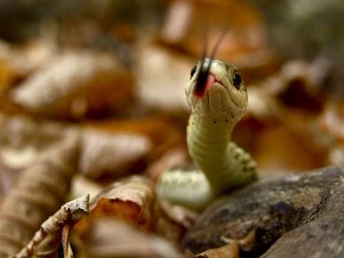
wildlife
Getting There
Mt Cabot is located in the northern exclave of the White Mountain National Forest, roughly bounded on the north and northeast by state Route 110, on the south by state route 2, and with the towns of Lancaster and Berlin lying off to the west and east, respectively. Within this rather large area, Mt Cabot is located about halfway along the north-south axis and not far from the west edge of the National Forest. There are no trailheads on the highways (except the Starr King trail in Jefferson, at the southwest tip of the WMNF area); dirt roads to the trails leave the highways as follows:A western trailhead (Mt Cabot trail) can be reached (via several dirt roads) from Rte 2 in Lancaster (look for signs for the village of Grange) or from the village of Jefferson near the intersection of rtes 2 and 116. IMPORTANT: MOST OF MT CABOT TRAIL IS CLOSED. See below.
The north trailhead of Unknown Pond Trail is reached via Mill Brook Rd from the village of Stark on rte 110.
The north trailhead of Kilkenny Ridge Trail is reached from South Pond Rd about three miles east of Stark.
The eastern trailheads (Bunnell Notch Trail and three others) are reached via York Pond Rd, which leaves rte 110 about six miles northwest of Berlin.
A gate crosses the road at the fish hatchery (about two miles short of the Bunnell Notch Trail trailhead) and is normally closed from 4 PM to 7:30 AM during the warm months; starting in October the gate is kept open for snowplows. The hatchery staff are sometimes flexible about gate closings if you ask very nicely: 603-449-3412.
Drive carefully - this is moose country!
Trails Summary
The summit is reached by the Kilkenny Ridge Trail,
KKR views
All of the trailheads are at around 1500 feet of elevation, so the most straightforward routes involve about 2500 feet of elevation gain.
In the past, the most convenient way to climb Mt Cabot was by the Mt Cabot Trail, which provided an easy and direct route from the west-south-west. Unfortunately, the lower sections of this trail pass over private land, and due to a dispute with one of the landowners, this trail is CLOSED until further notice. To check its current status, contact the Androscoggin Ranger District at 1-603-466-2713, or check the message boards on Views from the Top.
The westernmost section of the Mt Cabot Trail can still be used to access the west end of the York Pond Trail, which allows a roundabout approach to Mt Cabot from Willard Notch, by hiking over Terrace Mountain (for something like 1000 feet more elevation gain) on the Kilkenny Ridge Trail. Ten miles from trailhead to summit.
The Bunnell Notch Trail provides a direct approach from the east, and seems to be the favorite route now that the Mt Cabot trail is closed. The trailhead is at the western end of York Pond Rd - see above for details about the gate on this road. A bit under five miles each way, not counting the section of closed road.
Bunnell Notch note: Vegematic points out that at the eastern junction of the Kilkenny Ridge and Bunnell Notch trails, the sign for "Kilkenny Ridge Tr - Mt Cabot" appears to point north, off the trail. Stay on the combined Bunnell Notch / Kilkenny Ridge trail for another 0.1 mile westward before turning north on the Kilkenny Ridge Trail at the next sign. (This should be obvious in summer, but may not be in winter.)

Unknown Pond
A highly-recommended loop variation on the eastern approach takes you around Unknown Pond by using the southern half of Unknown Pond Trail and a section of the Kilkenny Ridge trail. Aside from the fact that many people prefer a loop, this route takes in the classic reflecting-pool view of the Horn from Unknown Pond, and also climbs the Horn itself, which provides the best views in the Pilot-Pliny Range. About eleven and a half miles round trip, not counting the closed road. Maybe five hundred feet more elevation gain than the direct approach.
The northern approach is currently the shortest. This route involves more elevation changes than the Bunnell Notch route, but the views are worth it. From Mill Brook Rd, the Unknown Pond Trail takes you to Unknown Pond, whence Kilkenny Ridge Trail climbs The Horn and then follows the ridge over The Bulge to Mt Cabot. Five miles each way, roughly 3000 feet elevation gain. The trailhead is at the second bridge on Mill Brook Rd (about four miles from Route 110). Mill Brook Rd is easy to find in the village of Stark, next to the grange hall.
A long variation on a northern approach, well-suited to an overnight trip (camp at Unknown Pond or Rogers Ledge), follows the Kilkenny Ridge Trail all the way from South Pond Rd. A shade more than nine and a half miles one way, maybe 3200 feet elevation gain.
Red Tape
Usual WMNF restrictions on camping, fires, and so forth. Follow Leave No Trace principles and you'll be fine.I'm not sure about the trailheads at either end of the Kilkenny Ridge Trail, but the usual $3 daily parking fee is not collected at the trailheads nearest to the mountain.
Just for completeness, here's a link to the discount parking pass program.
When To Climb
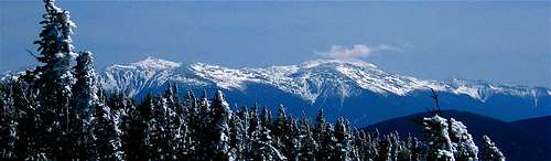
winter often means clear views
Check current road status. If you still have questions, contact the Androscoggin Ranger District at 1-603-466-2713, or check the message boards on Views from the Top.
Camping
Huts
cabot cabin
Cabot cabin is located at the south end of the peak. Room for 8, first-come-first-served, no fee. I'm not sure how late in the year it stays open. winter warning: vegematic says the wood stove has been removed - this means there is no heat source in the cabin!
Trailside Tentsites
You may camp at Unknown Pond, or about 1.5 miles further northeast at Rogers Ledge. Few details are available; if you have questions call the rangers at 1-603-466-2713.
Roadside Campsites
These are usually plentiful in New Hampshire, though this far north they may be a bit more sparse. Consult your favorite directory.
Backcountry Camping
Allowed, with the usual WMNF rules:
Unless otherwise posted, you may camp:
- Below treeline (where trees are 8 feet or taller).
- At least 200 feet from the trail and water sources.
- At least a quarter of a mile from any road or facility (ie, campsite, platform, shelter, hut).
Mountain Conditions
The trails to Mt Cabot are mostly sheltered. Conditions at the top won't be much different from those in the nearby towns, just a bit breezier.
External Links
- Hike the Whites
Maintained by Dave Metsky. Remarkably complete info about the mountains in the Whites, and tons of useful links.
Books & Maps
For the White Mountains generally, the "hiker's bible" is:AMC White Mountain Guide, $22.00. Includes trail descriptions and topographic maps (on paper).
You can also order tyvek versions of the maps separately for $24.00.
TigerMouth61 - Aug 25, 2016 3:02 pm - Hasn't voted
Mill Brook Rd is gated closed in winterUnder "When to Climb" it says: Mill Brook Rd is "not maintained in winter", which I suppose means you're free to take your chances or bring your own plow - there's no gate at the beginning of the road. But the Forest Service contradicts that on their "Unknown Pond North Trailhead" web page: Mill Brook Road is gated closed in the winter. source: http://www.fs.usda.gov/recarea/whitemountain/recreation/recarea/?recid=74531&actid=50
nartreb - Aug 26, 2016 9:30 am - Hasn't voted
Re: Mill Brook Rd is gated closed in winterThanks for the update. That "not maintained" was a direct quote from the old WMNF website - the gate must be new (since 2009).