

-
 22431 Hits
-
 83.22% Score
-
 17 Votes
|
|
Mountain/Rock |
|---|---|
|
|
45.14940°N / 109.8314°W |
|
|
Hiking, Mountaineering, Trad Climbing, Scrambling, Skiing |
|
|
Spring, Summer, Fall, Winter |
|
|
12337 ft / 3760 m |
|
|
Overview
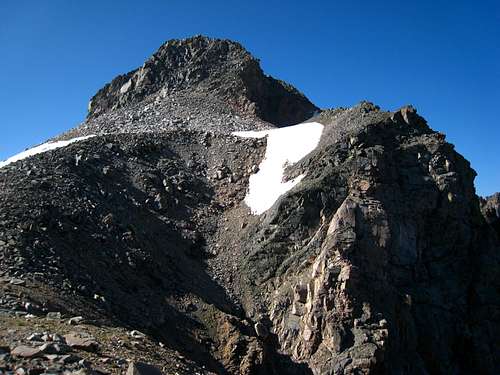
Mount Villard, named after a president of the Northern Pacific Railroad, is Montana's 13th highest ranked peak and one of Montana's 27 12,000 foot peaks with 300+ feet of prominence. Located a little over a mile Southwest of Granite peak it can be found on the "Granite Peak" USGS Quad map. Mount Villard actually has two summits, the main peak is the Eastern one with the western summit, also called "Hidden Peak" is about a quarter mile to the West. A drop of about 150 feet separates the two and both summits are nearly identical in elevation. While Granite Peak gets a lot of traffic, Villard is rarely visited. Also it's position between Granite and Glacier Peaks hides it but as a Montana 12er, it is a very worthy objective.
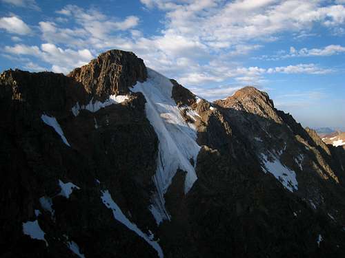
The most striking feature in the immediate area is the long, rugged ridge extending to the south from the summit. These are known as the Villard Spires and offer adventure climbing at its finest for those interested in some technical first ascents. Another striking feature on Mount Villard is the north face which drops very steeply into the extreme upper reaches of the West Rosebud drainage. This incredible face offers at least two technical routes with the potential for more.
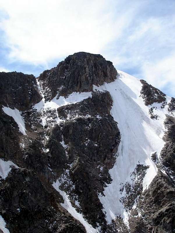 Close-up of the North Face | 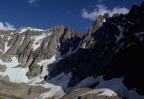 North Face of Villard |
Getting There
AERO LAKES TRAILHEAD
This trailhead is used to approach anything along the south side of Granite Peak and nearby peaks. This is the best start for anything on Mount Villard. From the small town of Cooke City on US Highway 212 (Beartooth Highway), drive east for 2 miles and turn north onto Lulu Pass Road. Go 2.5 miles (mostly gravel) to a large junction (Goose Lake junction) and locate a short road off to the right. Turn right (east) onto this road and continue for a rougher (but still passable for most cars) quarter mile to its end at a small mining cabin with mining relics scattered around. There is room for about 6-8 cars here to park.
 Sheep Mountain from the Lulu Pass Road | 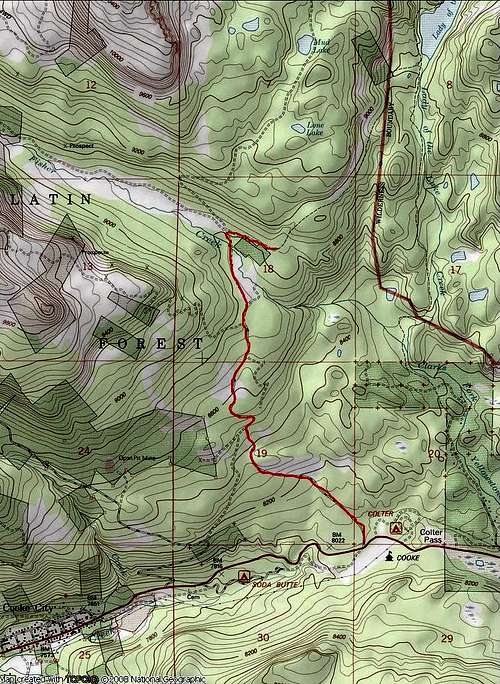 Trailhead Map |
Approaches
AERO LAKES APPROACHFrom the lower trailhead, there is a large cabin nearby just to the east. Walk around it on the left side (passing an old hot water heater) and cross a small stream on some boards or rocks. Emerge on the trail after a few feet of bushwhacking and walk northeast on the trail passing a large sign for Lady of the Lake. The first part of the trail heads up a short steep section and mellows to a nice undulating hike through sparse forests reaching the south end of Lady of the Lake at 8,750 feet after 1.5 miles. Follow the trail around the west side of this large lake (with great fishing and camping) and reach the junction with the trail coming down from the upper trailhead after another mile. A large cairn marks this junction. Continue straight and pass around a large meadow and cross a small creek which flows back down to Lady of the Lake. Don't follow this creek as it curves back to the south. Utilize rocks and logs to get across, then stay on the trail heading up through some trees and reach an obvious (but unsigned) trail junction 0.5 mile from the creek crossing. A few logs block a trail heading straight, however this trail is the route for the Sky Top Creek Approach described below. I will call this trail junction the Tri-Creek junction since it's where Zimmer Creek, Star Creek, and Sky Top Creek converge to form the Broadwater River. For the Aero Lakes route, you want to take the left trail. Your first views of Mount Zimmer and Iceberg Peak are found here to the north. A few minutes beyond the Tri-Creek junction, cross Star Creek a few feet before it dumps into Zimmer Creek and continue up the trail which follows the west side of Zimmer Creek for another mile. When the trail once again reaches the creek side, cross it on a couple large logs at 9,150 feet and locate the trail heading northeast towards Aero Lakes. This junction is unsigned so don't miss it and continue up Zimmer Creek. The trail quickly begins to climb steeply for 900 feet up what is known as heartbreak hill, reaching Lower Aero Lake after another 1.1 miles at 10,000 feet. The final quarter mile to the lower lake is hard to follow, just follow large talus through an obvious gap and descend 50 feet to the lake shore.
Here at the lower lake, the official trail ends (5.4 miles from the TH) but a boot path heads west around the lake, reaching its southwest corner after 0.3 miles which has a nice calm area making for great fishing. Continue along the northwest shore for another 0.9 miles and reach a small stream coming down from the northwest which drains a small lake above and to the north. Descend 50 feet to the creek, cross to its east side, and follow this drainage up to a very broad 10,160 foot saddle. Descend a short ways to the upper lake outlet stream and find a place to cross it. Wading may be required in early season. Reach the Upper lake at 10,170 feet and hike east around its south shore, then north around the east shore for 1.3 miles from the outlet. Stay close to the shore on the east side to avoid annoying talus traversing. Begin an ascending traverse and cross a small stream reaching a small tarn at 10,330 feet (200 feet above Upper Aero Lake). The camping at this tarn is fantastic and out of the bugs that flock the lake shore below. Views of Glacier, Villard, the Spires and the upper lake below are out of this world! This beautiful spot is 3.3 miles from where the official trail ends making the total distance 8.7 miles from the trailhead with only a 1,500 foot net elevation gain.
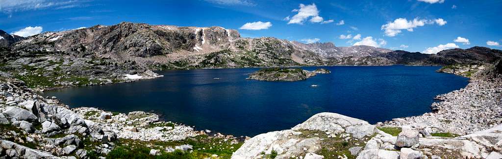
Lower Aero Lake Panorama from the end of the official trail
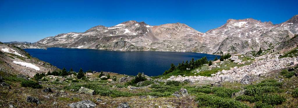
Upper Aero Lake Panorama from the Upper Aero camp spot
SKY TOP CREEK APPROACH
From the Tri-Creek junction (see above), instead of taking the left trail for the Aero Lakes approach, continue straight and follow the trail as it heads along the right (south) side of Star Creek for a few minutes. Locate a place to cross Star Creek on logs or rocks and pick up the trail on the north side. Continue to follow the north side of Star Creek downstream in an eastward direction and descend on the trail about 100 feet to Sky Top Creek. This entire Tri-Creek Junction is confusing since many social trails criss-cross the large meadow where these three creeks converge. Best to avoid trying to find the correct route through here at night. Parties have gone in circles here for hours in the past.
The trail reaches the north/west side of Sky Top Creek and continues near its shore for 0.75 mile to the stream draining Aero Lakes. Cross this barrage of streams and marshland on mainly well placed logs (or wade in early season) and locate the trail on the other side. Continue another 0.75 mile to a large flat meadow at 9,400 feet. The trail follows the left side of this half-mile long meadow. Just before the large cascade at the head of the meadow, the trail heads up to the left, over a small ridge and begins climbing steeply for another mile to Lone Elk Lake at 10,065 feet. Shortly before reaching the lake, the trail crosses a small stream draining Shelter Lake off to the north and passes over a small saddle to bypass the waterfall a few feet below the lake. The first real good views of the Villard Spires can fe found at Lone Elk Lake.
Hike around the left (west) side of the lake and cross the inlet stream above the small cascade. Continue around the right (east) side of Rough Lake which sits at 10,140 feet and hike up the right side of its inlet stream through a narrow gorge. Cross to the north side of this stream when possible (jump across a narrow section) and hike up the hill and reach the top of a broad ridge at 10,450 feet to the left (west) and roughly 100 feet above Lower Sky Top Lakes. Hike around the left side of the Lower Lakes and descend to the west shore of the two-part upper lake. Continue along the west shore of the upper lake (which is divided into two sections by a short stream) and set camp on a small flat patch of grass at the north end of Upper Sky Top Lake just below the 10,840 foot saddle between Point 11,379 and the Villard Spires. Camp is at an elevation of 10,480 feet. This approach is 9 miles each way from the trailhead with a net elevation gain of just over 1,600 feet.
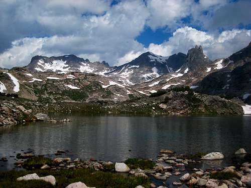
South side of Mount Villard at right-center from Rough Lake
For access to the north face of Mount Villard, continue up the valley below the east face of the Villard Spires and towards Granite Peak. Instead of bearing right towards the large moraine and the route for the SW Couloir of Granite Peak, begin ascending leftward in a NNW direction up a grassy rib which tops out at 10,850 feet in a tiny bowl above and west of the highest lake in the center of the large moraine south of Granite Peak. Continue west up moderate snow or talus to the broad 11,500 foot saddle between Mount Villard and a small unnamed point just to the north. The Northeast Ridge of Mount Villard begins from this saddle and it takes about 1 hour to reach the saddle from the Upper Sky Top Lake camp shown on the map. Fantastic views west of Wolf Mountain and Sawtooth Mountain are found here especially in the morning.
Cross over this saddle and descend west on loose scree and talus (or moderate snow) for 1,150 feet to a nice meadow at 10,350 feet on a flat bench directly across from the Beckey Couloir on the North Face of Glacier Peak. This spot, sometimes called the Glacier Peak Cirque, is at the highest upper reaches of the West Rosebud drainage and with the wild, rugged north faces towering above, it is one of the most incredible spots in the entire Beartooths!
 East Face of Mount Villard from the Upper Sky Top basin | 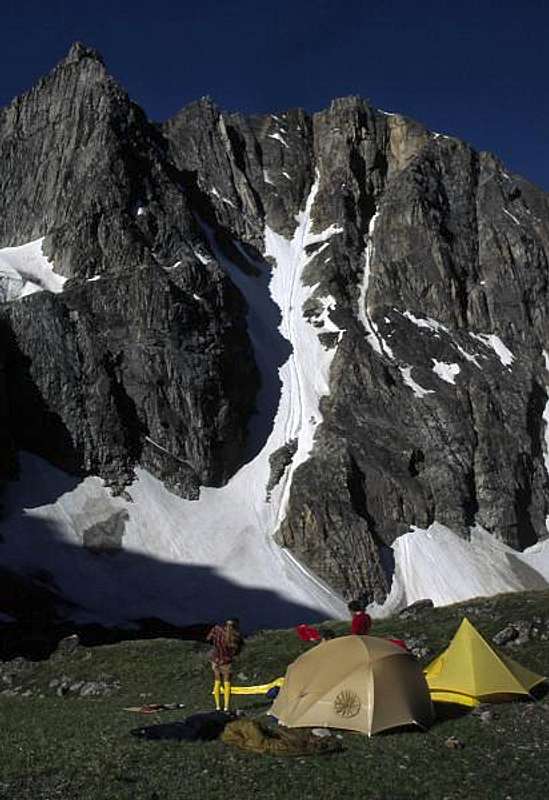 Camp below the NF of Villard | 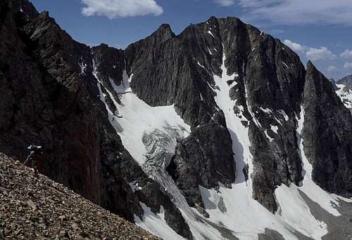 Descending into the Glacier Peak Cirque from the 11,500 foot saddle |
One could also approach to the Glacier Peak Cirque via the West Rosebud/Huckleberry Creek/Storm Lakes route however this has much more elevation gain due to the low West Rosebud Trailhead. The overall mileage is also longer and the difficulty greater due to the large amounts of talus in the Snowball Lakes area and the Storm Lakes basin.
Route Options
South Slopes - Class 2
This is the standard route on Mount Villard. Use the Aero Lake approach and get to the north side of Upper Aero Lake. Continue north either to the right or left of an unnamed 11,000 foot knob. Nice gullies are found on either side and both reach the beautiful tarn at 10,860 feet (which is snow covered until August). Continue NNE onto the orange colored scree slope leading directly to the 12,170 foot saddle between Villard and "Hidden Peak". This slope isn't much fun and is better climbed when covered with snow. It's steepness never exceeds 40 degrees so an ice axe and crampons are the only technical gear that may be required. After mid-August, the snow can be avoided if you prefer the one step up/one step down type hiking. From the saddle, it's an easy 5 minute stroll east to the summit from the saddle.
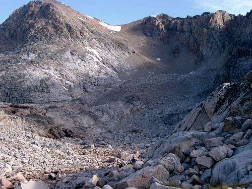
Route up the south slopes of Villard head up the obvious scree
Northeast Ridge - Class 4
See the Sky Top Creek approach description above and follow the route towards the Glacier Peak Cirque to the broad 11,500 foot saddle northeast of Mount Villard. From the saddle, turn left and begin on the easy ridge for 300 feet on large talus to where the ridge steepens at 11,800 feet. Scramble up a Class 3 gully to the right (west) side of the crest and regain it at 11,900 feet. Continue up the ridge and reach a small flat spot at 12,020 feet at which point drop a few feet to the right and begin a traverse around the right side of a small tower utilizing a good ledge. Locate a 10 foot slab and chimney allowing a third class route back to the crest. Scramble on the now very exposed ridge crest without gaining much elevation and descend 40 feet into a small 12,040 foot notch. Climb 30 feet up a Class 4 dihedral, traverse around a large boulder and descend a short ways to a second small notch. Scramble up now easier terrain on the crest for 40 feet (Class 3) to where the ridge flattens. From here, it's 200 more feet on the now broad crest over stable talus to the summit. Plan on at least 2, likely 3 hours round trip from the 11,500 foot saddle.
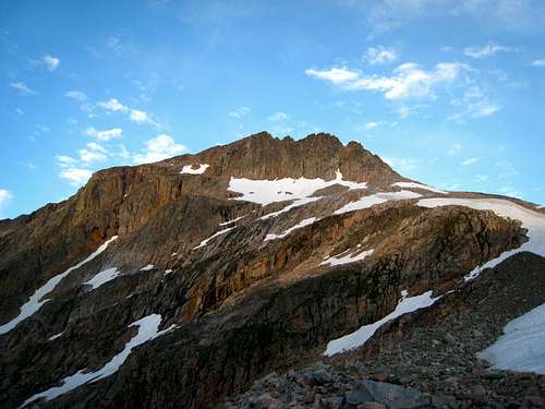
View west from the saddle at the base of the Northeast Ridge
 View from the saddle at the base of the NE Ridge | 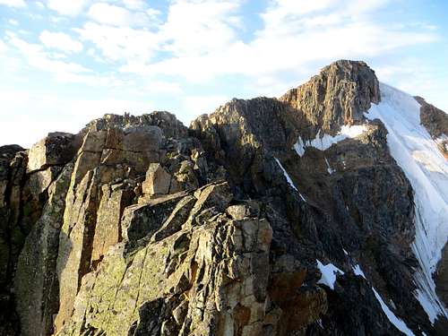 Scrambling the exposed ridge crest | 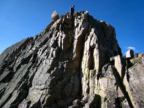 4th Class crux dihedral of the NE Ridge |
Villard to Glacier Traverse - Class 3
The traverse between Mount Villard and Glacier peak is mostly a Class 2 scramble. Be careful when reaching the saddle between Villard and "Hidden Peak" as a large cornice typically forms there. The traverse is about 1 mile between the peaks with the most sustained scrambling found descending the west side of "Hidden Peak" to the low saddle. Any difficult section can be traversed around on the south side of the ridge. The easiest way to nab both Villard and Glacier involves climbing the south slopes route of either peak, traversing the ridge to the second, then descending the south slopes of the other peak. The loop can be done in either direction with camp at the Upper Aero Camp or another camp spot at the outlet of Upper Aero Lake.
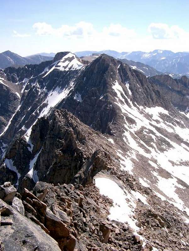
View of the traverse to Villard from Glacier Peak
North Face Technical Ascents - Northwest Buttress and North Couloir
In 1979, there was a route done by Peter Cole and company on a small buttress heading up the north face to the right (west) of the large snow couloir heading directly to the right of the summit. For convenience, since the party didn't appear to name the route, I will name it the Northwest Buttress. The route, which is shown in the middle photo below (with the yellow line), involved mostly 5.7-5.9 free climbing, a small section of aid climbing, and 40-45 degree snow above which led directly to the saddle between Mount Villard and its western sub-peak (Hidden Peak) at which point easier terrain was reached. This route in more recent years will likely have a large cornice at the top to be aware of, however bypassing it to either side shouldn't be too difficult.
The north snow couloir leading directly to the right side of the summit can also be ascended when in good conditions. Snow and or ice steepness tops out around 60 degrees. Later in the season though it melts out on the lower half exposing horrible rock. See the first photo below for a view of this couloir.
 Mount Villard North Face with the steep snow couloir in the center | 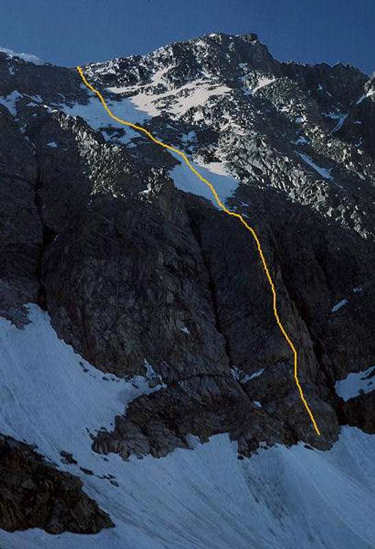 Line taken by justmeol to the Villard/Hidden Peak saddle | 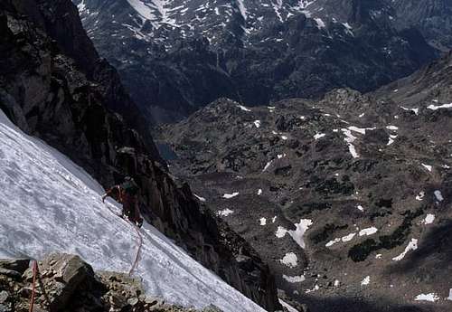 Climbing the upper snowfields above the NW Buttress |
Map
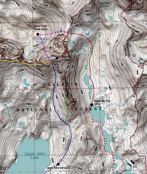
DOTTED RED: Sky Top Creek Approach - Class 1
SOLID RED: Mount Villard Northeast Ridge - Class 4
DOTTED BLUE: Aero Lakes Approach - Class 2
SOLID BLUE: Mount Villard South Slopes - Class 2
GREEN: Villard Spires HP West Ramp - Class 3
DOTTED ORANGE: Route Between Camps - Class 2
YELLOW: Mount Villard to Glacier Peak Traverse - Class 3
PURPLE: Mount Villard Northwest Buttress - Class 5.9, Some Aid & Mod Snow
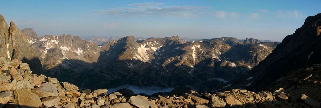
Summit Views
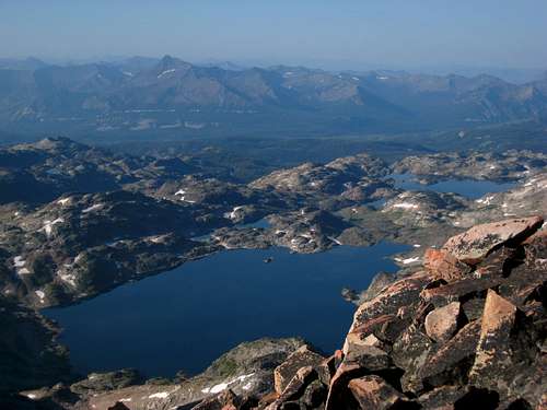 Aero Lakes from Villard | 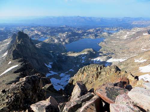 Aero Lakes from Mt. Villard's summit |
When To Climb
Summer climbing season is short in Montana. Late July through early September are the months that are most snow-free. However, expect some snow on the mountain any time of the year. Expect any type of weather any time of the year. Violent thunderstorms are a common daily occurance. Get an early start to avoid afternoon thunderstorms. Storms develop very fast and tend to come from the south or west.Camping/Red Tape
You can camp anywhere, but the best places are labelled on the map above. The Upper Aero Camp is about 150 feet above Upper Aero Lake just east of its easternmost point. There is a small pond here offering a water source and nice grass making this one of the best camp spots in the whole region. The other nice spot is at the north end of Upper Sky Top Lake where a small meadow next to the inlet stream offers nice camping. The route between the two spots connects the Aero Lakes and Sky Top Creek approaches shown in orange above, takes about 45 minutes to do and traverses over the saddle between Point 11,379 and the Villard Spires.
Mount Villard is located in the Absaroka-Beartooth Wilderness, Custer National Forest, Beartooth Ranger District. No fees are required to climb, hike, or camp. You must have a permit to cut live trees for firewood. No mechanized vehicles allowed in the wilderness area.
Beartooth Ranger District
6811 U.S. 212, Red Lodge, Mt 59068
(406) 446-2103
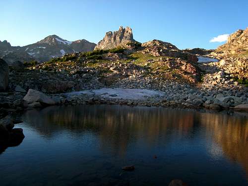
Small pond at the Upper Aero Camp
External Links
Photos of the 1979 ascent of the Northwest Buttress on Mount Villard - Click on the Alpine tab, then Montana, then the third gallery to view the photos.
Trip Report of Sarah and I on the NE Ridge and the Granite Peaks traverse