|
|
Mountain/Rock |
|---|---|
|
|
48.41630°N / 121.067°W |
|
|
8325 ft / 2537 m |
|
|
Overview
Formidable Mt. Formidable. Seems like an apt name for this mountain. I only wish I had not procrastinated so I could have put it up directly after Dow's Mt. Indefatigable page. Maybe if I hurry now I can make up for it by making Mt. Formidable mountain number 5555* on summitpost. Either way I'm sure I'll be making Bob Bolton happy as he now has a place to submit his wonderful photos of the mountain.
Mt. Formidable is the highest summit between Sahale Peak and Dome Peak in the North Cascades and is a member of the Washington Top 100, ranking approximatly 95th. Sahale and Dome were put up on summitpost long ago. It took four-and-a-half years to fill in a peak between the two (I'm ignoring the fact that this mountain was submitted previously by a member who went kablooey on this site). Formidable and nearby Spider Mountain rise up to form a long wall. A fortuitous col between them allows for easy transit for those trekkers doing the famous Ptarmigan Traverse.
The northeast side of the mountain is guarded by two glaciers (the Formidable and the Middle Cascade) an expansive face that looks diabolic (but has been climbed). The North Ridge has also been climbed (even in winter by Lowell and Gordy Skoog). The Northwest Face would seem to provide routes to the top but getting to the face (by way of Cleve Creek) would be problematic, although the creek bed appears to be a usable conduit through the brush. The South Face is not as spectacular as the north side of the mountain but still offers enough visual appeal--especially from a distance.
Rock is a "green schist complex cut by soft diabasic dikes which have formed staircase gullies." (Beckey)
The first ascent was by Ptarmigan Club members Calder Bessler, Ralph Clough, Bill Cox, and Tom Myers on July 25, 1938 during the inaugural Ptarmigan Traverse. They called the peak "Daiber."
* Of course, it had to be that the new version of summitpost doesn't use the old mountain numbering system. Now Formidable is a rather bland No. 154648.
 |
 |
 |
 |
 |
Getting There
To get to the start point for the hike in (Cascade Pass Trail), drive to the town of Marblemount via Hwy-20 and refuel and/or pick-up any last-minute supplies at the convenience store. From the main corner in town, drive east on Cascade River Road for 22 miles to the trailhead (3,600 ft). The road is kept in good shape and you don't need any special clearance and wheel base.
Approach (Ptarmigan Traverse)
The approach is described well in Eric Sandbo's wonderful Ptarmigan Traverse page. But because I had my own approach description written before he created his page, I'll offer my own here too. My "approach" ends at the Spider-Formidable Col. After that point see the South Face page.
Hike the stupidly-inclined Cascade Pass Trail for 3.7 miles to the pass (5,560 ft). It should take you 75-100 minutes to get there. Chat briefly with the cute ranger there to greet you then carry on your way after explaining that you won't be camping inside North Cascades National Park so you don't need a permit. From the embedded stones at the pass landing look rightward (southward) for a path leading up the ridge. That's your path. It goes toward Cache Col. Prepare yourself for some sketchy traversing.
The path begins nicely as it initially ascends through huckleberry bushes with the occasional salmonberry. About two-thirds of the way to the Cache Glacier (still unseen around a corner) the path may cross an eroded gully with a steep unscarifiable side wall (hard dirt with imbedded rocks). A fall here would be disastrous so don't. It seems strange the trail goes high on this hard embankment instead of lower where the terrain is easier but, as Fay Pullen suggested to me, the sketchy trail probably appears there every year because that's where it crosses when still snowbound. At any rate, pass that sketchfest (50 feet of sphincter-clenching exercising) then pass another hard dirt slope before eventually coming to the high shoulder (~6,300 ft) where your first views of the glacier and Cache Col come.
There are two trails leading off the shoulder to the small basin below. Either one goes. Descend the 100 feet into the basin then bear toward the glacier on slabs and rubble. Fill up with water at outflows from the glacier as there won't be any more water (in late summer, at least) until you get to Kool Aid Lake or a possible stream a few hundred yards before it.
You can climb directly up the center of the glacier or stick to the right side. There is a rock slide across the glacier one has to cross (easy boulders). If later in the season keep keen for vertical shafts (not crevasses) in the ice where streaming water atop the glacier plunges away. I came upon several in a line right on the other side of the rock slide. They were bottomless shafts maybe three feet wide and at least 70 feet deep. Who knows where that water was ending up. The crevasses on the glacier are mostly benign cracks that can easily be stepped over. Take crampons and go right up the middle. The steepness of the glacier is pretty relaxed. Just below the col the glacier steepens a little. A moat forms. A deep hole on the right could form and will be downright scary to climb above (crampon sidehilling!). The left side offers an easier walk-off though then you'll have to "scrumble" your way up loose dirt to the top.
Follow the well-worn trail down the south side of Cache Col aiming for the pond that is known as Kool Aid Lake. If it is not socked in, you should be able to see the pond and the trail running a tangent to it. It is 700 feet below and one mile distant. There are a couple of steep descent sections where the trail is hard to follow (talus and heather terraces) but it should be obvious where to go.
Reach Kool Aid Lake and good camping about half-an-hour after leaving Cache Col. The lake is just a shallow pond so I recommend using a filter to take water out of it, else use year-round streams a few hundred yards away along the trail (especially to the south halfway to Red Ledge). If Spider is your only objective you could climb it from Kool Aid Lake and back and still get back to the car before dark. If you add Formidable to that you will need an extra five hours.
Keep following the trail south toward the rock wall coming off the west side of Arts Knoll. Red Ledge is next. It looks improbable from a distance but is easier than that, at least when not snowcovered. There is about 50 yards of steep dirt and/or snow to reach the ledge. Ice axe may be handy. From the top of the snowpatch clinging to the base of the rock wall or in the moat behind the patch, climb up and right on sandy Class 3 blocks to the ledge proper or go a little farther along the moat to a dirty Class 3 gully to reach the ledge point.
A fall here wouldn't feel very good. Plus, you could slide down the snowpatch. Now simply walk the 200-foot ledge (slight incline) to its end. There is one sketchy alcove above a chasm that is difficult in early season (a friend of mine slipped on steep snow and fell into the chasm; she lived) and another step-around past a minor shoulder-high bulge in the rock face.
Once past Red Ledge, keep following the trail for about a mile (some steep sidehilling on a narrow path). The low point of the traverse from Cache Col is about here (6,100 ft) to get past a minor buttress. Climb up again (scree and talus) to eventually reach the fringe of the Middle Cascade Glacier at about 6,500 ft.
Now there are many routes across the glacier. Use your best judgment. For sure the lower part should be avoided (crevasses and ice falls). We hugged the north side to about 6,900 ft (low angle ice in late season that requires crampons) then bore south avoiding crevasses as necessary.
The Spider-Formidable Col is at about 7,300 ft. There are actually two notches. The left (east) one is narrow. It provides access to the other side. The right (west) one is wide with a flat, though sharp, crest. There is space for two bivy sacks on the crest on the rightward col. If you have a tent, you could easily camp on snow in the hollow below the north side of the rightward col. Water here would have to be manufactured by melting snow.
Time = 7-9 hours from Cascade Pass Trailhead.
Gain = ~5,000 ft (including all ups and downs)
Distance = ~9 miles

 |
 |
Red Tape
There is no red tape other than the need for a Trail Park Pass at the Cascade Pass Trailhead and the need for a permit to camp at sites within North Cascades National Park (see Camping section below).
When To Climb
April to October. Access to trailheads in winter is your main problem. Other than that, it is conceivable you could climb Mt. Formidable and/or do the Ptarmigan Traverse year-round. To make use of the trails on the approach you'd probably have to wait until July. Otherwise, there will be a lot of plodding across snow with a heavy pack. The South Face of Formidable could be harder when snowcovered...or it could be easier.
Camping
Good camping is available at:
On the shoulder south of Cache Glacier (need a permit) -- 6,100 ft -- 45 minutes from Cascade Pass
At Kool Aid Lake (no permit required) -- 6,100 ft -- 3 hours from Cascade Pass
At Spider-Formidable Col (no permit required) -- 7,300 ft
On slabs or benches on south side of col (no permit required) -- allow 30 minutes from the col
At the 6,600-ft saddle 0.5 miles SSE of Formidable's summit.
 |
 |
 |
Views from the Mountain
 |
 |
 |
 |
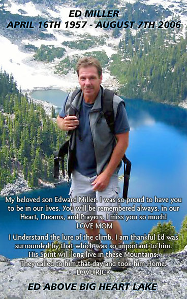
In Memoriam
Ed Miller, 1957 - 2006
On August 7, 2006 Mt. Formidable extinguished the light of a bright star in the Pacific Northwest when Ed Miller (rialtosol) fell to his death while crossing the rib that bisects the mountain's south basin. He will be missed. He has already been missed. His nonchalant spirit and nonpareil photography were an inspiration to many, including myself. I had in fact wished to speak with him about his digital camera choice because I thought I may be in the market for one (just as soon as my "archaic" celluloid one finally breaks for good).
I only met (and climbed with) Ed once on Whitehorse Mountain (trip report 1, trip report 2). He was a real stand up guy. The rappel from the summit was his first (presumably in the alpine environment). He and I were standing at the rap anchor and I announced it was his turn. He said it was his first rappel. This seemed surprising me since he had seemed so solid during the climb up as if he had been climbing for many years. So I allowed him to use my rappel glove so he wouldn't possibly burn his hand.
Some other information:
Tragedy on Formidable
Memorial Service for Ed
The Ed Miller Traveling Summit Register
Tribute Scramble for Edd (to Big Snow Mountain)