
-
 72218 Hits
-
 83.35% Score
-
 17 Votes
|
|
Mountain/Rock |
|---|---|
|
|
39.08170°N / 104.9263°W |
|
|
9063 ft / 2762 m |
|
|
Overview
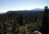
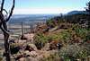
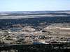
Mt. Herman lies along the Rampart Range of the Front Range between Denver and Colorado Springs. It is the pride of the town of Monument, Colorado to the east and looks over the Palmer Divide, a 7,000’ plus ridge extending well into the eastern plains which acts as a weather barrier between Denver and Colorado Springs. Summit views include Pikes Peak to the south and Longs Peak to the north (on a clear day) and both the Colorado Springs and Denver skylines.
The easiest route is a relatively steep Class 1 trail from a trailhead on Mt. Herman Road. This trail is about 2 miles one way with an elevation gain of about 1,000 feet. The peak sees a handful of people on nice weekend
 |
 |
Getting There
If traveling from the south on I-25 take exit 161. At the traffic signal turn left/west on State Highway 105 and cross to the west side of I-25. Just west of I-25, SH 105 turns to the north. At this point continue traveling west on 2nd Street.
If traveling from the north on I-25 take exit 161. At the traffic signal turn left/west on 2nd Street.
Travel a little over a half mile through the Town of Monument at which time you will cross railroad tracks and come to a T-intersection with Mitchell Avenue. Turn left/south on Mitchell Avenue. Travel a little over a half mile south on Mitchell Avenue at which time you will come to the signed Mt. Herman Road. Turn right/west on Mt. Herman Road. Just to the southeast of this intersection is Dirty Woman Creek Park – interesting name.
You will now be traveling west on Mt. Herman Road with Mt. Herman directly in front of you. Continue on Mt. Herman Road as it turns to a gravel surface and starts to traverse across the east face of the mountain from north to south. Although I did see some passenger cars beyond this point a high clearance vehicle would be the best vehicle from here on out. Follow the road around the south side of Mt. Herman to the southwest side of the mountain to a small parking area on the outside of a switchback. There is a Forest Service marker on the right side of this parking area labeling Trail 716. This is the trailhead for Mt. Herman. I didn't check the odometer but my topo software indicates that the trailhead is located just under 5 miles from the beginning of Mt. Herman Road.
Mt. Herman Road is an important access into Pike National Forest as it is the only good public access between Garden of the Gods (Rampart Range Road) in Colorado Springs and Sedalia.
 |
Red Tape
The entire trail is within the Pike National Forest. No permits are required.
When To Climb
The trail could be done year round except perhaps after a heavy snow. Parts of the trail hold snow well into spring so water proof boots may be more comfortable in snow and spring season. During winter the Mt. Herman Road may be closed resulting in a much longer approach.
Camping
This is a relatively flat area of to the left near the beginning of the trail. The route is located in Pike National Forest and heading further up and west on Mt. Herman Road leads further into the Forest and many camping opportunities. There is a campground in Monument along Mitchell Road that you drive by accessing the trailhead but it is primarily for RV’s and Campers.
Mountain Conditions
Check local weather here.
summit21 - Feb 13, 2019 4:05 pm - Hasn't voted
#716TH Distance and gainThe author says it is 2.2 miles one way. The distance one way is 1.1 miles with 900 feet of gain. RT distance is 2.2 miles.