
-
 28450 Hits
-
 90.97% Score
-
 34 Votes
|
|
Mountain/Rock |
|---|---|
|
|
42.29900°N / 123.8453°W |
|
|
Hiking |
|
|
Spring, Summer, Fall |
|
|
5098 ft / 1554 m |
|
|
 Topping the list at the summit of Pearsoll Peak
Overview

Pearsoll Peak is the king of the Kalmiopsis Wilderness area and as such warrants mention in an area that is largely unknown and ignored. The Kalmiopsis Wilderness area is one that is totally in Oregon and contains 179,755 acres. Many of you may recall the attention this area did manage to get when the fire known as the "Biscuit Fire" swept the area in 2002. The Biscuit fire was huge, encompassing almost all of the Kalmiopsis Wilderness area and totalling over 500, 000 acres in all. It was the biggest forest fire in the history of Oregon according to one source and impacted this area in a significant way. Due to the difficulty and remoteness of the area, not much could be done to fight the fire. I'll write more about this in a later section and provide some links that you might find interesting to check out.
Persoll Peak merits attention since it is one of Oregon's 73 Prominence Peaks, coming in at #28 on the list. SP member, Dennis Poulin happened to be the first to bag all 73 of these peaks and this was accomplished rather recently in late September of 2005. I was glad to witness that event which is what gave me acquaintance to this interesting area and this terrific viewpoint. On a clear day, the Pacific Ocean is visible to the west and we could see a bit of Mt. Shasta to the southeast. Mt. McLoughlin is visible to the east and other peaks such as Preston and Bear are visible to the south across the California border. There is of course, the whole of the wilderness area to be seen from this viewpoint and the effects of the fire are obvious. Lest it be assumed that this is a fair weather peak, nothing could be further from the truth. In the winter, this peak is lashed with winds that exceed 100 MPH and rime ice and snow can be found in abundance, rendering this area inacessible to all but the most hardy.
Atop Pearsoll Peak is the other attraction (besides being a prominence peak), the Pearsoll Lookout. Still maintained by a volunteer group and available to the public. See the section on the Lookout and its information below.
Getting There
From Grants pass take the Redwood highway (Hwy 199) to Selma. In the town of Selma turn right at the yellow blinking light and take the small one lane road (Illinois river road) about 11 miles along the Illinois River to FS road 087. The road from Selma is narrow in places and care must be taken to watch for oncoming vehicles. You'll pass Six mile campground and Store Gulch guard stations on the way in. One stretch of road is dirt at this time but it is short and occurs near the 6 mile area.FS road 087 which drops down a fairly steep dirt road to the Illinois River which is crossed by an interesting bridge that rattles a bit as you drive over it. The area known as the McCaleb ranch, is a boy scout camp that burned in the Biscuit Fire. Also nearby is a suspension foot bridge which you can take but my recommendation is going down and driving across the river. You can park your vehicle in the wide parking area for a good walk or if you have a high clearance 4WD vehicle, and like to punish it, you can continue through the gate at the far end of the parking area and head up a road that will take you close to the peak. Or lacking the conveyance recommended, you can walk up the road. See red tape below for date restrictions.
McCaleb Ranch route is probably the most common approach from June to late September. The road is closed from Oct. 1st through the first of June. See info posted at McCaleb Ranch route for the reason for the closure.
Onion Camp route: The alternative when the road is closed.
Red Tape
No permits are required at this time. Be aware that the the gate and the road behind it is closed from Oct. 1st to June 1st and access isn't permitted which makes access necessary via the Onion Camp route.For more information:
Illinois Valley Ranger District
26568 Redwood Hwy
Cave Junction, OR 97523
Voice: (541) 592-4000
Fax : (541) 592-4010
TTY: (541) 592-4011
Selma
When To Climb
Spring, summer and fall. Recognize the fact that temperatures in the summer can reach 100 degrees and water is hard to find so be prepared. High winds are sometimes encountered and the beginning of wintry weather would make this a difficult summit for most people.Camping
It is possible to camp at several places along the road in, with campgrounds along the river at Six Mile and Store Gulch. There are other spots along the river where camping is feasible and just after the FS road 087 drops down a bit, there is a side road going up to the left where you could car camp. I just slept in my vehicle near the gate in the McCaleb Ranch parking area. There is no campground located at Onion Camp although you could sleep in your vehicle at the TH if need be.Accomodations are available in Grants Pas Oregon or Medford. You can actually camp in the lookout if you make the right arrangements with the Illinois Valley Ranger station:
Mountain Conditions
Chetco Ranger District - Siskiyou National Forest539 Chetco Avenue
BROOKINGS, OR 97415
Office Hours: 8:00 to 4:30 Monday through Friday Closed: 12:30 to 1:30 Monday through Friday
Weather conditions: Selma is the closest town

Grants Pass

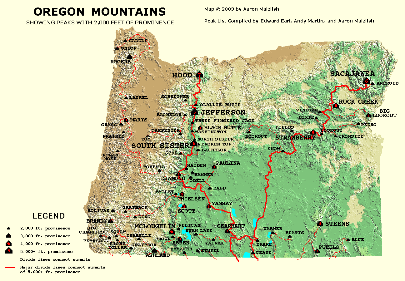
Oregon Prominence Peaks - the first completion
 73 down, none to go.
 Dennis, the first to complete Oregon's prominence peaks with over 2000 feet of prominence.
There are 73 peaks in the state of Oregon that qualify as Prominence Peaks (changed to 74 in 2009 with the addition of Echo Mountain). Just what the heck is a prominence peak? "Generally it requires that a peak has at least 2000 feet of elevation above the highest saddle that connects the peak from any higher peak." Confused? I was too for awhile. One neat thing about Prominence peaks is that they always have a tremendous view since everything around them is lower. Read the explanation at www.peaklist.com Well anyway, up to the 25th of September of this year, no person had ever been to the top of all 73. Enter Dennis Poulin from Medford Oregon. Dennis is an avid SP member and was also the first Oregonian to complete all of the Oregon county highpoints and is halfway through the 100 highest of Oregon. Last year he completed all of Nevada's county highpoints and has only 4 left to finish California off, no easy task. One dayhike that he did in California earlier this year was a 32 miler. The guy can flat out hike and climb. He does alot of his efforts solo but every once in a while I get to team up with him and it is a lot of fun to hike with this guy. (I should get paid big bucks for this tribute)
Consider the fact that Mt Hood, Mt. Jefferson, North Sister, Mt. Washington , Three Fingered Jack, Mt. Thielsen are among the 73.
These peaks aren't pushovers and can all be dangerous. North Sister is particularly nasty and one of the reasons a lot of others will never get all 73 done. Two Washingtonians are in pursuit of the 73, Ken Jones of Seattle has 61 and our own Bob Bolton has somewhere in the50's. I am lagging along at the low 40's but I've been to many of these prominence peaks and all
are little mini adventures since they take you to every nook and cranny of Oregon. What a great way to discover a state. Combine prominence peaks with county highpoints and you'll drive every road in the state before you're done. Best Oregon combo of prominence and county highpoint? Yes, it is Mt. Hood.
Note that 8 Dollar Mtn and Squaw Peak are nearby and are Oregon prominence peaks. As is often the case in Oregon with peaks that have clear views of their surroundings, these peaks have communication towers on them.
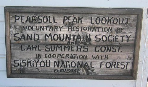
Pearsoll Peak Lookout
Pearsoll Peak Lookoutis one of eight remaining lookouts left in the Siskiyou National forest. The current lookout was built in 1954, replacing one that was of the cupola style built previously in 1933. Prior to the 1933 cabin, Pearsoll Peak was the site of a primitive fire lookout tent camp. In 1973 the lookout was closed and only occasionally used during times of high fire danger. By the late 1980's, lack of use almost led to the total elimination of the lookout but the people of the Illinois Ranger district, recognizing that they had something special in their midst, put together a united effort in 1991 and restored the lookout. The volunteers who maintain the lookout are referred to as the Sand Mountain Society and have kept it open free to the public to use since 1994. Reservations to use the lookout overnight are required. If you visit, please remember to close the door and put everything back as it was as you found it. This placeis indeed a treasure. One of the entries in the logbook detailed a three day stay by a family of four that had nothing but fog for their whole stay. They had a less than enjoyable time just trying to find things to do so perfect weather in this area of Oregon is not a slam dunk.
We had a chance to read much of the log and a most interesting entry was made by a couple from Illinois who flew to Medford for the express purpose of staying three nights in the lookout earlier in the month of September (2005) A hilarious read. To see this entry, click here.
Here's a neat story by a person who loves Pearsoll Peak Lookout
The sign attached to the outside of the building
The Biscuit Fire of 2002
2002 was a bad year for fires in the United States with over 7 million acres taking a hit. Almost 9 percent of that total occurred in southwest Oregon and was the biggest fire that Oregon had suffered in over 150 years. I've put up some links if you are interested in learning a little more about this fire and how it affected the area and the people.Link One A survivor's story
Link Two The fire as seen from space
Link Three Summary and map
Link Four Probably more info than you can wade through but yet....
Link Five U.S. Forest service report on the recovery of the area.
LInk Six Biscuit Fire Photo page (lots of pics)
LInk Seven More pics but from a small plane
and the last link, another survivor story. There are many more pages of info and pics on this fire but this should be enough to
saturate anyone who wanted to know more about this particular fire.
Redwic - Jul 2, 2012 10:11 am - Voted 8/10
Incident At McCaleb RanchLet this tale be a lesson to others. After summiting Mount Bolivar, Brandy Peak, and Grayback Mountain, I had enough daylight to drive to McCaleb Ranch. When I reached the lower parking lot (near the gate), an elderly man with white hair and long beard came out from the ranch above it and told me to leave. He said the parking lot was part of their private property and I had to park in the upper lot & use the footbridge (suspension bridge). He said it was OK for me to car-camp in that upper lot, too. Then his questions became much more pointed and specific, and he seemed like he was trying to dissuade me from doing my Pearsoll Peak trip. I knew that the upper lot would add hiking distance and elevation gain to an already long hike, but I drove to the upper lot without complaining and during the next hour I organized my gear for the next day's hike. One of the first things I noticed was a fresh/clean broken car window on the ground in the upper lot. A car soon arrived at the lower lot, and I could see & hear the elderly man calling down to the driver, asking if he had passed me and my car on the road. About an hour later, after dark (nearly 10:30 PM), I could see & hear the elderly man sending the young 20-something driver and another guy to drive to the upper lot to "check on" me. They quietly drove by with just their parking lights on, and I pretended to be asleep in my car. They parked immediately in front of the large trailhead sign, got out of the car, and just stared at me for a few minutes. By this time, I was already outside of my car and watching them, too. I said, "Oh! I thought I would be the only person up here tonight. I need to go get something" as I walked around them to the trail. The driver asked, "Where is the trailhead at?" I pointed to it, and I knew he intentionally had parked up against its entrance to monitor me. I walked a short distance, grabbed my bike (which I had temporarily stashed next to the trail to help keep it from being stolen), and quickly walked back. The two guys passed me and asked how to get to the footbridge. I kept walking and passed them as I replied, "Just follow this trail for a few switchbacks" as they slowly continued down the trail. I quickly got back to my car, stashed my bike in it, and then I heard the elderly man yelling out from the ranch to the two guys, about me. The last thing I heard him say was, "You know what to do!" and I jumped in my car and drove away. I do not know if they were just sent to the upper lot to harass or intimidate me (or worse), but some sort of shenanigans were going on and I was not staying around to find out. Fortunately, this was a blessing in disguise. I drove back to Highway 199 and then went to the Kalmiopsis Rim Trailhead near Onion Camp. After sleeping several hours, I began hiking at 3:40 AM. I reached the summit and lookout at 6:40 AM, stayed for 30 minutes, and then headed back. This is a great peak and a nice little lookout (which was being remodeled). I was hoping for outstanding views, but low clouds/fog hindered visibility. However, the entire Kalmiopsis Rim Trail was in excellent condition, and would be a great way to see more of the wilderness. Plus, it is less hiking distance (13.2 miles roundtrip) and elevation gain (2900' cumulative gain) than from McCaleb Ranch. I highly recommend the Kalmiopsis Rim Trail via Onion Camp. Do not even bother with the McCaleb Ranch approach, unless you want to take a chance of shenanigans being pulled on you or your vehicle.