
-
 16296 Hits
-
 89.39% Score
-
 29 Votes
|
|
Mountain/Rock |
|---|---|
|
|
46.31640°N / 11.83210°E |
|
|
9534 ft / 2906 m |
|
|
Overview
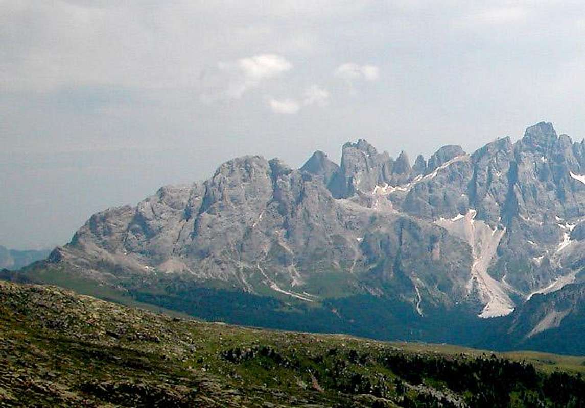
Monte Mulaz is located to the north of the multi-pinnacled nnorthern chain of the Pale di San Martino Group in the Dolomites and is thus a natural lookout peak to view the chain. With the Marmolada-, Bocche- and Lagorai Groups nearby the setting cannot be better. While the summit is not difficult to ascent it still is hard to get to - either the ascent routes are long or the gained altitude is huge. You'll probably have to take into account both. The best starting point for ascending Monte Mulaz is Passo Valles to its north. However you have to get to the far (southern) side of the mountain to get to its top.Monte Mulaz is a typical Dolomite summit. It is nearly 3000m tall, shows some very impressive northern and western faces but has an accessible south side from which you reach the top by a scramble. Consequently the views of the mountain differ very much, depending from which side you look. The most common view is from the north but here Monte Mulaz blends in with the slightly higher northern chain of the Pale. You could call it almost invisible.
Despite the long ascent routes Monte Mulaz is one of the most popular mountains of the Pale di San Martino Group. On a fine summer day you'll have to share the trails with lots of people. Many of them stop at Rifugio Volpi al Mulaz but still the summit can be quite crowded. Don't look for solitude there. When we climbed Monte Mulaz we were fogged out on the summit - during the descent it started to rain heavily. Still we met some ten people on the top. And we had started real early!.
As I didn't see anything on the summit my favourite recollection is the eastern route towards the summit. You pass the mountain on its eastern side and head for the Focobon Valley, cut deep into the rock between Mulaz and the Focobon Group. There you'll find the Campanili dei Lastei di Focobon, Cima Zopel, Cima di Campido and Cima Focobon towering directly above you with north faces that reach up to 600m in altitude. You crane your neck until it hurts! Surely awe inspiring!
Finally - after having been fogged out on the summit I tried to get as many shots of the mountain as possible. It eluded me - always clouds tried to hide it, no matter from where I looked.
:-(
 |  |  |  |  |
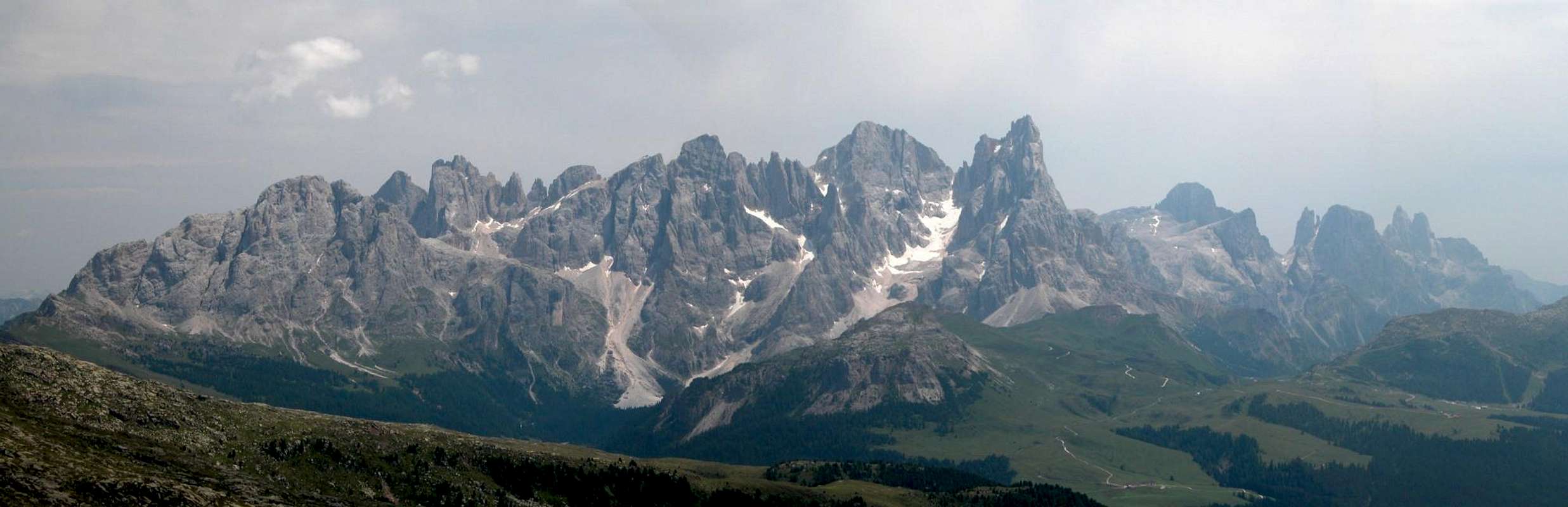
Panoramic View
M. MulazC. di CampidoC. FocobonCamp. FocobonLe ZircolleC. Val GrandeC. dei BureloniCamp. Val StrutC. VezzanaCimon della PalaPala di S. MartinoLa RosettaCamp. PradidaliC. BallSass Maor / C. della MadonnaC. della Stanga
 |  |
Getting There

There are several trailheads the best of which is at Passo Vallès. Malga Venegiota is another option and for the long haul you can start at Falcade and hike up the whole Focobon Valley (1800m elevation gain!). All three trailheads are connected with each other by SP81 which climbs across Passo Vallès.
Follow motorway A22 down to Cornedo (north of Bozen / Bolzano). There turn east on SS241 (Dolomite Highway) across Karerpass / Passo Carezza to Vigo di Fassa. At Vigo turn southward on SS48 which leads you to Predazzo. Turn onto SS50 east which you need to leave east of Lago di Paneveggio on SP81 north.
Take A22 north until the exit Ora / Auer. There turn east on SS48 direction Val di Fiemme which in the end will take you to Predazzo. Turn onto SS50 east and follow the instructions above.
Take SP203 north-west until you reach Cencenghie. There turn on SP346 east through Valle di Biois to Falcade. Shortly after Falcade Alto SP81 turns off left towards Passo Valles.
 |  |  |  |
Red Tape
  |
Like most of the Pale di San Martino and Cima Bocche Groups Monte Mulaz is part of the Parco Naturale Paneveggio / Pale di San Martino. There are no fees or limitations for hiking and climbing, however you need to adher to the "leave no trace" policy.
For more information you can look at the Park's official website.
 |  |  |  |
When To Climb

Monte Mulaz is a summer mountain. Ski tours usually only touch Passo Mulaz to the south of the mountain. I have no doubt however, that a ski ascent would be feasible.
The usual climbing season runs from late June through September.
Accommodation
For Hotels and appartments have a look at the websites of the towns and villages of the region:- San Martino di Castrozza - www.sanmartino.com
- Fiera di Primiero - www.dolomiti.it
- Falcade - Falcade
- Falcade - falcadedolomiti.it
If you are interested in the mountain huts and Refuges, just have a look at the Pale di San Martino Group Page
Weather Conditions
Weather and avalanche conditions in Trentino: www.meteotrentino.itWeather conditions in Belluno (east of Passo Vallès): www.meteoalpin.com. For the english text you have to scroll down the right frame.
Weather conditions Dolomites:www.dolomitimeteo.com
Maps & Books
Books:Climbing
Classic Dolomite Climbs: 102 High Quality Rock-Climbs Between the Uiaa Grades III and VII (also available on CD)
Anette Kohler, Norbert Memmel
Mountaineers Books
ISBN: 0 8988 6693 6
Hiking and Trekking
Dolomiten
P. Fleischmann
Kompass Verlag
ISBN: 3 8705 1409 4
Pala Gruppe
L Visentini
Ed. Athesia
ISBN: 8 8701 4612 X (german version)
Pale di San Martino
Luca Visentini (1990),
ed. Athesia, Bolzano
(with a handmade 1:25000 map)
ISBN 88-7014-598-0 (italian version)
Dolomiti - Scoperta e Conquista
Hermann Frass (1976)
Ed. Athesia, Bolzano/ Bozen
ISBN 88-7014-025-3 (italian version)
Maps
Pale di San Martino
Tabacco Map 022
Scale: 1:25000
Pale di San Martino
Kompass Map WK 622
ISBN: 3 8549 1548 9
Scale: 1:25000
Pale di San Martino
Kompass Map WK 76
ISBN: 3 8549 1086 X
Scale: 1:50000
San Martino di Castrozza e le zone adiacenti
Carta delle zone turistiche d'Italia
Touring Club Italiano
Scale 1:50000