Andrej Mašera in his recent book explains us that locals on the southern side of the mountain call it Crete Rosse (Friulano word that means "red rocky mountain"). Because of the nearby valley, called Aip, which means trough, and which really has such a shape, the today popular Italian name of an obviously newer origin is Creta di Aip. And the translation of that into German is so Trogkofel (Trog = aip = trough), which is nowadays used on the northern side and also broader. It is a historic fact that Slovenian people inhabitated the Gail/Zilja valley to Hermagor/Šmohor and even a bit higher, and that on the southern side they lived around Pontebba/Tablja, but the name which some Slovenian authors use for this mountain, Veliki Koritnik (velik=big, korito=trough) looks even more artificial.
Andrej Mašera writes also: It is very likely that shepherds and hunters were the first who reached the summit of Creta di Aip / Trogkofel, but the first recorded ascent was the one by J. Biebl & C. Prochaska, in 1886. From the southern side J. Frischauf was the one, who first climbed on top (in 1894).
Overview
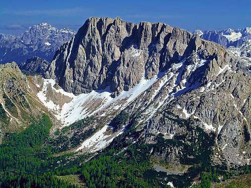
The main summit (right) and the north ridge
The view from the west
Going by the main Carnic Alps range, the mountains east of Ploeckenpass / Passo di Monte Croce Carnico get more and more humble. But a bit further towards the east, around the other mountain pass - Nassfeld / Passo Pramolo / Mokrine - they again look very attractive: rugged, with some high rocky walls and attractive pillars and towers rising out of them. Creta di Aip / Trogkofel is the highest and also has among all these mountains the most beautiful shape. Actually, only Polinik, far on the west, is higher in the whole Eastern part of Carnic Alps main range. The most characteristic view on Creta di Aip / Trogkofel is the one from Presseger See tourist area, where the mountain is giving a wild and attractive background to the lake scenery.
On the summit plateau
The view from the SE, from M. Cavallo / Rosskofel
From the east and from the west Creta di Aip / Trogkofel looks very similar. It appears as a high rocky fortress, standing quite apart from other mountains, with the highest peak on the northern part, and good 400 meters high, almost vertical north wall. Actually, towards the north a strong ridge is going, steep walls are falling towards the NNW, into the valley of Rattendorfer Alm (pasture), and towards the NNE, towards Rudnigalm (pasture). This northern ridge is separated from the main rock structure by Grosser Sattel, 1948 m, north of which some less important, but picturesque and wild summits are rising: Sattelkopf, 2040 m, Zuckerhuetl, 2060 m, Zweikofel, 2059 m and Hüttenkofel, 2013 m. Then the ridge lowers down on Troepolacher Alm (pasture), which can be also reached by a mountain road. The NNW wall is quite broad, made of four mighty pillars, the most eastern one reaching the very top of the mountain.
A very interesting feature of Creta di Aip / Trogkofel is its high plateau. Namely, from the summit peak towards the south a slightly inclined plateau is falling, but again ending in vertical walls. This broad, high plateau is an interesting example of alpine karst, there you can observe white rocks, carved by water, ravines and among rocks beautiful islands of vegetation. Towards the east, this plateau also ends with a rocky wall, actually, the triangular eastern wall of Creta di Aip / Trogkofel is quite high and attractive looking. Towards the west the high plateau is smoothly becoming a crest in which again a few nice towers are rising: Torre / Trogkofel Turm, 2186 m, Point 2016 m and finally the broader Zottach Kopf, 2046 m. And a final word about the southern walls - you'd expect that in the range of more than a kilometer such a mountain would have towards the south a decent passage. But there's none. The southern wall is not really high, it's only some 150 meters tall, but the easiest ascent over it still requires an easy climb, just degree UIAA I.
On the other side of the main ridge SW of the Trogkofel massif rises an unimportant elevation of Monte di Val Dolce / Maldatscher Berg, 1875 m. It can be reached by a trail, starting on the cart-road which serves the Val Dolce alpine pasture.
The lower parts of the mountain are similar towards the north - long valleys descending towards the main valley of river Gail/Zilja, with many mountain pastures and well touristically exploited. On the southern side, Valle di Aip is running paralelly with the main crest, representing actually more or less a high terrace of the long Val Pontebbana. Along the whole main crest the border between Italy and Austria runs. On Creta di Aip / Trogkofel it follows the northern border of the high plateau and so it goes also over the highest point. Crossing the border is nowadays a non-issue.
East of Creta di Aip / Trogkofel, towards the Nassfeld Pass / Passo di Pramollo, a big ski centre is operating. Chair lifts and ski lifts are reaching here the main crest of Carnic Alps, and also many side ridges. In the vicinity of Creta di Aip / Trogkofel, a cable car reaches the point 1981 m, just east of the mountain. The southern side of the mountain is much less touristically developed and in this respect more beautiful and unspoiled.
Geology
Regarding the geological perspective, as the whole Carnic Alps main crest, also the broader area of Creta di Aip / Trogkofel is quite diverse. The picture right shows Trogkofel lithology, on the legend, only some most important rocks are named.
The most interesting is the summit part, which is built of (early) Permian limestone, some 270 million years old. The layer is up to 450 m thick on the north, but only some 150 m thick on the south. These reddish rocks are a quite unique example of the last sedimentary rocks of Paleozoic era, and are even named by the mountain: "Trogkofel limestone". We mentioned already the summital plateau of Trogkofel. Ascending by it, we can observe an interesting contact area between the light Trogkofel limestone and some 10 millions of years younger, dark rocks of Tarvisian breccia (on the picture violet with red dots). Both structures are being strongly affected by erosion.
South of the summit part, as elsewhere in Caric Alps, Older Devonian rocks can be seen, and along the main ridge (on the NW and SE) some Low Permian slate formations, not forming higher rock crags.
Summit Panorama
The view towards Reisseck
From the summit towards the SW
Exceeding by altitude all nearby mountains, Creta di Aip / Trogkofel has a respectively broad panorama. The rugged mountains along the Carnic Alps main crest, towards the south Creta Grauzaria and Monte Sernio, in the distance other Carnic Alps and Julian Alps summits. Towards the SW Dolomites are clearly seen, towards the NW Hohe Tauern and towards the N and NE the mountains of Gailtal Alps.
Getting There
DragoA - Approaching Creta di Aip / Trogkofel from the east
To see a broader overview, visit the Carnic Alps Main Ridge (East) page and the Carnic Alps main page. The two main approaches to Creta di Aip / Trogkofel are from the north (Austria) and from the south (Italy). The valley of Gail/Zilja can be best reached from Villach, driving towards the west, or from the valley of Drau, over Kreuzbergsattel or Gailbergsattel. Once in Hermagor/Šmohor, you can choose among the following possible approaches to the mountain:
Nassfeld Pass / Passo di Pramollo. Drive by the main road on the saddle, 1530m, or on Sonnleitn, 1422m, where the trails start.
Rudnigalm, 1621m. Deter in Troepolach right and follow a good mountain road till the pasture with the hut (restaurant).
Rattendorfer Alm, 1556m. Deter from the main road in Gail/Zilja valley in Rattendorf and drive by the mountain road to the pasture.
Use cable chairs and ski lifts. Some cable chairs operate also in summer, for example to Madritschen, 1919m, where they take you and your bike too.
The southern approach starts in Pontebba, where you exit the Tarvisio - Udine highway. From there you again drive either on:
Nassfeld Pass / Passo di Pramollo. Drive by the main road on the saddle, 1530m, or on Sonnleitn (on the Austrian side), 1422m, where the trails start.
Passo del Cason di Lanza, 1552m. This saddle can be also reached from Paularo.
All other approaches are longer, assuming that you are doing the whole multiday trek along the Carnic Alps main crest.
Routes Overview
Creta di Aip / Trogkofel and its marked routes
East walls
Hikes and Protected Climbing Routes
Basically 4 ascents reach the summit:
Uiberlacher Weg. An easy ferrata (on the 6-point scale: B/C), coming up by the NE face (Austrian side), 2 h 15 min. Nice and panoramic ascent!
Ferrata Crete Rosse. A medium hard (on the 6-point scale: C) ferrata, coming up over the eastern part of the south wall, 2 h 30 min. Attractive exercise!
The SW ascent. The "normal" route, but on the part over the S wall (150m) not protected, easy climb. UIAA I, 2 h 30 min.
Below and by the W ridge. Marked, but not protected, UIAA I. In the upper part this route is called Alta Via C.A.I. Pontebba and is supposedly harder than other routes. The ascent time depends on the starting point (Rattendorfer Alm or Passo del Cason di Lanza).
Unprotected Climbs
Trogkofelturm, 2170 m
SW face ramp. II, 130 m.
West route. F and W. Wiegele, 1971. IV, III, 130 m.
Edges of the W face. F and W. Wiegele, 1971. V, A0, V-, IV, 130 m.
W-NW edge. F. Unterluggauer & Co., 1976. V, A1, 50 m.
N wall – The Pillar. F and W. Wiegele, 1971. IV, III+, III, 180 m.
SN-NE edge. E. Dabernig, F. Unterluggauer, F. Wiegele, 1976. IV, IV-, 170 m.
E wall. K. Wiggisser, H. Raditschnig, 1930. V, V-, 80 m.
Trogturm, 2250 m
N ravine. III, II, 300 m.
N wall. R. Kuchar, H. Raditschnig, 1949. IV+, IV, III, 350 m.
N pillar (two entry variants). R. Mazzilis, D. Mainardis, 1983. V, IV+, 300 m.
Trogkofel, 2279 m, South face
E part of the S wall. III, II, 180 m.
Direct slabs over the S wall. L. Pastore, L. Piemontese, L. De Caneva, 1980. V+, IV. 150 m.
S wall, Left chimney with slabs. IV+, IV-, 150 m.
Right slabs over the S wall. S. Szöke, G. Egger, 1986. IV, III+, 125m.
S wall, Right chimney with slabs. B. Contin, L. Ceccon, V. Di Marvo, 1981. III+, III, II, 150 m.
S wall, Contin-Donadelli. B. Contin, G. Donadelli, 1981. III+, III, II, 150 m.
S wall, Dollinger. H. Dollinger, T. and G. Dirschl, S. Szöke, 1987. IV, III+, 140 m.
S edge. H. Peterka, 1930. V, IV+, 160 m.
S wall, right part. S. Szöke, W. Dauschan, 1987. V+, IV+, 120 m. Direct variant is VII-.
Trogkofel, 2279 m, East wall
Direct SE pillar. P. Holl, H. Witt, 1980. IV', A2, A1, 120 m.
SE pillar. M. Benedikt, J. Uiberlacher, 1929. IV, III+, 200 m. Crux can be detoured (III+).
E wall slabs. M. Benedikt, J. Uiberlacher, 1929. III, II, 180 m.
E wall, Slanted chimney. E. Spieß, W. Lackner, A. Marka, 1950. IV, III.
E wall, Left chimney. P. Holl, H. Gallhuber, 1976. V, A0, 180 m.
E wall, Right chimney. IV, III+, 130 m. Marked yellow – for abseil.
E wall edges. P. Holl, H. Bieber, 1981. IV+, IV, 200 m.
E wall ravine. P. Holl, 1987. IV-, III, 200 m.
E wall – Pillar. H. Peterka, 1930 (in descent). III+, III, 200 m.
Trogkofel, 2279 m, North wall
NE edge. L. and M. Patera, Platzer, 1913. III+/II to III, 330 m. The most beautiful route of this difficulty in the carnic Alps Main Crest. Description in German with a topo.
N wall. J. Kollnitz, H. Raditschnig, K. Wiggisser, 1927. IV, III, 350 m. Direct exit (A. Ceccon, E. Lomasti, 1978), V+, IV, 200 m.
NW wall. K. Wiggisser, H. Raditschnig, K. Kuchar, J. Kollnitz, 1929. IV+, IV, 600 m. Variant (H. Leipold, H. Raditschnig, 1931), III.
NW wall – Direct route. H. Leipold, H. Raditschnig, 1943. V, IV, 400 m.
NW wall of the W foresummit. H. Raditschnik, K. Poljeka, 1948. IV+, IV, 380 m.
Sattelkopf, S summit, 2040 m, N summit, 2034 m, Zuckerhütl, 2059 m, Zweikofel, 2013 m.
S approach. II, exposed, 40 m.
S summit - N summit ridge. III, II, 150 m.
N approach. K. Wiggisser, H. Raditschnig, 1929. III+, III, 200 m.
Zuckerhütl, S wall. K. Wiggisser, H. Raditschnig, 1929. V, IV, 150 m.
Zuckerhütl, S wall – Direct route. S. Szöke, W. Dauschan, 1987. VI+, V+, 110 m.
Zuckerhütl, S wall. L. Tillian & Co. IV, III, 120 M.
All ascents can be easilly done in one day, so no real need to sleep on the mountain. On the neighbouring alpine pastures there are huts, where you can also sleep. On Passo del Cason di Lanza there's "agriturismo", and similar huts are also on Rudnig Alm, Troepolacher Alm and Rattendorfer Alm. Around Nassfeld Pass / Passo di Pramollo there are many hotels, some of them operating also in summer. At the end of Aip valley, SE of Creta di Aip / Trogkofel, there's Lomasti bivouac, 1900m. It has 12 places and can be an excellent base for hikes and climbs in this area.
When To Climb?
Andrej Mašera - Creta di Aip / Trogkofel from the SW
To ascend Creta di Aip / Trogkofel it is best to choose dry seasons. The best months should be July-October. In spring the southern approaches are soon free of snow. As a ski tour Creta di Aip / Trogkofel can not be done all the time from the summit. The upper plateau should be great, then over the S wall you'd need to climb down and then from the Madritschen crest down on the Austrian side there's a usual ski resort anyway. Skiing on Passo del Cason di Lanza is probably over a too flat terrain or by the road. For weather conditions, see the main Carnic Alps page!
Books
Guidebook in Italian: R. Gaberscik: Guida escursionistica alle Alpi Carniche. STUDIO64srl Edizioni. 7th edition, 2010. (An unsurpassable guidebook!)
Guidebook in German: P. Holl: Karnischer Hauptkamm. Alpenvereinsführer. Rother Verlag. ISBN: 3-7633-1254-4. An excellent overall Climbing Guide through the Carnic Alps Main Ridge.
Guidebook and photomonography (in Slovenian): V. Pogačnik: Kar na Karnijce. Založba Narava, 2011.
A Final Remark
The originator of this page was DragoA. As he left the page long time with only a minimum of information and didn't respond to collaboration appeal, the ownership of the page was transferred. However, he is all the time welcomed to build the page. The two other members who know the area well, have editing rights.
Your Help Needed
I'd appreciate if you have any information of the following:
Any information of other climbs over the NNW wall?
Route description: West ridge?
Route description: Nordostkante?
More information about the ridge north of Grosser Sattel?
Children refers to the set of objects that logically fall under a given object. For example, the
Aconcagua mountain page is a child of the 'Aconcagua Group' and the 'Seven Summits.' The
Aconcagua mountain itself has many routes, photos, and trip reports as children.
Parents refers to a larger category under which an object falls. For example, theAconcagua mountain page has the 'Aconcagua Group' and the 'Seven Summits' asparents and is a parent itself to many routes, photos, and Trip Reports.

 17461 Hits
 85.36% Score
 20 Votes
 The main summit (right) and the north ridge
 The view from the west
 On the summit plateau
 The view from the SE, from M. Cavallo / Rosskofel
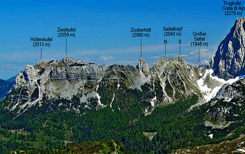
 From the west (Pian di Lanza)
 ganesh70 - From the east
 Herb - From the east in winter
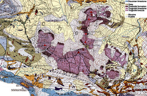
 The view towards Reisseck
 From the summit towards the SW
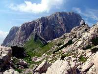 DragoA - Approaching Creta di Aip / Trogkofel from the east
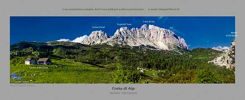 ClaudioNC - In Val Dolce valley
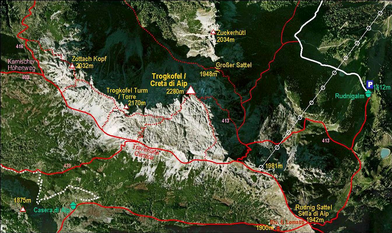 Creta di Aip / Trogkofel and its marked routes
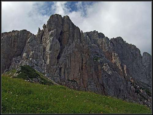 East walls
 Passo del Cason di Lanza
 dante - Lomasti bivouac
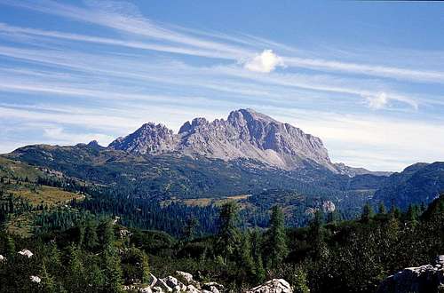 Andrej Mašera - Creta di Aip / Trogkofel from the SW
