|
|
Mountain/Rock |
|---|---|
|
|
38.43670°N / 119.3052°W |
|
|
11673 ft / 3558 m |
|
|
Overview
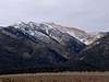
Mt. Patterson and the Sweetwater Range
Mt. Patterson is the high point of the Sweetwater Range, a somewhat overlooked but quite scenic and interesting neighbor of the larger and more heavily visited Sierra Nevada Range. Situated east of the Sierra Nevada and north of Bridgeport in the western edge of the Great Basin, the Sweetwater Range divides the West and East forks of the Walker River and straddles the California-Nevada border.
Geologically, colorful volcanic rocks possessing purple, red, white, green and yellow hues, many forming interesting and beautiful crystals, cover much of the Sweetwaters, including Mt. Patterson. Granite is also present in some areas. Although it is a comparatively arid range, the Sweetwater Range was the site of glaciation during the ice ages, signs of which can still be seen today in a few cirques and moraines. Generally however, compared with the Sierra, the slopes of the Sweetwaters are more rounded.
The Sweetwaters also contain vegetation common in both the Sierra and Great Basin. The Jeffrey Pine forests that cover much of the Sierra continue up the Sweetwater’s western slopes. Towards the east, the Jeffrey Pines, although not disappearing entirely, give way to singleleaf pinyons, mountain mahogany, and Utah juniper which are common plants of the desert ranges of the vast Great Basin, which stretches many hundreds of miles through Nevada and into Utah. Towards the top are common subalpine trees, including whitebark and lodgepole pines. Some reports indicate that ancient bristlecone pines are present in a few areas below timberline. Above 11,000 ft. lies the alpine zone.
Besides the interesting and varied ecosystems, the range contains a rich mining history. Abandoned mines and mining settlements from as far back as the 1860s are strewn about the east side of the range, including Boulder Flat, Clinton, and Belfort. A 4wd vehicle is required to visit these treasures. In addition, basque sheepherders have been grazing sheep in this area for over a hundred years and have left blazes on area trees for decades.
Because Mt. Patterson is a somewhat isolated high point it provides fantastic views. To the southeast are the White Mountains, where Boundary Peak, Montgomery Peak, and White Mountain are visible. Closer to the south is the Sawtooth Range of the Sierra Nevada. To the east are Mt. Grant. and the Great Basin Desert. Most impressive, however, are the peaks near Sonora Pass on Highway 108.
 |
Getting There and Climbing It
Getting to the top can either take a few hours or a half-day, depending on whether you have a 4wd or 2wd vehicle. Both variations follow the same route and are class 1, the difference being that climbers with 4wd vehicles may drive farther instead of hiking. If you have taken a 2wd vehicle to get to Mt. Patterson, please describe your experiences by adding information to this section, since I am only guessing about whether a 2wd vehicle could be used.
The Approach
From Bridgeport, drive 15 miles north on Highway 395. Turn right onto Road 31 and travel about 4.4 miles until reaching Road 67. Turn right onto Road 67. A few stream crossings are required. The streams have solid bottoms and are probably passable with a high clearance 2wd vehicle during the summer or early fall when water levels are low. Continue on Road 67 for 6.2 miles to Lobdell Lake, which is actually a reservoir. About a tenth of a mile before reaching the lake and shortly after one of the stream crossings, part of the road is washed out (as of November 2005). Persons with 2wd vehicles may wish to park before this point although it might still be passable; persons with 4wd vehicles may proceed. Regardless, persons with 2wd vehicles will have to park at Lobdell Lake, which is a short distance away, since the rest of the road up to Mt. Patterson gets pretty rough and requires using a 4wd vehicle.
The Longer Way to the Top: for climbers with low clearance 2wd vehicles
At Lobdell Lake, hike around the east side of the lake on Road 115, which eventually parallels Desert Creek, for 1.6 miles, until reaching a junction with Road 116. This part of the hike is flat. Continue on Road 115 by crossing Desert Creek on the right and climb up the road for another 3.7 miles until reaching the summit.
Oldadit had some success with his 2wd vehicle:
"I got my 1993 Honda Accord in to Lobdell Lake, and expect an experienced sedan driver could do the same. Snow banks made things tricky in a couple spots, but these will be gone soon." He also adds that the "west side" is better, the east side road ends at a old cabin."
10.5 miles round trip; 2600 ft. elevation gain.
The Shorter Way to the Top: for climbers with 4wd vehicles
Instead of walking, drive around the east side of Lake Lobdell on Road 115, which eventually parallels Desert Creek, for 1.6 miles until reaching a junction with Road 116. Continue on Road 115 by crossing Desert Creek on the right and drive along the road for another 1.2 miles. Most people will probably park before crossing the creek, although some 4wd vehicles and motorcycles climb to the summit. Unfortunately, a few thoughtless individuals have taken their motorcycles off the road and have driven over fragile alpine tundra, creating new tracks.
5 miles round trip; 1700 ft. elevation gain.
Climbing Wheeler Peak
It is possible to combine a climb of Mt. Patterson and Wheeler Peak, the Sweetwater Range’s second highest summit (elevation 11,663 ft.) by continuing south along the ridge following a 4wd road for about 2.25 miles. It looks easy, but I have not actually done this route so I am actually guessing about the difficulty.
A Possible Alternate Route
I have not tried this route, but it looks very doable as a short class 1 or class 2 hike via Wheeler Peak from the mining settlement of Boulder Flat. A 4wd vehicle is required to get to Boulder Flat. From Bridgeport, take Highway 182 north, which turns into Highway 338 after crossing the Nevada border, then travel for another 6 miles until reaching Sweetwater Ranch and Road 191 on the left. Take Road 191 for 1 mile. At the gate, turn left onto Road 198 and travel approximately 7 miles, climbing into the Sweetwaters, until reaching Boulder Flat, which has a couple of old mining cabins. From Boulder Flat, climb Wheeler Peak, the second highest peak in the Sweetwater Range. There is an old road that goes up much of the way. From there, hike north along the ridge until you reach Mt. Patterson.
 |
 |
 |
 |
Red Tape
The Sweetwaters are in Toiyabe National Forest. No permits are required, except for campfires, which may be subject to seasonal restrictions.
When To Climb
Ski tours are possible, although the climbing is easiest from July-October, give or take a month or two. Be sure the roads have had time to dry out.
Camping
Along Roads 31, 67 and 115 are numerous fine, free campsites, some with outstanding views of the Eastern Sierra.
Mountain Conditions
Contact Toiyabe National forest in Bridgeport at (760) 932-7070 or by clicking the link here for information on road, snow and weather conditions. Current weather conditions for nearby Bridgeport are below.
There is also a webcam of nearby Mono Lake, which should give you some idea of current conditions.
External Links
- Ghost towns
This link provides some information and photos of area ghost towns and mining camps, including Boulder Flat, Belfort and Clinton. The music on the home page is kind of annoying, but the site is worth a visit.
keema - Aug 17, 2006 4:13 am - Voted 10/10
Some more info.When approaching the turnoff from U.S. 395, the sign will say Bircham Flat Road. The sign for road 41 will then be seen once you turn off. When crossing Desert Creek on foot along road 115, be prepared to get wet up to your shins, or you can find a nice place to hop across about 30 yards upstream
gimpilator - Mar 30, 2015 2:21 pm - Hasn't voted
Boulder Flat approachThe road to Boulder flat is extremely rough and only suitable for trucks or jeeps. If any other sort of vehicle, I strongly suggest parking in the small plateau at 8500 feet, as described on the Wheeler Peak page. Even getting there might be a challenge depending on your vehicle.
Mtn Mike - Jul 7, 2021 7:56 pm - Hasn't voted
Lobdell Lake approach vehicle limitations.Firstly, this is a spectacular drive / hike and absolutely worth doing. Some notes with regard to the road conditions (this was in early July, so expect snow and or more water earlier in the season): Driving to Lobdell lake is rough in a few spots but easily passable with most 4 wheel drives with decent clearance. From here, more clearance is advised, and a short wheel based vehicle (jeep or side by side) is necessary to navigate the hairpins. Also, high center of gravity vehicles cannot manage the tilted road sections. From Lobdell, follow the road around the west side of the lake until you reach the outlet and dam on the south east side. There are some deeper water crossings and low clearance vehicles could take in some water. From here, take the road that follows the west bank of the creek southward until there is a creek crossing and shortly you will find a sign for Mt. Patterson. Do not go further unless you have a vehicle as described above. It's only about 3 to 3/12 miles from here to the summit so the hike is easy. My Wrangler easily made it to the summit and also across to Wheeler Peak along the summit ridge, with moderate care on hairpins and tilted sections.