
-
 13479 Hits
-
 94.63% Score
-
 48 Votes
|
|
Mountain/Rock |
|---|---|
|
|
46.44260°N / 11.78390°E |
|
|
8907 ft / 2715 m |
|
|
Overview
Geographical Classification : Eastern Alps > Dolomites > Marmolada Group > Colàc
Colàc - also Collàc - is the highest summit of the Colàc-Buffaure Subgroup within the Marmolada Group. It is a mountain of many faces - broad and massive when seen from the eastern and western sides it looks like a high and narrow tower from the north while from the south it appears to be a medium sized rock popping up out of the surrounding meadows. Forca Neigra to the south of Colàc is just 200m lower than the summit and quite naturally it is here where the normal route starts.
Though located in a perfect lookout position Colàc didn't see too many visitors before 1980. In that year a ferrata was established on the mountain's north face. The Via Ferrata dei Finanzieri is one of the more difficult ferrate in the Dolomites. It traverses the steep northern base of Colàc which is notorious for rockfall induced by other parties higher up on the face. Due to its steepness the ascent of Colàc can be done in less than 2 1/2 hours.
This, of course, is due to the fact that there is a cable-car leading up from Penia to the Ciampac meadows directly at the base of the mountain. A second stage can take you to Sella Brunec while another cable-car heads for the Buffaure summit. All three are within a mere hour's hike apart from each other. Loneliness is something you will certainly not encounter in the vicinity of the mountain. Still - thanks to the difficult routes - the summit is far less crowded.
As said above, Colàc is a grade A outlook peak. The setting is perfect to the west of the Dolomite's highest summit Marmolada with all the Groups of the western Dolomites all around. Though not taken from the top (rather from the base near Forca Neigra) this panorama gives a good indication of what you can expect.
This is the last of my 2005 Dolomite Submissions dating back to the July vacation. It took me so long to submit because I didn't climb the mountain myself and my efforts to convince one of the SP-members who climbed it for a joint effort were not very successful, Finally member Wokka agreed to share pictures and route description for the Via Ferrata dei Finanzieri. Those of you who speak German can visit Wolfgang's homepage for more information on other Ferrate of the Dolomites.
 |  |  |  |  |
Panoramic View
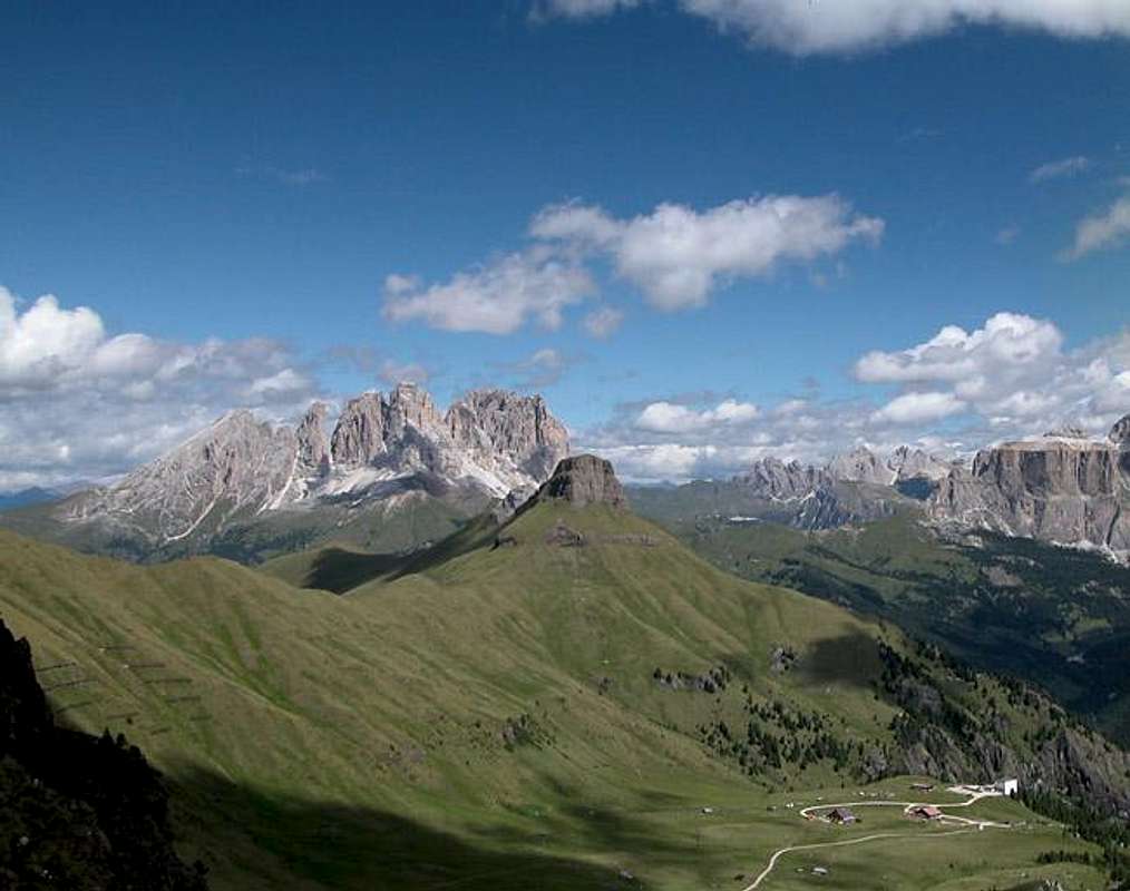 |  |
Colàc (far right) in front of the Sella-, Geisler/Odle and Saslonch/Langkofel/Sassolungo Groups.
The Setting

Colàc behind Torre Dantone as seen from Forca Neigra
In order to prove my statement that Colàc is situated in a perfect lookout location let me offer you some shots taken from or near its base. I hope they are convincing...
 |  |  |  |  |
Getting There

Hand drawn map of the Colàc - Buffaure Group (never mind the wrong Colàc altitude and different spelling.
As said in the overview section there are two cable-cars which can take you up to the Colàc-Buffaure Ridges. For Via Ferrata dei Finanzieri the one from Penia to Ciampac is the closest approach. It takes you directly to the base of the ferrata. For a hike along the Roseal Crest and take the second stage to Sella Brunec. The longest approach would be the Pozza - Buffaure cable-car and a hike along the whole Buffaure Ridge.
Both Pozza di Fassa and Penia are located in Val di Fassa. While you can find Pozza in the south of the valley, Penia is located to the north, east of the big bend At Campitello and Canazei. Both villages are connected by SS48 and SS641 (east of Canazei).
- From the North (Brenner / Brennero)
Follow motorway A22 down to Cornedo (north of Bozen / Bolzano). There turn east on SS241 (Dolomite Highway) across Karerpass / Passo Carezza to Vigo di Fassa. Turn north on SS48 to Pozza di Fassa where you need to turn east into Val di San Nicolò for the Buffaure trailhead. For Penia follow SS48 to Canazei and there turn east on SS641 direction Fedaia. After a couple of km you'll reach Penia and the bottom station of the Ciampac cable-car.
- From Verona
Take A22 north until the exit Ora / Auer. There turn east on SS48 direction Val di Fiemme which in the end will take you to Val di Fassa with Pozza and Penia (see above).
- From Venezia
Take motorway A27north up to its end at Belluno. From here follow SS51 north to Cortina d'Ampezzo where you turn west on SS48 which takes you to Livinallogo and accross Passo Pordoi to Canazei. Turn east on SS641 to Penia or follow SS48 to Pozza depending on your preferred trailhead.
A second route takes you from the end of the motorway through Belluno southwest on SS50. In Belluno turn onto SS203d which turns into SS203 to Alleghe North of Alleghe turn east on SS641 accross Fedaia Pass to Penia, Canazei and Pozza.
From Lienz (Austria)
Take E66 west to Toblach / Dobbiaco, where you turn south onto SS51, direction Cortina d'Ampezzo. Here you turn west again onto SS48 to Livinallongo, Canazei and Pozza. For Penia turn east onto SS641 at Canazei.
 |  |  |  |  |
Red Tape

There is no red tape here. The Ciampac Meadows are a popular picnic location and tend to accumulate garbage over the season. For the ferrata be sure to tread as careful as possible while on the long and steep traverse. Rockfall is a major hazard here.
 |  |  |
When To Climb
The mountain is best climbed in summer between July and September. Earlier and later in the year there can / will be snow on the north face, where the ferrata runs, making the ascent very dangerous.
Accommodation
Camping
- Marmolada
via Pareda
Canazei
Tel.: +39 0462.601660
Fax: +39 0462.601722 - Catinaccio
via Avisio 15
Pozza di Fassa
Tel.: +39 0462.763305
Fax: +39 0462.763501 - Soal
via Dolomiti 32
Pera di Fassa
Tel.: +39 0462.764519
Fax: +39 0462.764609 - Vidor
Località Vidor
Pozza di Fassa
Tel.: +39 0462.763247
Fax: +39 0462.764780
Accommodation
Weather Conditions
Weather and avalanche conditions in Trentino: www.meteotrentino.it
Weather conditions Dolomites:www.dolomitimeteo.com
Maps & Books
Books:
- Climbing
- Classic Dolomite Climbs: 102 High Quality Rock-Climbs Between the Uiaa Grades III and VII (also available on CD)
Anette Kohler, Norbert Memmel
Mountaineers Books
ISBN: 0 8988 6693 6
- Classic Dolomite Climbs: 102 High Quality Rock-Climbs Between the Uiaa Grades III and VII (also available on CD)
- Vie Ferrate
- Klettersteige Dolomiten
H. Höfler, P. Werner
Rother Verlag
ISBN: 3 7633 3096 8
- Hülslers Klettersteigführer
E.E.Hülsler
Bruckmann Verlag
ISBN: 3 7654 4161 9
- Klettersteige Dolomiten
- Hiking and Trecking
- Höhenwege in den Dolomiten
H. Dumler
Bruckmann Verlag
ISBN: 3 7654 3860 X
- Dolomiten
P. Fleischmann
Kompass Verlag
ISBN: 3 8705 1409 4
- Dolomiten 4
F. Hauleitner
Rother Verlag
ISBN: 3-7633-4061-0
- Die Marmolata. Königin der Dolomiten. Führungen durch ihr Reich
L. Visentini
Athesia
ISBN: 8 8701 4172 1
- Höhenwege in den Dolomiten
Maps:
- Val di Fassa, Marmolada, Gruppo di Sella
Kompass Map WK 686
ISBN: 3 8549 1768 6
Scale: 1:25000
- Sellagruppe / Gruppo di Sella
Kompass Map WK 59
ISBN: 3 8549 1066 5
Scale: 1:50000